METRO DETROIT (WWJ) - After a dreary start to the weekend across Metro Detroit, the area is expected to see severe storms Sunday evening.
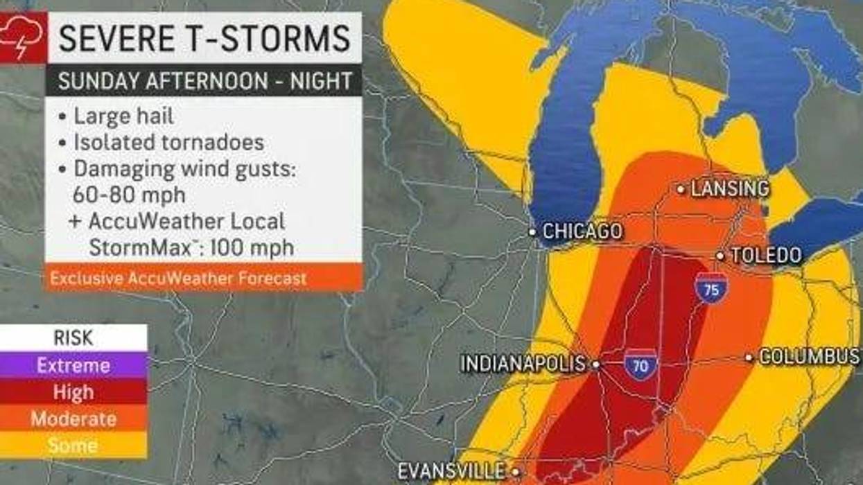
While much of Michigan is desperate for rain, it could do without hailstones up to 1" in diameter, damaging winds from 60 to 80 mph and isolated tornadoes -- but all are in the cards for all of Southeast Michigan come Sunday afternoon, forecasters warned.
"A line of thunderstorms is projected to move across Lower MI Sunday from mid afternoon through evening," the National Weather Service advised on Saturday, one day ahead of the potentially severe weather. "The tornado potential continues to be monitored."
In an update Sunday morning, the NWS said the severe weather potential has increased. A line of thunderstorms are expected to move across SE MI between 5-10 p.m., according to the service.
Main hazards will be damaging gusts between 60-70 mph, while "quick spin up tornadoes and/or hail up to golf ball size will also be possible tonight."
AccuWeather meteorologist Matt Benz told WWJ Sunday morning the initial line of storms in West Michigan is "expected to weaken" throughout the morning before regaining steam.
"As we progress into this afternoon, warmth and humidity will help to fuel these storms once again and that's when we'll see another line of thunderstorms picking up from west to east," Benz said.
While it looked "threatening" in the area Sunday morning, according to Benz, not much is expected to happen until later in the day.
While the center of low pressure moving into the Great Lakes region bring he highest risk of severe storms to segments of Indiana and Ohio, Michigan sits on the cusp of the bullseye.
The storms are projected to move west to east at around 45 mph.
While the NWS topped wind gusts out at 60 mph, AccuWeather meteorologists gave potential speed of 60 to 80 mph with the AccuWeather Local StormMax™ of 100 mph.
Stay tuned to WWJ Newsradio 950 for the latest weather updates every 10 minutes on the :08s.
Major League Baseball officials opted to stay ahead of the storms and moved up Sunday's 1:40 p.m. game against the Minnesota Twins at Comerica Park to 12:10 p.m. over the "forecasted in inclement weather."
"Tickets for the originally scheduled 1:40 p.m. game are still valid for the 12:10 p.m. game," the organization said on Twitter.
Fans looking for additional information can visit Tigers.com.
The stormy weather pattern is a break from the dry, hazy conditions that have shrouded skies across Michigan in previous weeks.
"Over the last few months, the Northeast and Great Lakes weather has taken dramatic turns, from warm and wet to dry and smoky. As we head into the first weekend of astronomical summer, the pattern will flip to humid and active weather with showers and occasional thunderstorms. This pattern looks like it lasts well into next week," said AccuWeather Meteorologist Dean DeVore.
Officials said actions can be taken more to prepare ahead of the storm, which could bring tornadoes. As outlined by MIREADY, residents can start their plans with the following tips:
• Identify safe rooms built to FEMA criteria or ICC500 storm shelters or other potential protective locations in sturdy buildings near your home, work, and other locations you frequent so you have a plan for where you will go quickly for safety when there is a Warning or an approaching tornado.
• For schools, malls, and other buildings with long-span roofs or open space plans, or many occupants, ask the building manager to identify the best available refuge. Build an emergency kit and make a family communications plan.
• Sign up for your community's warning system. The Emergency Alert System (EAS) and National Oceanic and Atmospheric Administration (NOAA) Weather Radio also provide emergency alerts. If your community has sirens, become familiar with the warning tone.
• Listen to NOAA Weather Radio or to commercial radio or television newscasts for the latest information. Meteorologists can predict when conditions might be right for a tornado. In any emergency, always listen to the instructions given by local emergency management officials.
• Be alert to changing weather conditions.
• Look for approaching storms.
• Look for the following danger signs:
-Dark, often greenish sky
-Large hail
-A large, dark, low-lying cloud (particularly if rotating)
-Loud roar, similar to a freight train.
-If you see approaching storms or any of the danger signs, be prepared to take shelter immediately.
Once the storms and rain move out by the middle of next week, a brief cooldown is possibly in store for Michigan as cooler air from Canada drops down behind the zone of low pressure. Tuesday's high will barely creep into the high 60s and lows will be in the mid-50s.