
(WWJ) - Metro Detroit is preparing for a rare February warm-up Thursday and even record-breaking heat on Friday, but weather experts say residents should enjoy it while it lasts as a potential winter storm could target the listening area next week.
While some Michiganders may break out the golf clubs, short sleeves and other warm weather gear as temperatures creep up in the mid 50s on Thursday with sunny, breezy conditions, AccuWeather meteorologist Dean DeVore said Friday's daytime highs will be one for the record books.
"I think upper 50s to near 60 [Friday] with some showers in the afternoon," DeVore said. "The record that day is 56, so I think we may break the record on Friday."
The record heat for the same day was set back in 2001.
But things won't be warm for long, DeVore warned.
According to AccuWeather, a flip in the weather pattern has the potential to turn the unusual warmth on its head and as the spring-like weather fades, chances of a snowstorm over parts of the Midwest and Northeast continues to grow.
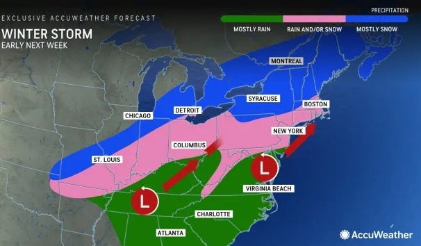
"While the January thaw and break from the stormy pattern extended into early February, there is going to be a change in the pattern with a potentially impactful storm coming swinging across the Midwest and Northeastern states from Monday to Tuesday," DeVore said.
The system meteorologists are keeping an eye out for is expected to begin appearing over parts of the southern High Plains on Sunday and extend across portions of the lower Mississippi Valley to the Ohio Valley from Sunday night to Monday.
Snowfall is so far forecasted to be slight as the air may still be too warm for snow, resulting in more of a rain event.
But colder air will is expected to be drawn into the storm as it moves from the Central states to the East Coast -- although the timing and strength of the storm is still difficult to pinpoint.
"If the storm remains weak, it will likely race eastward with only small snow accumulations from the Ohio Valley to the central and southern Appalachians and perhaps a wintry mix in the mid-Atlantic late Monday into Tuesday," AccuWeather said. "Should the storm organize and strengthen, it would track farther north to produce a broadening swath of accumulating snow from the central Appalachians to New England, with drenching rain and thunderstorms to the south."
If it does reach its full potential, the storm is capable of producing heavy snowfall that may cause some communities in its path to dig out prior to Valentine's Day.
This is a developing news story. Stay tuned to WWJ Newsradio 950 with traffic and weather together on the :08s for the latest details as they become available. >>> LISTEN LIVE!