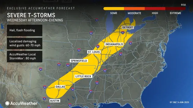

DETROIT (WWJ) -- There's a chance for a gusty thunderstorm or two in Metro Detroit on Wednesday, as warmer air moves to our area.
The National Weather Service is warning that isolated severe storms are possible in the afternoon and evening on June 4, capable of producing wind gusts to 60 mph and heavy rainfall in some area.
AccuWeather Meteorologist Heather Zehr said Metro Detroit will heat up to around 87 degrees with some intervals of sunshine, out ahead of this storm system.
She said the chance for severe weather in the WWJ Newsradio 950 listening will begin at around 2 p.m. or 3 p.m.
"After that it looks like they'll start moving into areas off to the northwest of Detroit and they'll continue to spread off to the south and east as we go into the afternoon, likely reaching the city as approach the evening rush," Zehr said. "So that's something to keep in mind for your drive home."
According to the National Weather Service, Metro Detroit remains in the "marginal risk" area for severe weather on Wednesday, from 2 p.m. until around 9 p.m.
Looking ahead, NWS said there's a lingering chance for showers in Metro Detroit on Thursday, particularly for areas south of I-69. There's less of a chance for more rain on Friday, but a shower or two can't be ruled out.
The good news for Thursday and Friday: the humidity is expected to drop in Metro Detroit, with more seasonable temperatures in the mid-70s.
For the weekend, it's looking pretty pleasant, with more temps in the 70s and a mix of clouds and sunshine.
Don't get caught out in it! Stay with WWJ Newsradio 950 for the latest weather updates, along with traffic, every 10 minutes on the 8s. To stream us live anywhere, download the free Audacy app and follow WWJ. >>LISTEN LIVE!!