DETROIT (WWJ) - Metro Detroit lucked out on winter storms as of late that struck other parts of the Midwest with heavy snowfall, icy conditions and high winds, but yet another monster storm is headed our way -- bringing with it a chance for over a foot of snow and blizzard conditions.
While warmer temperatures spared Southeast Michigan the worst of Tuesday's storm that buried West Michigan in six inches of snow, Mother Nature won't be as forgiving this time around with a stronger and colder "bomb cyclone" blizzard, set to strike Friday into Saturday, AccuWeather experts warn.
A "bomb cyclone" is a common phrase for bombogenesis, which is a storm that undergoes rapid strengthening.
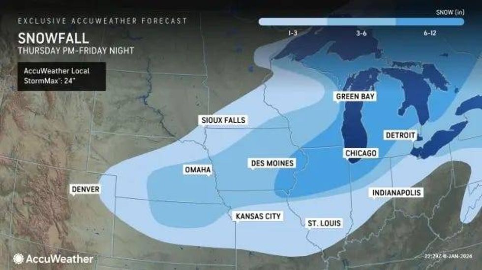
Metro Detroit appears to be more directly in the storm's path, which is expected to track a hundred miles further to the east than its predecessor. This shift would put more areas in the Midwest -- including Detroit -- at risk for blizzard conditions that would make travel dangerous, if not stop it entirely, with whiteout conditions, large snow drifts, strong gusts and wind chills temps forecasted to clock in below zero.
 accuweather
"Blowing and drifting snow will be much more substantial and widespread during and following the second storm and could make the complete removal of snow nearly impossible," AccuWeather warned. "Some roads may become clogged with large drifts and stranded vehicles. Those who attempt to drive even short distances during the furious winter storm may be at risk of becoming stranded."
AccuWeather Meteorologists Dean DeVore said warmer temperatures will mix in at first, with highs in the upper thirties on Friday, but dangerous cold will take hold and cause any rain to switch over to snow.
"As the blizzard conditions take hold Saturday, winds [will gust] to 50 mph and temperatures [will fall] through the 20s, with RealFeels into the single digits," DeVore said.
Those immediately in and around Detroit are forecasted to get three to six inches of snow with northern and western suburbs expected to see six to twelves inches of snow. DeVore warned the snowfall amounts might be hard to measure as it will be blowing around.
According to AccuWeather, anyone who finds themselves outdoors during the storm would be at risk for hypothermia and frostbite as peak winds are predicted to range between 40 and 60 mph, and push AccuWeather RealFeel® Temperatures well below zero Fahrenheit.
"Actual temperatures may struggle to climb past the single digits during the day and dip below zero at night in vast portions of the central and Plains and Upper Midwest this weekend as Arctic air blasts in," meteorologists said.
The frigid temperatures along with strong winds will lead to rapid ice build-up along the Great Lakes and freezing over wash and spray along shorelines. The Arctic blast is also predicted to produce bands of heavy lake-effect snow immediately after the storm.
"There is the potential for snow to be measured in feet where the snow bands persist," AccuWeather added.
Don't miss a thing! Stay with WWJ for traffic and weather updates, every 10 minutes on the 8s, listen anytime on the free Audacy app, or tell Alexa: "Play WWJ nine-fifty."