LATEST>> Ice Storm Warning issued for Macomb, Oakland, St. Clair, Livingston and Washtenaw Counties: "Travel could be nearly impossible."
-------------------------
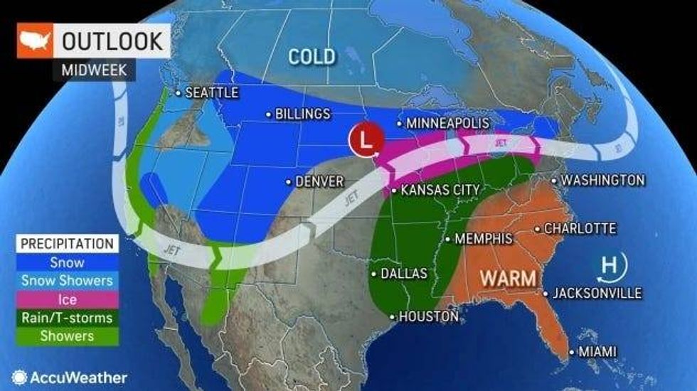
METRO DETROIT (WWJ) - An enormous winter storm is due to pummel the Great Lakes region beginning Wednesday, bringing the threat of snow, sleet and freezing rain with significant ice accumulations forecasted for Metro Detroit.
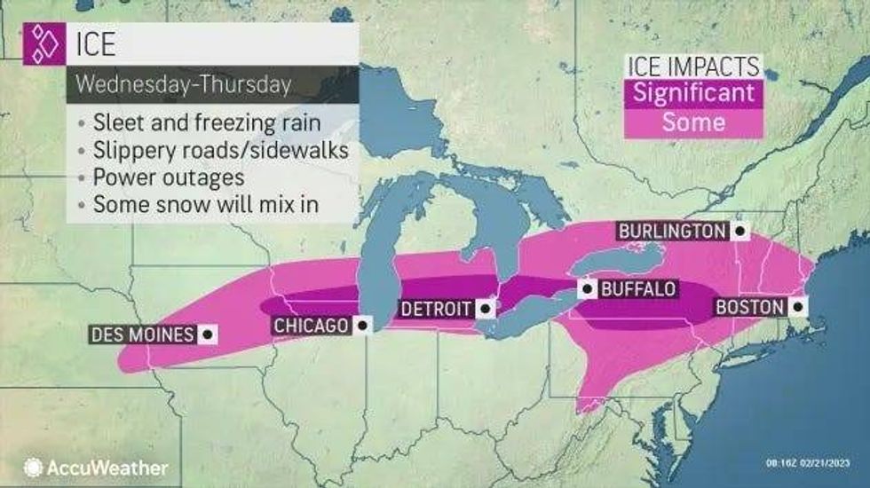
The National Weather Service has issued an Ice Storm Warning for Macomb, Oakland, St. Clair, Livingston and Washtenaw counties, in effect from noon on Wednesday through 4 a.m. Thursday.
Areas of Southeast Michigan not covered by the Ice Storm Warning — including Wayne, Monroe and Lenawee counties — are under a Winter Weather Advisory from 10 a.m. until 8 p.m. Wednesday.
 AccuWeather
"Heavy mixed precipitation possible with total snow accumulations of up to two inches and ice accumulations of up to two tenths of an inch possible," the NWS warned. "Winds could gust as high as 35 mph."
AccuWeather meteorologists said the listening area will most likely see a "substantial" amount of ice that could force Detroit's Metro Airport to close -- travels are warned to prepare now for potential flight delays and cancellations.
Hazardous conditions on roads and freeways are likely.
Experts said a glaze of ice from 0.25 to 0.50 of an inch thick on surfaces could lead to widespread power outages and downed trees.
As of Tuesday morning, the NWS said they are seeing temperature trends warming slightly which would lessen how long and how much ice could impact Metro Detroit area.
"This has not been a terrible winter in terms of wintery weather, I think the worst of the iciness maybe just north of the heart of the city and the Detroit Metro, but I think it's going to be bad enough," WWJ's AccuWeather Meteorologist Dean DeVore told Jackie Paige. "
Meteorologists say the ice potential has now shifted north of I-94 towards the I-69 corridor, but they cannot completely rule out ice in the lower regions beginning in the latter part of Wednesday.
"Slight chance of precipitation towards daybreak tomorrow and as it does, it comes in with a mix of rain, sleet and snow and then it goes over to more rain in the afternoon as we get into the mid-upper 30s," DeVore said. "We could go back into some iciness as we get into tomorrow night and Thursday morning as temperatures sag back down close to the freezing mark, but then Thursday, icy to start in some places then rain showers and wind takes temperatures up into the low 50s for a couple of hours midday into the afternoon."
 AccuWeather
Experts said that the difference between freezing rain/sleet/rain in the area will be greatly depend on the temperature, which is predicted to fluctuate to above and blow freezing.
Weather experts said accumulating snowfall will hit the northern Tri-Cities area and far northern Thumb region where 2 inches of snow is expected.
The massive winter storm bearing down on Michigan will stretch 2,600 miles from coast to coast across the northern United States this week. Behind this system, AccuWeather meteorologists say strong winds will develop on Thursday, with some leftover rain and highs in the mid-40s.
Friday we could see some sunshine although it will be frigid with a shot of cold air, DeVore said. Metro Detroit will only see a high of around 25 degrees, and a low of 15.
Stay with WWJ Newsradio 950 for traffic and weather updates, every 10 minute on the 8s. At home, tell Alexa to "Play WWJ nine-fifty."