
(WWJ) Survey teams from the National Weather Service have been out in the field all day Wednesday, checking out the damage after multiple tornadoes touched down in Michigan on Tuesday.
At least one tornado has been officially confirmed by NWS so far: at around 6 p.m. in Kalamazoo County's Portage. It is believed that a second tornado — as reported by a trained spotter — touched down in Portage about an hour later.
In an update late Wednesday afternoon the NWS released official information about the first twister in Portage, confirming it was an EF-2 tornado that had an estimated peak wind of 135 mph.
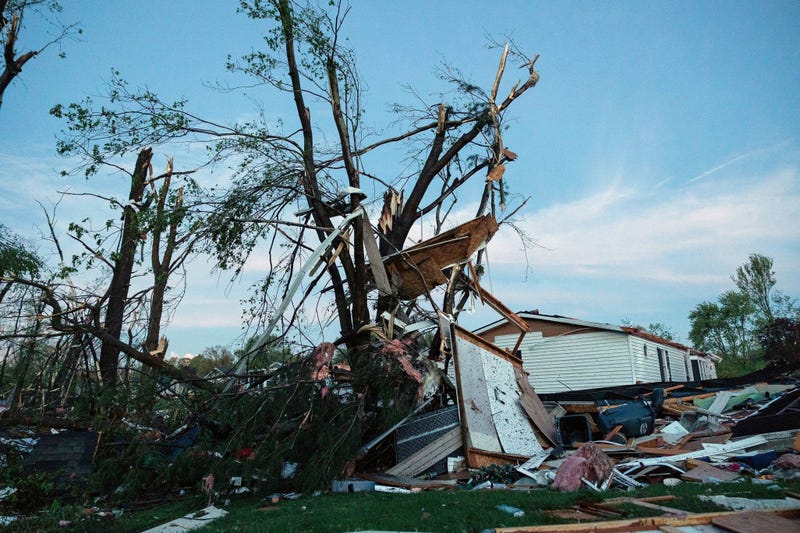
It was an estimated 300 yards wide and was on the ground for about 11 miles, according to the NWS. It touched down at around 5:55 p.m. near South 10th Street and West R Avenue and lifted around 6:17 p.m. in the area of East N Avenue, west of 31st Street. Hundreds of trees were snapped and uprooted along the path.
Along the tornado’s path, NWS officials say many homes had heavy roof and/or siding damage, while two mobile home parks were impacted. Many mobile homes were completely destroyed in each park.
A number of businesses had significant damage along the path, while multiple apartment complexes were also impacted with apartments on Timbercreek Court seeing the most significant damage, according to the NWS.
A large section of the roof of a FedEx warehouse also collapsed near the Kalamazoo/Battle Creek International Airport.
Numerous homes and commercial buildings were damaged, including the Portage FedEx facility which was ripped apart.
Officials in Kalamazoo County said 16 to 20 people were taken to hospitals for treatment of minor injuries suffered during these storms, but no one was seriously hurt or killed.
A third tornado was reported in Union City, south of Battle Creek. As of 6 p.m. Wednesday, the NWS had not yet released official reports about that tornado, or the second one reported in Portage.
As surveys continue, MLive reported Wednesday morning that there was some confusion swirling to how many tornadoes actually touched down.
As the storm system moved across Michigan, MLive says the NWS issued several Tornado Warnings of “radar indicated" tornadoes or twisters, identified by their rotation and debris as seen on radar. Issuing Tornado Warnings in Calhoun and Van Buren counties, the NWS said “a large, extremely dangerous and potentially deadly tornado is on the ground.”
But tornadoes in those counties have not yet been confirmed.
While there have been reports of up to ten twisters seen in Michigan Tuesday, the Associated Press reported some of these may have been duplicate reports passed along by people who saw the same tornado. According to the NWS in Grand Rapids, it could take a few days before we have a final answer.
While the number of tornadoes remains in question, we're expecting to learn more about how powerful they were.
WWJ Newsradio 950 spoke with NWS Meteorologist Ernie Ostuno, who said NWS crews would be out in Kalamazoo County gathering information more information on the wind rating and strength of the tornadoes.

He said the one confirmed confirmed tornado covered a lot of ground: around 10-to-15 miles. A normal strength tornado in Michigan usually tracks at EF-0 or EF-1, but due to the structural damage in Portage, Ostuno said we could see a higher level rating.
He said NWS will be working directly with county and city officials to assess the damage, which could take several hours.
"They'll usually give us, you know, the specifics on locations, and also come with us to tour the damage," Ostuno explained. "You know, a lot of times the worst damage is going to be closed off to the public. So, we'll work with the emergency managers to get in there and look at the worst structural damage through the area that the tornado moved through."
Ostuno said forecasters do expect to see more severe weather heading into Michigan over the summer months. He urges Michiganders to pay attention to the weather forecast, heed any warnings, and have a plan for a safe place to take shelter.
Gov. Gretchen Whitmer Tuesday night declared a state of emergencyfor Kalamazoo, St. Joseph, Branch, and Cass counties. The declaration makes available all state resources in cooperation with local response and recovery efforts in the designated area, and authorizes the Michigan State Police, Emergency Management and Homeland Security Division to coordinate state efforts above and beyond what MSP/EMHSD has already been doing in conjunction with local agencies.
Stay with WWJ Newsradio 950 for the latest information.