
SOUTHFIELD (WWJ) -- It'll be a warm and humid day in Metro Detroit, ahead of some expected wild and windy weather rolling in Thursday night.
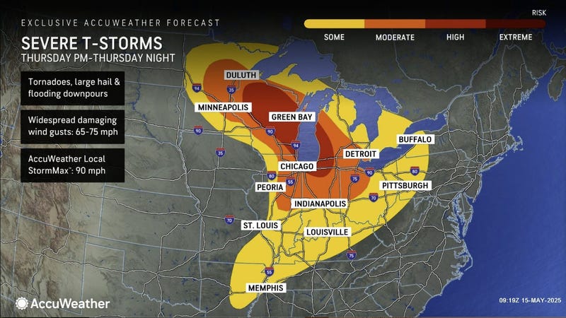
AccuWeather Meteorologist Joe Lundberg said strong thunderstorms are likely to blow through the Southeast Michigan region late on May 15 — with the best chance for severe weather from 10 p.m. through around 4 a.m. Friday.
Speaking live on WWJ Newsradio 950, Lundberg said the impacts could be widespread across the Metro Detroit area.
"I think we're looking at the certainly damaging wind gusts are high on the list, a threat of hail and flooding downpours," Lundberg said.
"I think low on the list, but not zero, is the risk of a tornado. And all of this is gonna come under the cover of darkness — probably after about 10 o'clock, 11 o'clock, and then by 4 or 5 in the morning, they're gone," he said. "So, that's the window... While most of us are trying to sleep, we're probably gonna get rumbled out of bed by these strong to severe thunderstorms."
Highs will get into the lower 80s, with an overnight low around 66 degrees.
On Friday, Lundberg said it'll be a breezy and very warm day, with lower humidity and a high of 86 degrees.
Looking ahead to the weekend, AccuWeather is calling for a windy and cooler Saturday in Metro Detroit, with sun and clouds, maybe a shower or two, and a high of 66 degrees.
Sunday is looking dry and mostly cloudy with a cool breeze and a high of around 66 degrees.
Know before you go! Stay tuned to WWJ Newsradio 950 for the latest traffic and weather updates every 10 minutes on the :08s! >>> LISTEN LIVE!