METRO DETROIT (WWJ) - What's more fear-inducing than ghouls, goblins and ghosts? Telling your children they'll have to incorporate a heavy coat with their Halloween costumes as snow flurries are forecasted to fall just in time for trick-or-treating.
"Halloween is dressing like Christmas, right?" WWJ's AccuWeather Meteorologist Dean DeVore joked on Tuesday morning -- only he wasn't joking.
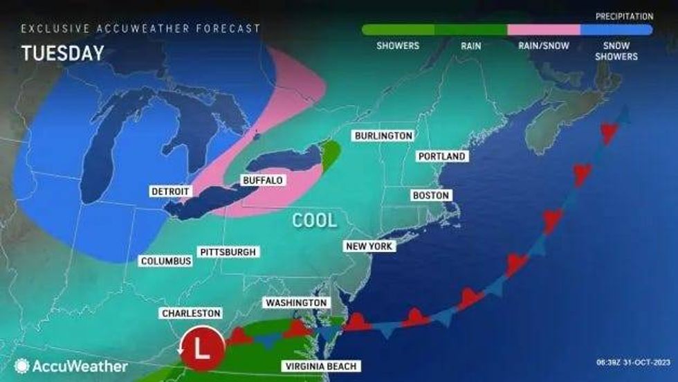
Flurries began flying early Tuesday in West Michigan and the central and northern parts of the Lower Peninsula, as a quick-hitting snowstorm more typical of December came blowing through on Halloween.
Some parts of West Michigan, including the Grand Haven and Muskegon areas have already seen at least four inches of lake effect, with more expected into the evening.
A Winter Weather Advisory is in effect for parts of Muskegon, Ottawa, Oceana and Newaygo Counties until midnight. The NWS says an additional 1-3 inches are expected by the end of the night.
Sabrina with J&J Farms Sales and Service in North Muskegon told WWJ's Jon Hewett snow was in the forecast, but she was not expecting this much.
"I am looking at probably about six inches sitting on our trucks right now," she said around 4 p.m. after the area got hit with heavy lake effect snow. "We figured it would be a couple inches at most and be light and fluffy, but this is wet and heavy. Lakeside is awful."
Video from Saugatuck, along the shores of Lake Michigan south of Holland, shows a resident shoveling snow from the porch as trick-or-treaters come and go with about 2 inches of snow on the ground.
As of 6 p.m. Consumers Energy was reporting about 35,000 customers without power -- mostly in the Muskegon area -- as a result of the heavy snow and falling tree limbs taking down power lines.
As for the Metro Detroit area, AccuWeather's Brian Thompson said Tuesday afternoon on WWJ there will be a few snow showers, but "most of them won't really amount to anything."
"But any heavier snow shower could reduce visibility briefly and perhaps even cause a few slippery spots," Thompson said.
"We're seeing some heftier snow showers that will arrive here later on this morning into the afternoon and evening, already out around the Chicagoland area, so it's coming at us from the west northwest and we will spin in here as we go through the day," DeVore said Tuesday morning.
Temperatures were expected to hold steady in the upper 30s and possibly creep into the upper 40s at the peak of the day Tuesday, but come trick-or-treating time, it'll feel like winter.
An Alberta Clipper system, a type of storm notorious for triggering snow flurries, lake-effect snow and sudden snow squalls, could pose a serious problem for those out on the road, especially if the snow starts steadily falling at times of heavy traffic and brings a sudden drop in visibility.
 AccuWeather
"Figuring road conditions during early-season snowfall events such as this week's clipper storm is always tricky due to the warm ground and the effect it has on quickly causing the snow to melt as it falls," AccuWeather Senior Storm Warning Meteorologist Brian Wimer said, adding, "However, the nature of snow squalls can bring a quick, small slushy accumulation that can lead to dangerous conditions on the highway."
DeVore said Detroit and its surrounding cities might escape this first dose of winter weather -- but it's not a for-sure guarantee.
"Some snow showers that will likely whiten the ground the farther north and west you go from Metro Detroit. Near and beyond that I-69 corridor, that's where we could see a few slick spots, but closer to the city I think things that will just kind of make us go pause and understand that we are about to go into November tomorrow," DeVore added.
Those going out for Halloween should pack the gloves, scarfs, hats and coat because not only is snow in the forecast, but temperatures will be frigid.
Lows will plummet into the upper twenties overnight, a nearly 50 degree difference from the 70 degree weather that graced the Metro Detroit area last week.
The cold will remain with us going into the start of November, with the return of some sunshine up to 42 degrees on Wednesday. Thursday will see highs climb into the upper 40s with some clouds and the warming trend continues into Friday where highs are expected to get into the mid-50s with some sun.
The 50s will hang around into Saturday with the possibility of rain showers.