
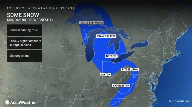
DETROIT (WWJ) - A clipper storm dropping down from Canada is bringing wintry travel conditions to the Detroit area where accumulating snow is expected to coat roadways and reduce visibilities during Tuesday's morning rush hour.
According to the National Weather Service, snow will move into Metro Detroit early Tuesday morning with bursts of moderate to heavy snow that will reduce visibility to one mile or less at times -- with rapid fluctuations of visibility expected -- and quickly accumulate snow.
Meteorologists say one to two inches of snow, with localized amounts up to three inches, is expected by 10 a.m., especially between the I-69 and I-94 corridor.
"It's coming," AccuWeather meteorologist Dean DeVore said. "If you're going out I-94, it's just past Chelsea towards Jackson where it's really heavy. If you're going out I-96, it's right around the leading edge of it around Howell. If you're going up I-75, the leading edge of it into Flint and some of those areas just to the south of Flint. So these are the areas where it's already snowing."
The clipper storm -- which is a very fast-moving system that drops down from the northwest across the Great Lakes from Central Canada -- will usher in cooler air with DeVore stating temperatures have already dipped to or below freezing.
"With the exception of downtown, that's still 34F, but other places I'm seeing are 31F and 32F," DeVore said. "So as this brief burst of snow comes through the morning commute, watch out for poor visibility and slickness."
Along with with snow, south winds will blow steady at 10 mph with gusts to 15 mph.
The NWS issued the same warning, stating the combination of snow and cold temperatures will result in localized icy roadways and variable traffic rates throughout Shiawassee, Genesee, Lapeer, St. Clair, Livingston, Oakland, Macomb, Washtenaw, and Wayne counties.
"Motorists are urged to use caution and account for the variable driving conditions by allowing extra time," the NWS said.
According to DeVore, the first round of snow will bring a coating to an inch of snow before a rainy-snowy mix affects the area for the rest of the day Tuesday as temperatures hold steady in the low to mid thirties.
"And that's where we'll stay tonight with some more rain and snow showers overnight," DeVore added.
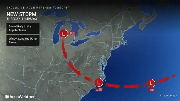
Looing ahead, AccuWeather forecast says a zone of high pressure will move over into the Midwest, promoting a period of drier weather.
"Later this week, a front can swing southward out of the Great Lakes to the Southeast as another storm pushes out of Canada into parts of the Northeast," AccuWeather warned.