
DETROIT (WWJ) - Damaging wind gusts, frequent lightning and heavy rainfall are all in the cards for Michiganders on Friday evening as the potential for explosive thunderstorms push into the state's southern regions.
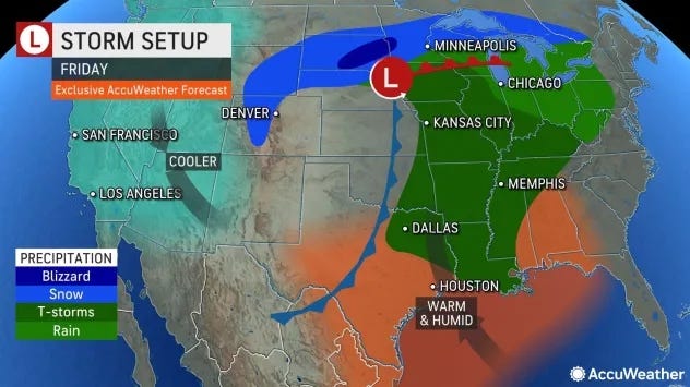
At the same time, the Upper Peninsula is the crosshairs of a major winter storm predicted to bring dangerous blizzard conditions and up to 18" of snow.
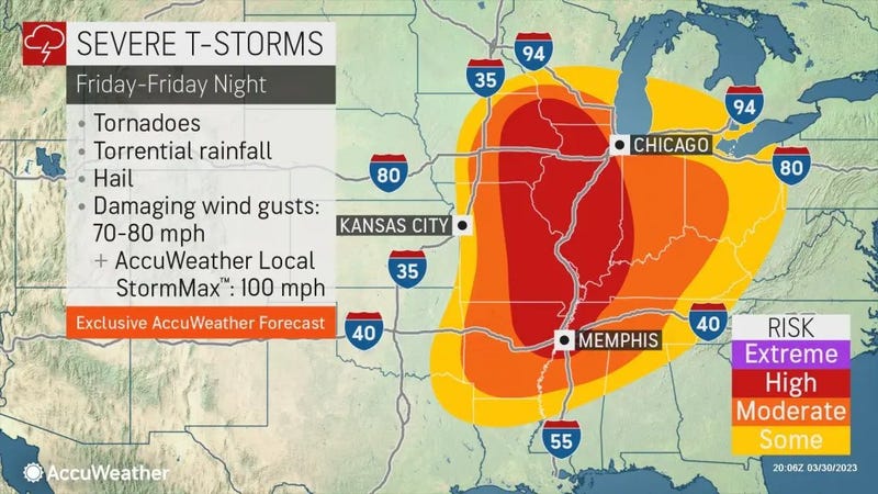
According to the National Weather Service's Storm Prediction Center, the weather outbreak striking the state is all part of a monster cross-country storm that will put more than 75 million Americans at risk for some form of severe weather on Friday.
The Metro Detroit area will likely see violent storms swing through during the overnight hours -- and forecasters there is a potential for tornadic activity.
"We are going to see rain tapering to some showers as we head into the afternoon. There may be a rumble then, but there's going to be some breaks in the action this afternoon as we get within a few degrees of 60," WWJ's AccuWeather Meteorologist Dean DeVore explained. "The intensity of stuff picks up again tonight with the best chance for severe weather, early damaging wind gusts, maybe an isolated tornado south and west of Detroit."
While all appears quiet on Friday morning, meteorologists said a jet stream will clash in the Mississippi Valley region with warm air and moisture from the Gulf of Mexico, creating the perfect conditions for severe thunderstorm development.
"As the storms grow in number and intensity, they are likely to form a solid line, sometimes referred to as a squall line," AccWeather experts said. "The risks of tornadoes, damaging straight-line wind gusts and torrential downpours will extend well beyond the daylight hours on Friday as the storms advance across the lower Great Lakes and the Ohio and Tennessee valleys."
Experts warn that severe weather occurring after dark greatly increase the risk of injuries and deaths, as seen with the deadly tornado that struck Rolling Ford and Silver City, Miss. last week.
Related

Friday's storms are forecasted to race through the area at speeds between 40 and 60 mph, drastically reducing the time residents can take shelter.
Michiganders are strongly encouraged to stay up-to-date on weather bulletins throughout the night, as well as taking time now to go over a severe weather plan prior to the storms' arrival.
Even if a tornado does not form, experts explained the high wind gusts associated with the lines of thunderstorms can still be enough to uproot trees, damage mobile homes, blow over vehicles and knock out power.
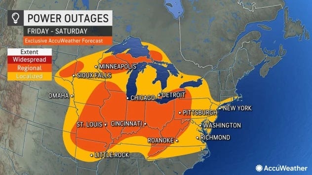
The storms are also forecasted to unleash heavy, localized rainfall, bringing the risk for secondary river flooding to the Metro Detroit area.
Residents in the Upper Peninsula, meanwhile, are gearing up for a late winter storm brewing from the same weather system.
Related

The storm will bring a combination of strong winds and heavy snow that experts say will reduce visibility for a time in many areas and may produce dangerous blizzard conditions.
"There is going to be blowing and drifting snow, along with dangerous travel conditions, during the second half of the snowstorm," said AccuWeather Senior Meteorologist Alex Sosnowski. "These conditions will even linger for a time shortly after the storm exits, due to low temperatures and strong winds."
The NWS in Marquette said travel will be treacherous as the U.P. is forecasted to receive some of the heaviest snow totals.
"Impactful winter weather will start this evening and continue through Saturday afternoon," experts said. "This system will create a wintry mix of heavy snow, freezing rain and rain through Friday morning with 1 to 6 inches of snow and up to 0. 15 inch of ice."
The severe weather comes less than a month before the one year anniversary of the the deadly EF3 tornado that devastated the city of Gaylord last year.
On May 20, 2022, a large, destructive tornado touched down in Northern Michigan, leaving behind near total devastation. Two people were killed and over 40 others were injured as the EF-3 tornado tore homes from their foundations and ripped apart businesses.
The Gaylord tornado sustained peak winds estimated at 140 mph, the National Weather Service said — the last tornado to hit Michigan with a rating of EF-3 touched down in Dexter in 2012.
According to meteorologists, Michigan sees an average of 15 tornadoes each year. Tornadoes take about less than 15 minutes to form.
Related
