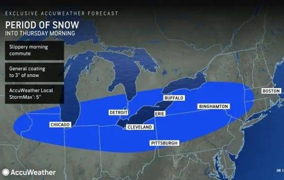
DETROIT (WWJ) - The first wave of a two-part snowstorm is already causing headaches for drivers in Metro Detroit as accumulating snow and blustery conditions coat roadways and reduce visibility during the Thursday morning commute.
While it won't be a major storm like the one that struck Southeast Michigan last weekend, AccuWeather meteorologists said different parts of the storm will hit some localized areas harder than others.
WWJ AccuWeather meteorologists Dean DeVore warned that the steadiest snowfall across Metro Detroit will occur during the Thursday morning rush hour.
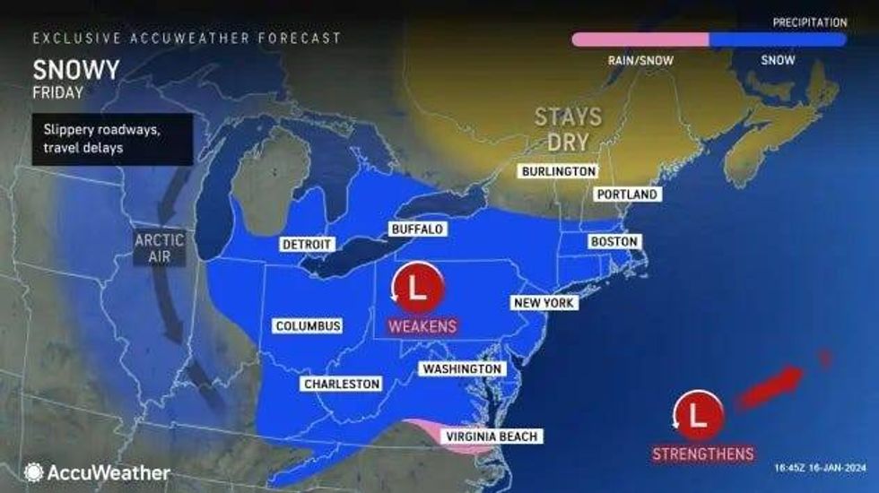
"We're in the first of two separate snow events and steady snow this morning should taper to some flurries that maybe even end for a bit this afternoon into this evening and then the snow picks up again, a second piece tonight into tomorrow," DeVore said.
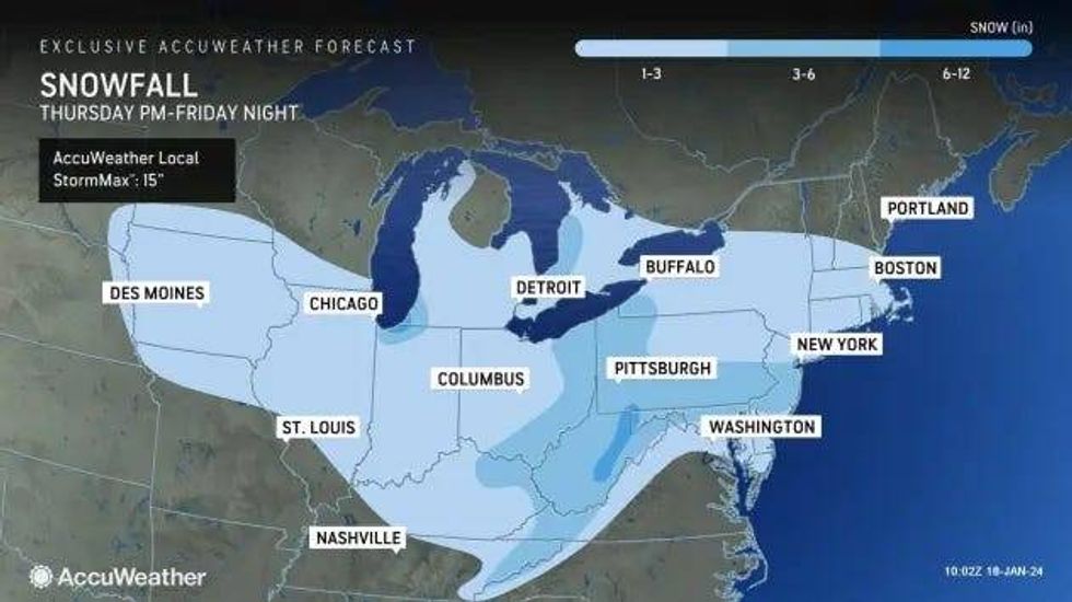
Roughly a coating to 1-2 inches are expected to fall, especially around Detroit and southward, during the first storm system while the second storm on Friday is forecasted to bring 1 to 3 inches of snowfall.
"When it's all said and done, [it'll be] blustery and bitterly cold as we get into the rest of tomorrow and then also into the day Saturday," said DeVore, adding that whatever snow does fall, gusty winds will cause it to blow over roadways and create slippery conditions.
But the drive for many Metro Detroiters is already worsening Thursday morning, with WWJ's Charlie Langton reporting vehicles on Royal Oak were traveling well below posted speed limits on snow-covered roads.
"I'm on Southbound Woodward between about 15 Mile to roughly 12 Mile here -- the speed limit is 45 mph on Woodward, but I've only been able to go about 35 to 40 mph," Langton said. "Not too many cars are passing me either and the reason is because the roads are slippery."
At 6:00 a.m., Langton reported lightly falling snow was impacting the area, but the snowfall was heavier earlier, leaving behind a coating over the road making lanes hard to see.
The snowfall is also being kicked up by passing vehicles and wind gusts that can easily affect the visibility of other drivers, Langton warned.
"The [other] problem is is that when you turn, you're gonna skid and when you're pulling into a parking lot like I'm at right now, it is very, very slippery out here. A little deceiving here, so be very, very careful," Langton warned.
 AccuWeather
 AccuWeather
 AccuWeather
WWJ traffic reporter Michelle Peña said there are a number of crashes and other hazards greeting drivers heading into the 7 a.m. hour. Crews are continuing to working on a crash along westbound I-696 at the Lodge Freeway that has only the left lane open.
"Drivers are now backed up near Evergreen. You'll want to use 12 Mile as your alternate," Peña advised.
Also along WB I-696 to Telegraph out to the I-96/ I-275 interchange, multiple cars are off to the shoulder with flat tires due to suspected potholes that are hard to see over the dusting of snow, Peña said, so drivers will also want to use 12 Mile as an alternative route.
There are a number of other crashes reported throughout of the Metro Detroit area that is snarling traffic as the morning commute picks up.
On I-75 southbound at Adams, a small pickup truck struck the median wall and is still blocking the left lane and shoulder.
"Have a crash though working I-275 northbound just after Michigan Avenue .A couple of crashes on the Jeffries Freeway, one westbound at Newburgh, another eastbound at Outer Drive involving spin outs and an accident also working I-94 westbound at I-75," Peña warned. "Then there's some traffic lights flashing red on Telegraph at I-94, so be careful as you head through that stretch as well."
DeVore mentioned that the snow and bitter cold will let up going into Sunday as temperatures ease a bit, but Metro Detroiters should be prepared for the next system forecasted to bring yet another round of wintry mix, including sleet, freezing rain and rain as we go Monday night into Tuesday.