SOUTHFIELD (WWJ) -- Southeast Michigan could see more than half-a-foot of fresh snow accumulation from a winter storm blowing through on Wednesday, with the highest amounts expected north of Detroit.
A Winter Storm Watch is now in effect for a portion of the WWJ listening area, including Macomb, Oakland, Genesee, St. Clair. Livingston and Shiawassee counties, through 7 a.m. Thursday (2/13).
The NWS said widespread snowfall is expected in these counties — accumulating between 5 and 8 inches. There's also a chance for some sleet in the mix, creating an icy glaze on the roads.
A Winter Storm Warning is in effect for Lapeer and Tuscola Counties, and a limited eastern portion of Southeast Michigan. This does include parts of Macomb County as well as the Thumb. (See area in purple on map below)
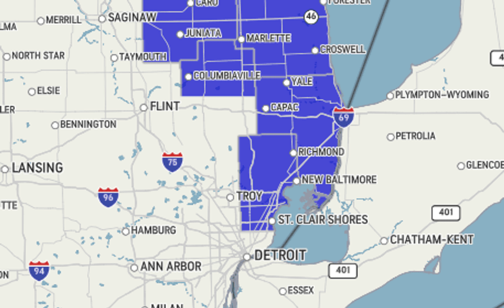 NWS
NWS
Meanwhile, a Winter Weather Advisory is posted for all of Southeast Michigan. In addition to the counties listed above, this includes Wayne, Lenawee, Monroe, and Washtenaw, and Wayne counties, which are expected to see total snow accumulations between 2 and 4 inches and ice accumulations up to around one tenth of an inch.
Drivers are urged to plan ahead because travel could be very difficult, late Wednesday afternoon into early Thursday morning.
"Areas north of the city where it's all snow and you get a little lake enhancement off of Lake Huron, you may do upwards of 8 inches out of this, said Lundberg speaking live on WWJ Newsradio 950 Wednesday morning. "But, a blanket average of 4 to 8 inches. Again the lower end down toward the Ohio border when it's all said and done late tonight, and higher totals to the north of the city."
Forecasters say areas south of I-94 have the best chances to see a transition to freezing rain in the overnight hours, with greatest ice amounts focused towards the Ohio Valley.
If you have to travel, make sure your vehicle is ready for the snow.
Officials suggest packing an emergency kit before hitting the road: with a phone charger, blankets, flashlights, and first-aid kit.
Fill up your washer fluid and make sure your wiper blades work before heading into the snow.
Triple A says to avoid a tow, it's a good idea to check your car's battery strength and make sure your tires are inflated.
Many schools are announcing they'll be closed Thursday due to the snow, and some local universities announced early closures on Wednesday. Oakland University said it would close at 5 p.m. Wednesday and remain closed until early Friday morning. Lawrence Tech closed at 3 p.m., and the University of Detroit-Mercy closed at 4 p.m. Wednesday and will remain closed Thursday. Oakland Community College said it would close at 5 p.m. Wednesday, with all campuses remaining closed until Friday.
Many cities have declared snow emergencies.
Thursday, behind the storm, AccuWeather said it'll stay brisk and cold with lots of clouds and a couple of lingering flurries and a high 29. The roads may remain slick in spots during the Thursday AM commute — so continue to use caution.
It'll be cold again on Friday with clouds, some sun and a high only in the low to mid-20s.
Looking ahead into the weekend: AccuWeather forecasters are highlighting the risk for another storm to develop across the Central states before trudging across the east, bringing potentially another round of impactful weather across the nation. It's looking like the best chance for significant snow in Metro Detroit with that round will be Saturday (2/15).
Get the detailed daily AccuWeather forecast HERE.
Don't get caught in the storm! Stay with WWJ for weather updates along with traffic, every 10 minutes on the 8s. Tell your smart speaker to "play WWJ nine-fifty" or download the FREE Audacy app to stream WWJ anytime. >>LISTEN LIVE