
METRO DETROIT (WWJ) - Wednesday's snow storm was only the beginning, expert warned, with chances of flurries persisting into the weekend and a bigger weather system expected to impact Southeast Michigan on Saturday.
"We are back to winter friends," WWJ AccuWeather Meteorologist Dean DeVore said on Thursday morning as temperatures registered within a degree or two of 29° in the Metro Detroit area.
"It's not the coldest temperatures we've ever seen, but cold enough to support snow and pieces of energy keep coming at us," DeVore said.
While some of the weather is fueled by storms that hit the West Coast earlier, DeVore explained, the atmosphere in general and lake effect is also to blame.
A passing front on Thursday will generate snowfall as a result of these factors with accumulation estimated around an inch with higher totals possible in some areas.
"We're already seeing the heavier snow showers in the western side of Michigan," DeVore said. "Those move eastward and I'm concerned about the intensity of those snow showers and what they will do this afternoon and into this evening."
He warned Metro Detroiters to prepare for poor visibility and brief whiteout conditions with some of the incoming snow showers. Slick roadways may also pose another issue for residents as temperatures hover within a few degrees of the freezing mark then drop even colder into the low 20s after sundown on Thursday night.
Friday will see temperatures back in the low 30s, DeVore added, with a chance of flurries in the afternoon hours that could cause slick spots on the road.
But the potential for an even bigger snow maker looms over the weekend.
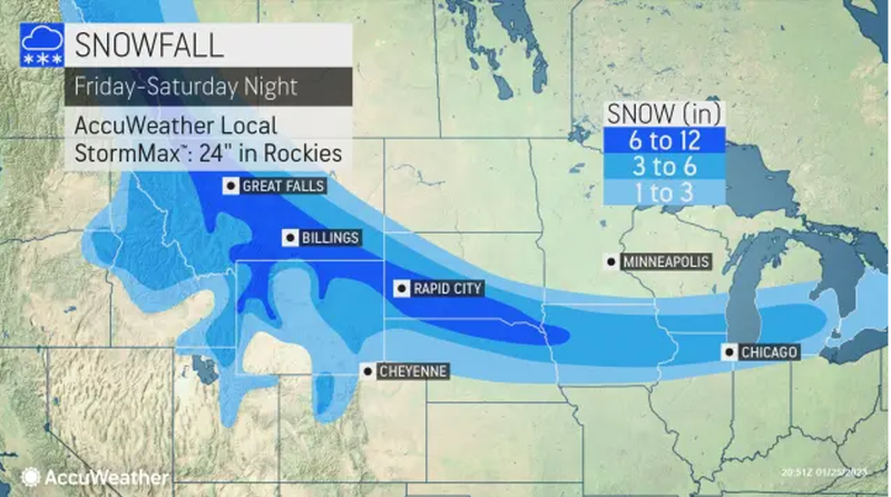
AccuWeather meteorologists have continued to track a brewing storm that is forecast to deliver a punch from the northern Rockies to portions of the northern and central Plains and Great Lakes, including Detroit, by Jan. 26.
"The bigger system looks like it's later Saturday into Sunday and right now, if I put a number to that, it could be in the three to six inch range in that system right now," DeVore said.
The system, called an Alberta clipper, will drop quickly southeastward from British Columbia and Alberta, Canada, in the next two days, before making a turn eastward and coming across the central United States to impact the Metro Detroit area.
As of Tuesday, Detroit, along with other cities like Chicago, had fallen short of their seasonal snowfall totals, experts said.
"Chicago typically receives about 18 inches of snow by the last week of January, while Detroit averages about 22 inches," AccuWeather meteorologists explained. "Even after factoring the snow from Wednesday's storm, Chicago has recorded a mere 9.8 inches. Detroit is now closer to normal, with a total snowfall of 17.6 inches."
After Wednesday's storm, Detroit achieved a daily record for Jan. 25 with a recorded 6.5 inches of snow.
Related
