Sunny but chilly today, so bundle up! Temperatures north of the lake will be in the 30s while south of the lake will see 40s but the wind will make it feel colder.
WWLTV’s meteorologist Dave Nussbaum says, “An area of high pressure will build over us today. This will make it sunny and chilly with high temperatures in the mid-50s. Tonight will be clear and cold. Lows north will be in the lower 30s with frost - protect plants and pets! South of the lake will be around 40 with some patchy frost away from the city - protect plants! Friday will be another gorgeous day with plenty of sunshine. It will be warmer with high temperatures in the mid-60s.”
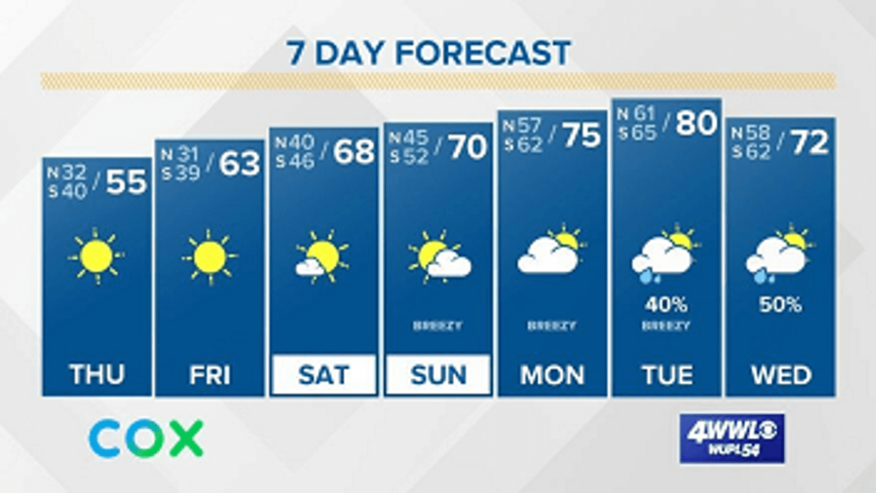
Here is a look at the 7 Day Forecast for the New Orleans area: WWLTV #lawx pic.twitter.com/I5KXqVchwY
— Dave Nussbaum WWL-TV (@Dave_Nussbaum) February 27, 2020Here is your detailed forecast:
THURSDAY:Sunny, breezy and chilly. Highs: 56. Wind N 6-12 mph.
TONIGHT:Clear and cold. Lows north: 33 with frost, and south: 39. Wind W 3-5 mph.
FRIDAY:Sunny, breezy and warmer. Highs: 65. Wind W 8-15 mph.
SATURDAY:Sunny and warmer. Lows north: 41 and south: 47. Highs: 68.
SUNDAY:Partly cloudy and warmer. Lows north: 47 and south: 52. Highs: 70.
MONDAY:Mostly cloudy, breezy and warmer with a 20% chance for a shower. Lows north: 57 and south: 62. Highs: 76.
TUESDAY:Mostly cloudy, breezy and warmer with a 30% chance for a shower. Lows north: 62 and south: 65. Highs: 80.
WEDNESDAY:A 40% chance for morning showers and storms, then mostly cloudy and mild in the afternoon. Lows north: 60 and south: 62. Highs: 74.