


Be prepared for rain, heavy at times, the next few days.
"A wet stretch begins today and continues through the weekend as deep tropical moisture moves across Southeast Louisiana," WWL TV Meteorologist Payton Malone forecasts. "Rain chances climb to 80 to 100 percent, with the heaviest and most persistent rain expected Saturday."
He says the New Orleans metro and coastal Louisiana and Mississippi, could pick up 3 to 5 inches of rain through the weekend with localized totals over 6 inches.
"Areas farther north should see less, generally 1 to 3 inches."
Localized flooding is a concern.
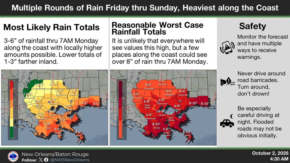 NWS
NWS
"Repeated rounds of rain gradually saturate the ground. Rainfall rates around an inch per hour could continue for several hours in some spots, especially Saturday."
Malone says minor coastal flooding will also be possible during high tide along south and east facing shorelines.
"Conditions should begin improving Monday as the front pushes offshore, with rain chances gradually dropping through the middle of next week."
Detailed Forecast...
TODAY:
Mostly cloudy. 50% scattered showers and storms. Iso. downpour could lead to localized flooding. Breezy. High: 90. Winds: SE/E 8-15.
SATURDAY:
90% heavy rain, storms at times. Isolated street/flash flooding. Low: S 76, N 72. High: 84.
SUNDAY:
60% heavy rain, storms at times. Isolated street/flash flooding. Low: S 75, N 71. High: 83.
MONDAY:
30% scattered showers, mainly south toward coast. Lingering clouds. Breezy, becoming less humid. Low: S 73, N 68. High: 82.
TUESDAY:
Partly cloudy, 20% mainly coastal showers. Breezy, less humid. Very nice! Low: S 71, N 64. High: 82.
WEDNESDAY:
Partly cloudy. 20% coastal showers. Less humid. Very nice! Low: S 71, N 63. High: 82.
THURSDAY:
Mostly sunny to partly cloudy. Mild, low humidity. Very pleasant! Low: S 71, N 63. High: 83.