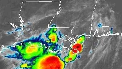
While we may have avoided a worst-case scenario, the tropical disturbance that's now over Louisiana could drop heavy rain over the state between now and tomorrow night.
In fact, Southeastern Louisiana remains under a flood watch through late Friday night. According to the National Weather Service, the area could see two to four inches of rain between now and then, with some areas receiving as much as six inches of rain.
Because it's now over land, the system is unlikely to become better organized. The system will continue to push to the northwest on Friday, bringing what will appear to be typical summer storms as it meanders out of the area. By Saturday, the system will be out of the area.
There's a slight chance the system could make a U-turn and bring more rain to the region by the middle of next week. However, forecast models are not in agreement that this will happen.
We can expect hot and dry conditions to return once the system clears out, with high temperatures in the mid 90s and heat indices in the triple digits.
THURSDAY:
80% chance passing showers and storms. Some heavy. Breezy at times. High: 87. Winds: N/E 5-10 mph.
FRIDAY:
70% chance passing showers and storms. Some heavy. Breezy at times. Low: S 75, N 74. High: 88.
SATURDAY:
Mostly cloudy. 60% chance scattered showers and storms. Low: S 75, N 74. High: 90.
SUNDAY:
Partly cloudy. 30% chance spotty showers and storms. Hot, humid. Low: S 76, N 75. High: 93.
MONDAY:
Partly cloudy. 20% chance isolated shower, storm. Hot, humid. Low: S 77, N 76. High: 94.
TUESDAY:
Partly cloudy. 20% chance isolated shower, storm. Hot, humid. Low: S 78, N 77. High: 95.
WEDNESDAY:
Partly cloudy. 60% chance scattered showers and storms possible. Hot, humid. Low: S 79, N 77. High: 93.