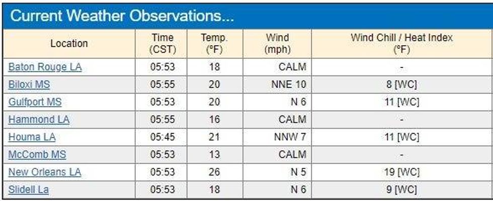
Despite even colder temps in many spots, there are no major road closures today in Southeast Louisiana.
The ice that shut down interstates, highways, bridges and overpasses yesterday is not a problem today.
Temps did drop to the teens and 20s across the area, with some single digit wind chills before dawn.
 NWS
NWS
After nearly all schools were closed yesterday, districts were split on holding classes today.
OPEN
· Jefferson Parish
· St. Charles Parish
· St. Bernard Parish
· Plaquemines Parish
CLOSED or virtual
· St. Tammany Parish
· Orleans Parish
· Tangipahoa Parish
· Lafourche Parish
· Terrebonne Parish
· St. John Parish
· St. James Parish
· Washington Parish
Things warm up today to the 40s.
"On Thursday temperatures will spring into the 60s as clouds increase and a few light showers move through with a weaker cold front," WWL TV Meteorologist Payton Malone forecasts.
"Colder air will follow, but we'll only drop into the 40s for Friday morning. Then we stay chilly with clearing skies Friday."
He says that cold air keeps spilling in for the weekend.
"Saturday and Sunday will bring hard freezes north of the lake and light freezes south. Afternoons will be mostly sunny but chilly in the 40s."
Detailed Forecast...
TODAY:
Morning hard freeze north and south of the lake. Mostly sunny and cold. Low: High: 44. Wind E/SE 5-10 mph.
THURSDAY:
Morning freeze north of the lake, light freeze or frost possible south of the lake. Mostly sunny and warmer. 30% chance of showers. Low: S 38, N 30. High: 64.
FRIDAY:
Mostly cloudy and breezy. Low: S 44, N 42. High: 50.
SATURDAY:
Morning hard freeze north, light freeze south. Sunny and chilly. Low: S 29, N 24. High: 42.
SUNDAY:
Morning hard freeze north, light freeze south. Partly cloudy and chilly. Low: S 32, N 23. High: 48.
MONDAY:
Mostly cloudy and warmer. Low: S 44, N 37. High: 60.