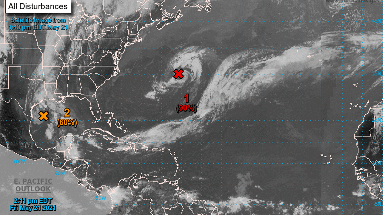
The National Hurricane Center is watching two areas of weather disturbances with a chance of developing into storms.
One tropical disturbance, already in the Gulf of Mexico, has a 60 percent chance of developing before moving over Texas.
The other system is in the Atlantic and has a 90 percent chance of developing into named storm Ana.
Here is what Hurricane Center forecasters are saying:
1. Showers and thunderstorms associated with a non-tropical low-pressure area centered about 300 miles northeast of Bermuda have diminished somewhat over the past several hours, and the system has not yet acquired subtropical storm characteristics. However, the low is producing gale-force winds, and any increase in organization would result in advisories being initiated on the system later today or tonight as it moves westward to west-southwestward to the northeast of Bermuda. Subsequently, the low is forecast to move northeastward into a more hostile environment by Saturday night or Sunday. Additional information on this low pressure area can be found in High Seas forecasts issued by the NOAA Ocean Prediction Center and forecast products, including a tropical storm watch, issued by the Bermuda Weather Service.
* Formation chance through 48 hours...high...90 percent.
* Formation chance through 5 days...high...90 percent.
2. Surface observations and recent satellite wind data indicate that a well-defined low-pressure system over the western Gulf of Mexico has winds of 30-35 mph near and east of the center. The associated shower and thunderstorm activity remains limited, but any increase in this activity may result in the formation of a short-lived tropical depression or storm before the system moves inland over the northwestern Gulf coast tonight and potential tropical cyclone advisories may be needed as early as this afternoon. Regardless of development, the system could produce heavy rainfall over portions of southeastern Texas and southwestern Louisiana through Saturday. Given the complete saturation of soils with ongoing river flooding along the Texas and Louisiana coastal areas, heavy rain could lead to flash, urban, and additional riverine flooding across this region. Additional information on the rainfall and flooding potential can be found in products issued by your local National Weather Service Forecast Office.
* Formation chance through 48 hours...medium...60 percent.
* Formation chance through 5 days...medium...60 percent.