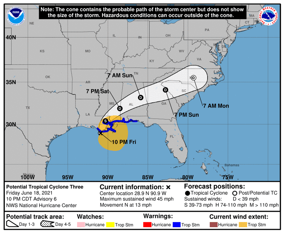
The National Hurricane Center says the low pressure system in the Gulf of Mexico has been getting organized as it moves within less than 100 miles of the Louisiana coast.
"There is still a high chance the system will become a tropical or subtropical storm through Saturday morning while the center is over or near water," according to Senior Hurricane Specialist Jack Bevin.
"The system is expected to begin weakening Saturday afternoon as it moves farther inland."
At 10:00pm maximum sustained winds were near 45 mph with higher gusts.
The Hurricane Center says, "On the forecast track, the system should move inland over Louisiana during the next several hours, then move across portions of the Gulf coast and southeastern states through the weekend."
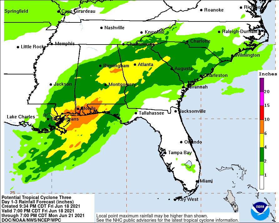
The worst of the rains are expected in Mississippi and Alabama.
HAZARDS AFFECTING LAND
----------------------
RAINFALL:
The potential tropical cyclone is expected to produce rainfall totals of 5 to 10 inches with isolated maximum amounts of 15 inches across portions of the Central Gulf Coast. Considerable flash, urban and small stream flooding impacts as well as new and renewed minor to isolated moderate river flooding are likely.
As the system continues to lift northeast through the weekend, heavy rain will expand across the interior Southeast and western Carolinas, resulting in rainfall totals of 3 to 6 inches with isolated maximum amounts of 8 inches. Flash, urban, small stream and isolated minor river flooding impacts are possible.
STORM SURGE:
The combination of storm surge and the tide will cause normally dry areas near the coast to be flooded by rising waters moving inland from the shoreline. The water could reach the following heights above ground somewhere in the indicated areas if the peak surge occurs at the time of high tide...
Morgan City, LA to Okaloosa/Walton County Line, FL...2-3 ft
Lake Borgne and Mobile Bay...2-3 ft
Lake Pontchartrain and Lake Maurepas...1-2 ft
Okaloosa/Walton County Line, FL to Panama City, FL...1-2 ft
Pensacola Bay, Choctawhatchee Bay, and Saint Andrew Bay...1-2 ft
Cameron, LA to Morgan City, LA...1-2 ft
Vermilion Bay...1-2 ft
WIND:
Tropical storm conditions should continue along the coast in the warning area through Saturday.
TORNADOES:
A few tornadoes are possible through Saturday across southeast Louisiana, southern Mississippi, southern Alabama, and the western Florida Panhandle into southwest Georgia.