The holiday weekend comes with summer heat and storms.
"This Labor Day weekend, expect hot conditions in the low 90s," WWL TV Meteorologist Payton Malone said.
He forecasts just a few hit or miss storms today.
"The chance for t-storms increases Saturday with more coverage. There will be plenty of breaks in the rain, but summertime popup storms are more likely on Saturday. If you get under one of these storms it will dump heavy rain. Same thing expected Sunday with a little less coverage of rain."
Malone advises that next week looks similar with popup storms possible in the afternoons and high temperatures in the upper 80s.
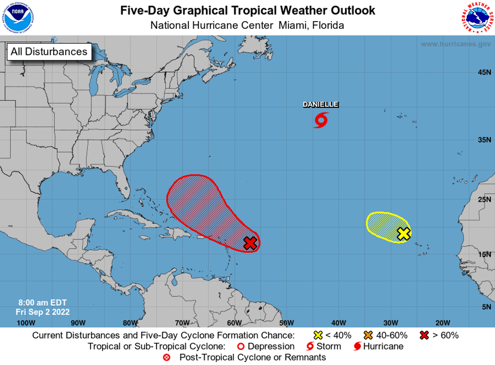
Meanwhile, in the tropics, things are picking up.
"Danielle continues to spin out in the middle of the Atlantic. It's no threat to land right now," Malone said of the named system in the northern Atlantic.
The National Hurricane Center says Danielle is forecast to be a hurricane over the Atlantic for the next five days.
 NHC
NHC
"Two other areas being highlighted by the NHC for potential development in the coming days, also not a threat to the US," Malone said.
Detailed Forecast...
TODAY:
Lots of sun, partly cloudy. 20-30% isolated to spotty storm. High: 93.
SATURDAY:
Mostly cloudy. 50% scattered showers and storms. Some heavy. Low: S 79, N 75. High: 88.
SUNDAY:
Mostly cloudy. 50% scattered showers and storms. Some heavy. Low: S 77, N 73. High: 88.
LABOR DAY:
Partly to mostly cloudy. 30-40% scattered showers and storms. Low: S 77, N 73. High: 90.
TUESDAY:
Partly cloudy. 30% spotty showers and storms. Hot and humid. Low: S 78, N 74. High: 91.
WEDNESDAY:
Partly cloudy. 30% spotty showers. Hot and humid. Low: S 78, N 74. High: 92.
THURSDAY:
Partly cloudy. 30% spotty showers. Hot and humid. Low: S 78, N 74. High: 92.