The National Hurricane Center says Tropical Storm Idalia will rapidly intensify in the Gulf of Mexico this week before slamming ashore in Florida.
"On the forecast track, the center of Idalia is forecast to pass near or over western Cuba tonight, over the extreme southeastern Gulf of Mexico by early Tuesday, and reach the Gulf coast of Florida on Wednesday," the NHC advised.
The forecast calls for sustained winds over 115mph by the time Idalia makes landfall.
"Idalia is forecast to become a hurricane later today and a dangerous major hurricane over the northeastern Gulf of Mexico by early Wednesday."
Hurricane Warnings and Watches are in effect in Florida and Cuba.
The Hurricane Center is also warning of storm surge with "a possibility of life-threatening inundation, from rising water moving inland from the coastline."
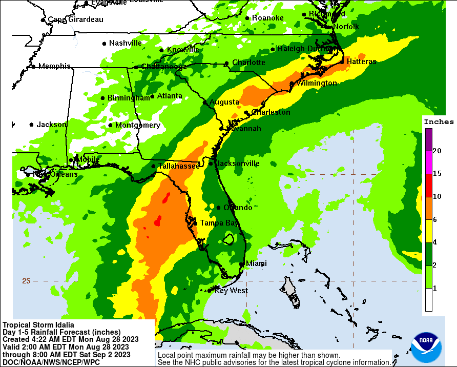
Flooding rain are also a big concern.
 NHC
NHC
HAZARDS AFFECTING LAND
----------------------
STORM SURGE: The combination of a dangerous storm surge and the tide will cause normally dry areas near the coast to be flooded by rising waters moving inland from the shoreline. The water could reach the following heights above ground somewhere in the indicated areas if the peak surge occurs at the time of high tide...
Aucilla River, FL to Chassahowitzka, FL...7-11 ft
Chassahowitzka, FL to Anclote River, FL...6-9 ft
Ochlockonee River, FL to Aucilla River, FL...4-7 ft
Anclote River, FL to Middle of Longboat Key, FL...4-7 ft
Tampa Bay...4-7 ft
Middle of Longboat Key, FL to Englewood, FL...3-5 ft
Englewood, FL to Chokoloskee, FL...2-4 ft
Charlotte Harbor...2-4 ft
Indian Pass, FL to Ochlockonee River, FL...2-4 ft
Chokoloskee, FL to East Cape Sable, FL...1-3 ft
Florida Keys...1-2 ft
The deepest water will occur along the immediate coast in areas of onshore winds, where the surge will be accompanied by large and dangerous waves. Surge-related flooding depends on the relative timing of the surge and the tidal cycle, and can vary greatly over short distances. For information specific to your area, please see products issued by your local National Weather Service forecast office.
Storm surge will raise water levels by as much as 4 to 6 feet above normal tide levels along the southern coast of Pinar del Rio, Cuba. Near the coast, the surge will be accompanied by large waves.
WIND: Hurricane conditions are expected within the hurricane warning area in western Cuba later today. Winds are expected to first reach tropical storm strength by this morning, making outside preparations difficult or dangerous. Preparations to protect life and property should be rushed to completion.
Tropical storm conditions are expected over portions of the tropical storm warning area over the Yucatan Peninsula and the Isle of Youth in Cuba through today.
Hurricane conditions are possible within the hurricane watch area by late Tuesday or Wednesday, with tropical storm conditions possible by Tuesday.
Tropical storm conditions are possible in the Dry Tortugas beginning late today and within the tropical storm watch area along the Florida Gulf coast on Tuesday.
RAINFALL: Idalia is expected to produce the following rainfall amounts:
Portions of the eastern Yucatan: Additional 1 to 2 inches.
Western Cuba: 4 to 7 inches, with isolated higher totals of 10 inches.
Portions of the west coast of Florida, the Florida Panhandle, southeast Georgia and the eastern Carolinas: 4 to 8 inches from Tuesday into Thursday. Isolated higher totals of 12 inches possible, primarily near landfall in northern Florida.
This rainfall may lead to flash and urban flooding, and landslides across western Cuba. Areas of flash and urban flooding, some of which may be locally significant, are expected across portions of the west coast of Florida, the Florida Panhandle, and southern Georgia Tuesday into
Wednesday, spreading into portions of the eastern Carolinas Wednesday into Thursday.
SURF: Swells generated by Idalia are affecting portions of the southern coast of Cuba and eastern Yucatan. These swells are likely to cause life-threatening surf and rip current conditions. Please consult products from your local weather office.