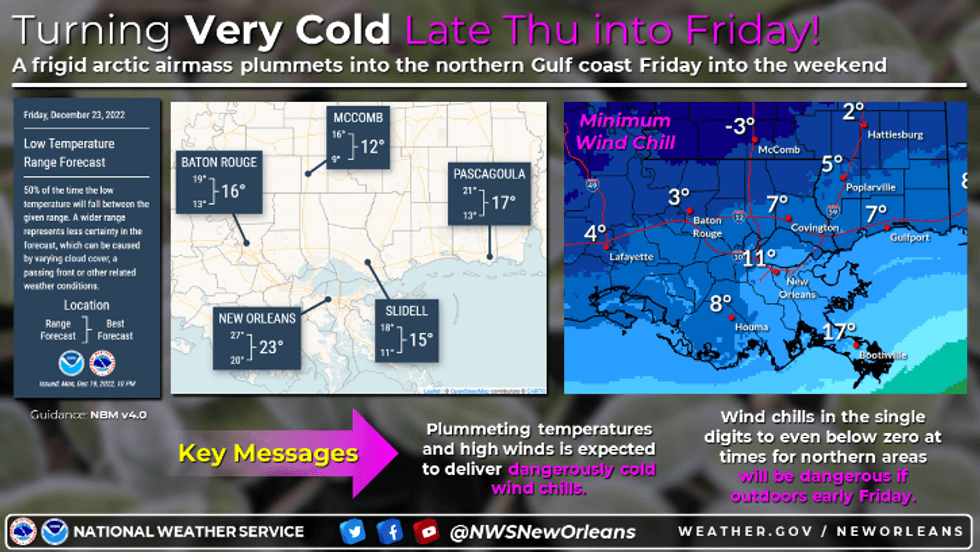
The surge of frigid air is set to arrive in the New Orleans area Thursday evening. WWL TV Meteorologist Payton Malone says after highs in the mid 60s Thursday afternoon, temps start plummeting around 6:00pm. By Friday morning, areas across the region will be 40 to 50 degrees colder.
 NWS
NWS
We still have time to get ready.
"Today will be cool and cloudy. High temperatures stay in the low to mid 50s, but fortunately it looks dry for those that need to do any cold weather preparations. Thursday should be an okay day to do preparations. We'll warm into the mid 60s with a few showers possible Thursday evening. The cold front will then blast through Thursday evening."
 NWS
NWS
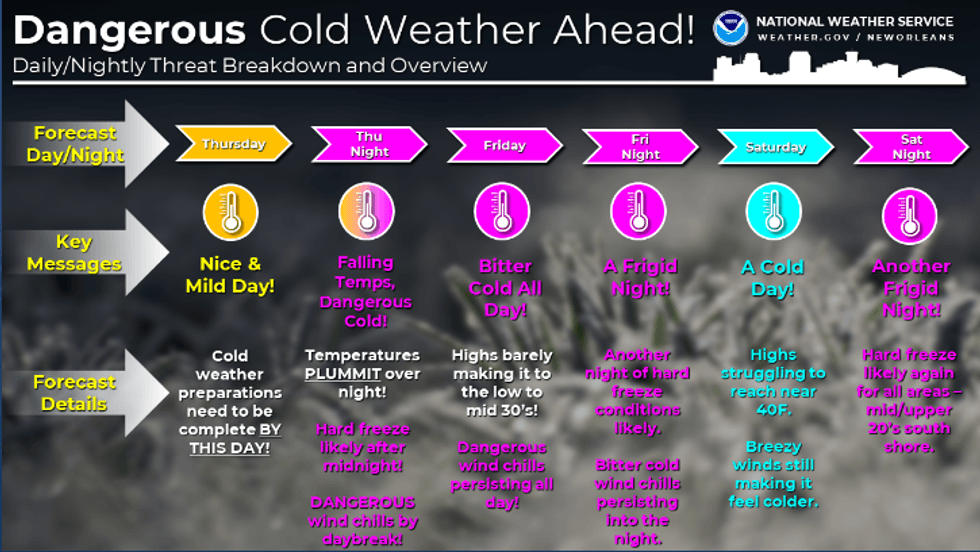
Malone says the good news is that ice and snow are not expected to be an issue.
"Here's what we DON'T need to worry about this weekend: ice on roads or snow accumulations. IF we were to see a wintry mix it should be light and quick enough to not cause any big problems. It's possible a few snow flurries mix in Thursday night."
He says it will be blustery though.
"Strong winds could make for driving issues Friday and wind chills will be in the teens and even some single digits. So good idea to just stay indoors!"
Malone says take this time to get everything in order.
"Preparation is key and we will get to that hard freeze range, low to mid 20s, where pipes will be an issue Friday morning. We could get above freezing for a few hours Friday afternoon, though not everyone...mainly on the Northshore and farther north."
He forecasts another hard freeze Christmas Eve morning and again Christmas morning, through it may not be as bad on the Southshore, more upper 20s. Likely a 4th morning of a hard freeze on the Northshore and Mississippi Monday morning, but likely just near freezing South.
"A warming trend will likely take us toward New Year's Eve weekend. So the Arctic Blast should only last about 4 days, but for many that will be enough!"
Detailed Forecast:
TODAY:
Mostly cloudy and chilly. High: 54. Winds: N/NE 6-12.
THURSDAY:
Mostly cloudy. 30% isolated shower. Milder temps. Low: S 51, N 46. High: 65.
FRIDAY:
Arctic outbreak! Wind chill Advisory likely, Hard Freeze for most areas. WINDY! Low: S 26, N 20. High: 34, feeling like teens.
CHRISTMAS EVE:
HARD FREEZE. Cold and breezy. Mostly sunny. Low: S 23, N 18. High: 39.
CHRISTMAS:
HARD FREEZE North. Cold and breezy. Mostly sunny. Low: S 27, N 19. High: 42.
MONDAY:
HARD FREEZE North. Chilly and mostly sunny to partly cloudy. Low: S 32, N 25. High: 53.
TUESDAY:
Mostly sunny. Chilly morning, no freezes. Cool afternoon. Low: S 44, N 36. High: 58.