After some morning rain and gloomy conditions, we should see some sunshine breaking through this afternoon.
"Most of this should clear by the late morning and the afternoon looks mostly dry," WWL TV Meteorologist Payton Malone forecasts. "Highs warm into the mid and then upper 70s for Tuesday and Wednesday before a cold front arrives."
He says today's high will near the record of 79 degrees.
When does the colder air get here?
"The timing of the front and any rain along the front looks to be early Thursday morning, with cooler and less humid air arriving through the day Thursday and Friday," Malone explained.
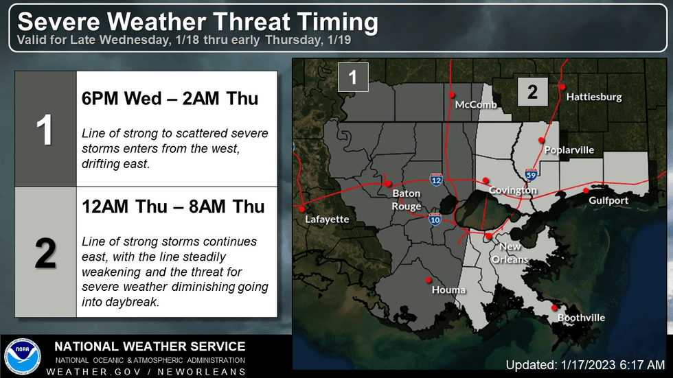 NWS
NWS
He says we will see more normal weather for this time of year by the end of the week.
"The weekend will see an upper disturbance begin increasing clouds and triggering scattered showers for Saturday and Sunday. Not a complete wash-out, but certainly periods of rain. Temperatures will be cool in the upper 50s/lows 60s this weekend."
Detailed Forecast...
TODAY:
Morning showers then drier. Warmer, humid. High: 77. Winds: S 6-12.
WEDNESDAY:
Mostly cloudy. 20% spotty showers, more overnight. Breezy. Warm and humid. Low: S 66, N 63. High: 77.
THURSDAY:
Early AM rain, then clearing. Turning cooler, less humid. Low: S 61, N 58. High: 70.
FRIDAY:
Sunny. Cooler and less humid. Increasing clouds late. Low: S 51, N 43. High: 60.
SATURDAY:
60% scattered showers, some storms. Mild. Low: S 53, N 46. High: 59.
SUNDAY:
60% scattered showers, some storms. Mild, falling temps late. Low: S 56, N 54. High: 62.
MONDAY:
Some early clouds, then sunny. Cooler, less humid. Low: S 48, N 42. High: 60.