


The devastating Palisades Fire continues to grip the region, forcing thousands from their homes as evacuation orders have been dramatically expanded Friday.
Tune in to KNX News for the latest.
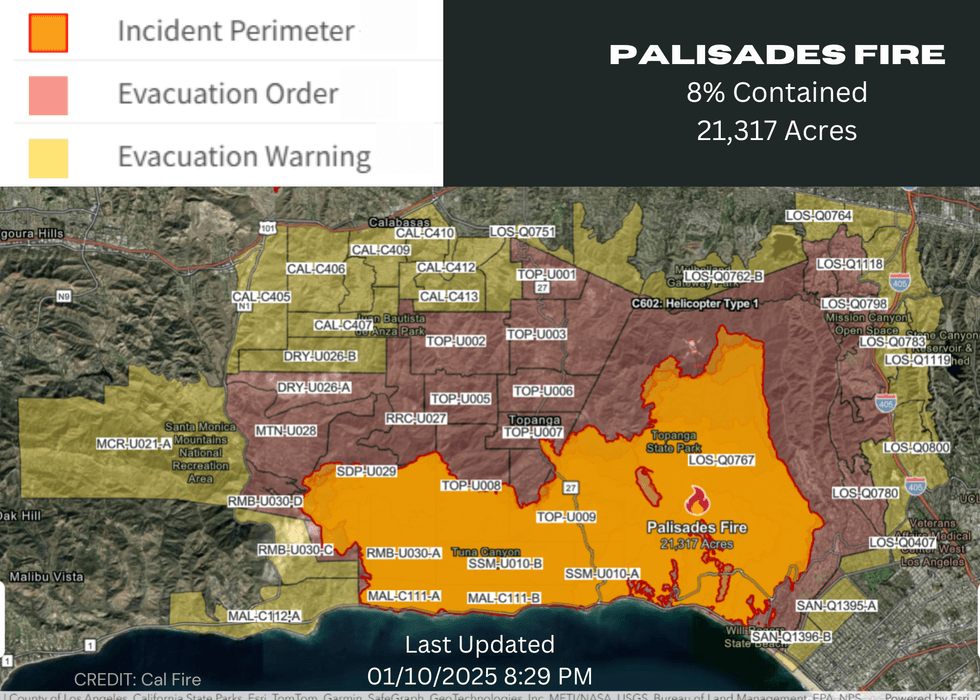
Friday evening, the fire was estimated at 21,317 acres with only 8% containment, and made a strong push to the northeast, prompting evacuation warnings that stretched as far east as Sepulveda Boulevard, essentially reaching the San Diego (405) Freeway and extending north toward Encino.
Urgent evacuations for residents from Sunset Boulevard to Encino Reservoir and from the 405 west to Mandeville Canyon.
 Cal Fire
Evacuation centers have been established at:
Lanark Recreation Center
21816 Lanark St
Conoga Oark, CA 91304
Van Nuys Recreation Center
14301 Vanowen St
Van Nuys, CA 91405
Calvary Community Church
5495 Via Rocas
Westlake Village, CA 91362
El Camino Real Charter High School (Relocated to Ritchie Valens Recreation Center below)
5440 Valley Circle Boulevard
Woodland Hills, CA 91367
Ritchie Valens Recreation Center
10736 Laurel Canyon Boulevard
Pacoima, CA 91331
Pasadena Convention Center
300 E Green Street
Pasadena, CA 91101
Stoner Recreation Center
1835 Stoner Ave
Los Angeles, CA 90025
Westwood Recreation Center
1350 South Sepulveda Boulevard
Los Angeles, CA 90025
Pan Pacific Recreation Center
7600 Beverly Boulevard
Los Angeles, CA 90036
Pomona Fairplex (Gate 3)
601 W McKinley Ave
Pomona, CA 91768
The fire has wreaked havoc across the region, destroying homes, businesses, and iconic landmarks. The death toll remains at five, and officials warn that this number is likely to rise.
Firefighters are battling the blaze tirelessly on the ground and from the air, but the fire's unpredictable behavior has made containment efforts difficult.
A Cal Fire aerial survey on Thursday determined that about 5,316 structures may have been destroyed by the fire. Those "structures" could include residential and commercial properties and smaller structures such as RVs, sheds or other "minor buildings."
"It is safe to say the Palisades Fire is one of the most destructive natural disasters in the history of Los Angeles," LAFD Chief Kristin Crowley said during a Thursday morning briefing.
Video from the fire zone painted pictures of total devastation, with flames jumping from home to home, structure to structure throughout the Palisades area.
The cause of the fire was unknown. It erupted amid fierce Santa Ana winds that forecasters called the worst windstorm in the Southland in a decade. The peak gusts of the wind event slammed the fire area between 10 p.m. Tuesday and early Wednesday morning, though red flag warnings of critical fire danger were expected to be in place until Friday evening.
Mandatory evacuation orders were issued across a wide area generally stretching from Kenter Avenue on the east, Mulholland Drive on the north, Topanga Canyon Boulevard on the west and the Pacific Ocean on the south.
Los Angeles County Fire Department Chief Anthony Marrone said there were a "high number of significant injuries to residents who did not evacuate, in addition to first responders who were on the fire lines."
When the fire began expanding to the east, Santa Monica issued a mandatory evacuation order for all residents north of Montana Avenue from the ocean to 11th Street, and north of San Vicente Boulevard between Ocean Boulevard and 26th Street. An evacuation warning was issued for all other residents north of Montana Avenue. Those orders were amended Friday, with the mandatory order impacting only areas north of San Vicente. All properties between San Vicente and Montana Avenue were under an evacuation warning, while the warning between Montana and Wilshire boulevard was lifted.
The city of Malibu also issued evacuation orders as the flames advanced into that city.
Evacuation centers were established at the Westwood Recreation Center, Pasadena Convention Center and at El Camino Real Charter High School in Woodland Hills.
Large animals can be taken to Pierce College in Woodland Hills or the Los Angeles Equestrian Center in Burbank. Small animals can be taken to the Agoura Animal Care Center and Pasadena Humane Society.
Pacific Coast Highway remains closed north of the McClure Tunnel and through the fire area. The westbound Santa Monica (10) Freeway remains closed at Lincoln Boulevard.
Los Angeles County Board of Supervisors Chair Kathryn Barger signed an emergency proclamation in response to the fire, and the city of Los Angeles also issued an emergency declaration. Gov. Gavin Newsom later signed a state of emergency proclamation.
Newsom, noting that President Joe Biden was in the Los Angeles area when the fire erupted, said Biden had given approval to federal funding to help cover costs of the firefighting effort. Biden announced Thursday that the emergency funding, which normally covers 75% of costs relating to firefighting and recovery efforts, will cover 100% of the costs for 180 days.
City News Service has contributed to this article.
Follow KNX News 97.1 FM
Twitter | Facebook | Instagram | TikTok


