MIAMI (AP) — Tropical Storm Raymond, the third system now off the western coast of Mexico, formed Thursday in the eastern Pacific Ocean.
The U.S. National Hurricane Center in Miami said Raymond was about 115 miles (190 kilometers) south-southeast of Zihuatanejo, Mexico. It had maximum sustained winds of 45 mph (75 kph) and was traveling west-northwest at 14 mph (22 kph).
At the same time, Tropical Storm Priscilla remained off the western coast of Mexico and was bringing rain to the Baja California peninsula.
The former tropical storm Octave also churned in the eastern Pacific near Mexico but was downgraded Thursday morning to a post-tropical cyclone and was expected to dissipate soon.
THIS IS A BREAKING NEWS UPDATE. AP’s earlier story follows below.
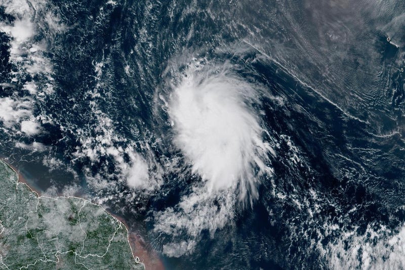
MIAMI (AP) — Tropical Storm Jerry churned Thursday in the Atlantic on its approach to the Leeward Islands as Tropical Storm Priscilla moved along Mexico’s Pacific coast, threatening heavy rain and flooding in their paths, forecasters said.
Priscilla could bring flash flooding through the weekend across the U.S. Southwest, the U.S. National Hurricane Center in Miami said.
And off the southeast U.S. coast, a storm without a name along with unusually high King Tides because the moon is closer than usual to the Earth threatened to bring days of heavy winds that could cause coastal flooding, especially along the vulnerable North Carolina Outer Banks and in frequently flooded Charleston, South Carolina.
Tropical Storm Jerry to move past the Leeward Islands
Jerry was centered about 310 miles (495 kilometers) east-southeast of the northern Leeward Islands and moving west-northwest at 18 mph (30 kph) with maximum sustained winds of 65 mph (105 kph), the center said.
The storm was expected to pass near or to the northeast of the northern Leeward Islands on Thursday night.
Officials in the French Caribbean island of Guadeloupe warned of power outages on Thursday, noting the island’s grid is grappling with power generation issues that began earlier this week and that inclement weather would worsen them.
A tropical storm warning was in effect for Barbuda with a tropical storm watch issued for Antigua, Anguilla, St. Kitts, Nevis and Montserrat, St. Barts and St. Martin, Saba and St. Eustatius and Guadeloupe and the adjacent islands, the National Hurricane Center said.
The storm should strengthen into a hurricane late Friday. The Nor'easter expected to send rain and pounding waves into the Southeast U.S. is helping steer Jerry away from the islands and into the open Atlantic, forecasters said.
Coastal storm to bring flooding tides to southeast US coast
In Charleston, the combination of the coastal storm and the higher King Tides have forecasters predicting a high tide Friday morning of 8.5 feet (2.6 meters). That would be the 13th highest tide at the gauge in Charleston Harbor, which has been recording data for more than a century.
The city offered free parking in some garages starting Thursday morning when the tide was 0.6 feet (18 centimeters) below Friday's forecast but still flooded about a dozen streets.
Along the North Carolina Outer Banks, forecasters said the worst weather should start Friday through the weekend and they warned it was likely that highway N.C. 12 on Hatteras and Ocracoke islands would likely have to close again because of ocean overwash.
More homes could fall into the sea too. Twenty-one houses have collapsed because of rising sea levels and shifting beaches since 2020 with 10 of them destroyed by the churning waters in the past month as Hurricanes Humberto and Imelda moved well offshore, according to the National Park Service.
More storms in the Pacific
In the Pacific, Priscilla was centered about 165 miles (265 kilometers) west-southwest of the southern part of Baja California and moving north-northwest at 8 mph (13 kph) with maximum sustained winds of about 45 mph (75 kph).
Priscilla had approached major hurricane status Tuesday before weakening to a tropical storm on Wednesday.
The storm is expected to move into the southwestern U.S. as it weakens further and flood watches have been issued for parts of Arizona, California and Nevada.
A tropical depression formed Thursday about 115 miles (185 kilometers) off the southwestern Mexican coast, prompting a tropical storm watch. It is predicted to move just offshore and not get past tropical storm strength.
Meanwhile, the former tropical storm Octave dissipated Thursday about 360 miles (580 kilometers) off the southern tip of Baja California, the hurricane center said.