Welcome to August! We're so happy July is gone, this means we only have to worry about August and the first part of September before we start to cool down. Unfortunately, August will start off hot! We do have some subtle changes coming by early next week. a brief break in the heat and possibly some rain.
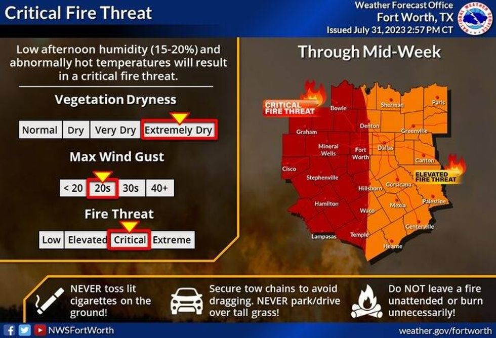
Before the subtle weather change arrives, we have to deal with blistering heat, a grass fire danger, near record-breaking heat and Excessive Heat Warnings through the weekend.
Today's record high is 107°. We'll come close to tying or breaking that today. Surface temperatures will jump up to near 107 degrees, tomorrow through Sunday as well. Some areas will be a degree or two cooler, other areas will be a degree or two higher. The good news is we don't have to deal with high heat index values. The humidity levels will remain low during the afternoon hours. Bad news is, the grass fire danger will continue at least through Saturday.
 National Weather Service - Fort Worth
By Sunday night, a cold front will be approaching the area. There will be some scattered showers and storms trying to sneak in overnight into Monday morning. More rain chances are in the forecast for Monday afternoon and evening as well as Tuesday of next week. Afternoon highs will be near average with readings topping out in the mid-90s.
 National Weather Service - Fort Worth
*Yest Rain: 0.00"; Yest High: 105 Low: 80
*Today's Averages: High: 97; Low: 77
*Record high: 107 (2011): Record low: 63 (1936)
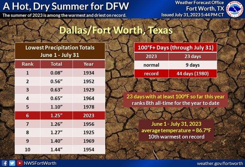
*July Rain: 0.47"; Deficit: 1.61"
*2023 Rain: 14.83"; Deficit: 7.54"
*Sunrise: 6:42am; Sunset: 8:27pm
Today: *Excessive Heat Warning* Mostly sunny, near record heat. Record: 107. High: 107. Grass fire danger. Wind: South 10-15 mph.
Tonight: Clear and warm. Low: 78-82. Wind: South 10-15 mph.
Wednesday: *Excessive Heat Warning* Mostly sunny and hot. High: 107. Grass fire danger. Wind: South 10-20 mph.
Thursday and Friday: *Excessive Heat Warnings likely* Sunny, breezy, and hot. Grass fire danger. High: 107.
Saturday: *Excessive Heat Warnings likely* Partly cloudy and hot. High: 108.
Sunday: *Excessive Heat Warnings likely* Partly cloudy, continued hot. Late evening cold front brings a chance of rain after midnight? High: 107.
Monday: Partly cloudy and cooler. Scattered late day showers and storms. High: Mid 90s.

LISTEN on the Audacy App
Tell your Smart Speaker to "PLAY 1080 KRLD"
Sign Up to receive our KRLD Insider Newsletter for more news