


We're waking up to slightly cooler temperatures under a mostly cloudy sky. Readings have fallen into the low to mid sixties north and west of DFW, upper sixties in the Metroplex.
Slightly lower humidity today under a partly cloudy sky. Afternoon highs will reach the low eighties.
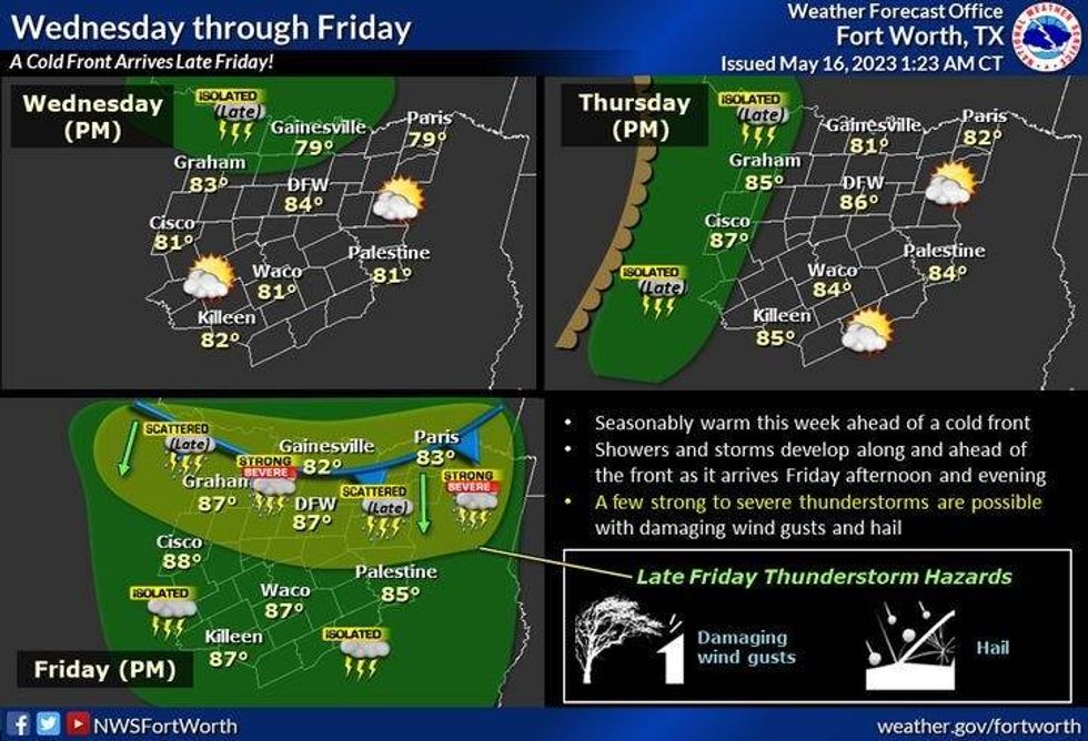
Our warm up starts tomorrow, as afternoon highs reach the mid eighties. There's also a very slight chance of some storms well to the NW of DFW by evening. We stay dry.
 National Weather Service - Fort Worth
The warm up continues into Thursday with highs in the mid to upper eighties, with morning clouds and afternoon sun. There will be some strong thunderstorms well to the west of us developing along the dryline by late Thursday afternoon and evening. These will be moving to the east, but will die out well before they reach the DFW area.
Friday will start off cloudy, with peaks of afternoon sunshine. A bigtime warm up as well, as readings reach the lower nineties! Now as we all know, we don't want that much heat out and ahead of a strong cold front, but that's the setup for Friday evening. Strong and severe thunderstorms will form in southern Oklahoma close to dinnertime and move through the area before midnight. Damaging wind and moderate size hail will be the threats. But please remember, isolated tornadoes can form at any time within a severe thunderstorm.
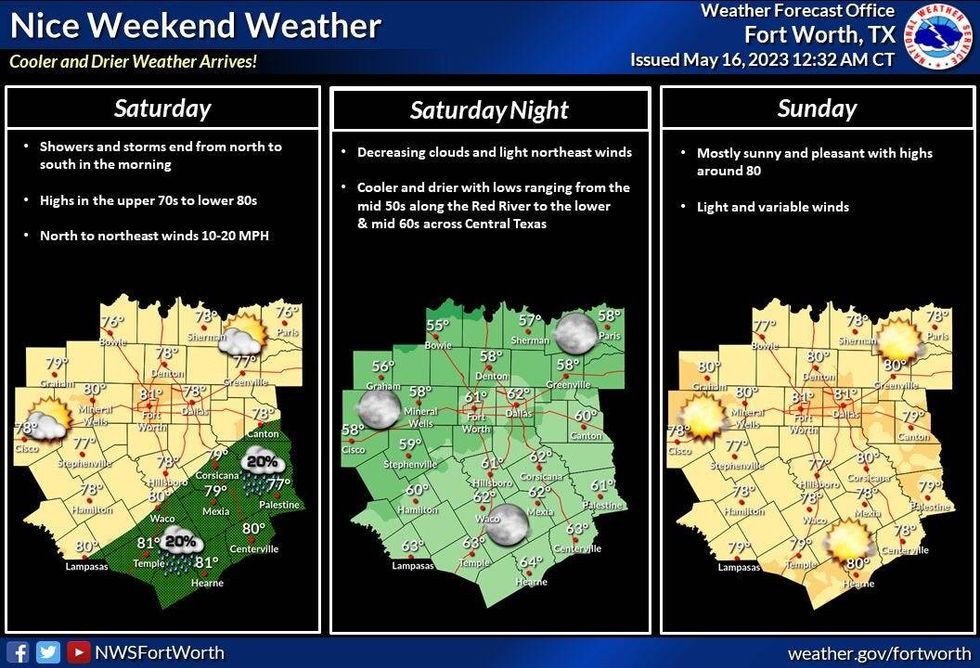
Storms will be gone by Saturday morning as a northerly wind takes over. This will usher in slightly drier air and cooler temperatures for the weekend. Partly cloudy Saturday with highs and mid seventies, upper seventies for Sunday, low eighties for Monday with plenty of sunshine.
 National Weather Service - Fort Worth
*Yest Rain: Trace; Yest High: 87; Low: 68
*Today's Averages: High: 83; Low: 65
*Record high: 94 (2003): Record low: 46 (1945)
*May Rain: 1.07"; Deficit: 1.24"
*2023 Rain: 12.30"; Deficit: 1.82"
*Sunrise: 6:29am; Sunset: 8:21pm
Today: Morning clouds, afternoon sun. Slightly lower humidity. High: Low 80s. Wind: NNW 5-10 mph.
Tonight: Partly cloudy and mild. Low: Mid to upper 60s. Wind: North 5-10 mph.
Tomorrow: Partly cloudy and a bit warmer. Isolated late day storms along the Red River. High: Mid 80s.
Thursday: Mostly to partly cloudy and warm. Isolated late evening storms to the west of Hwy 281. High: Mid to upper 80s.
Friday: Increasing clouds by late afternoon and hot. Scattered strong to severe by mid evening along our next cold front. High: Low 90s.
Weekend: Partly cloudy, cooler with lower humidity! Highs: Mid to upper 70s.
Monday: Mostly sunny, continued nice. High: Low 80s.

LISTEN on the Audacy App
Tell your Smart Speaker to "PLAY 1080 KRLD"
Sign Up and Follow NewsRadio 1080 KRLD
Facebook | Twitter | Instagram


