
AFTER A VERY RAINY WEEKEND ACROSS NORTH TEXAS… MOTHER NATURE’S PAYBACK IS HERE!
Yep… we all have to head back to work and school! But the good news is, look outdoors this morning and you’ll be looking at some beautiful weather for most of the week!
Cool mornings, warm afternoons and LOW humidity will be the story, especially during the afternoon hours. If you haven't made it out to the State Fair of Texas yet, this would be a pretty good week to do it!
GOOD MORNING, MY FRIENDS — WELCOME TO MONDAY!
And WOW… we certainly got some welcome rain across North Texas!
DFW Airport picked up more than 3½ inches of rain through the weekend.
Around Athens, Texas — roughly 70 miles southeast of Dallas — more than 10 inches of rain fell in a very short period of time.
Surrounding areas of Kaufman and Henderson counties also experienced significant flooding, and there are still other flood warnings across portions of Texas.
Thankfully, that system has now moved away.
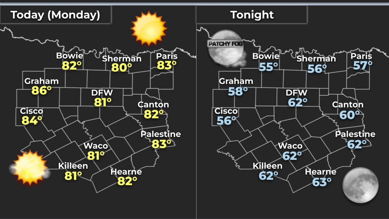
THIS MORNING: We're waking up to temperatures in the 60s across North Texas.
You can definitely feel the difference when you step outside, whether you're heading out the door for work or taking the dog for a morning walk.
The ground is SATURATED after several days of rain, so it's going to take some time to dry out.
And if you have a sprinkler system set to automatic, GO AHEAD AND SHUT IT OFF FOR A WHILE! You certainly won't need it after that soaking rain.
Our plants, shrubs, flower beds and lawns are LOVING all this water!
HERE COMES THE NICE WEATHER!
High pressure is nosing its way in from the Midwest, building from northeast to southwest and keeping us cooler and drier.
Lower dew points mean lower humidity!
That will be the story for most of the week.
Afternoon temperatures will still warm up nicely because the sun angle is still relatively high in the sky.
TODAY: Low 80sTUESDAY: Low 80sWEDNESDAY: Around the low 80s
In the city, mornings will generally be in the 60s, while some of the rural areas could drop into the 50s over the next few mornings.
Winds will be light — generally from the east-northeast today, gradually becoming more southeasterly by Wednesday.
LOOKING AHEAD TO THE END OF THE WEEK
Humidity will begin to creep back up just a little bit by the end of the week and into the weekend.
There's also another system — the remnants of a dying hurricane crossing Mexico — that could bring some additional moisture into the region.
Right now, most of that moisture looks like it will stay SOUTH of the Dallas-Fort Worth area, so we're not expecting a major impact here.
The National Hurricane Center is also monitoring an area of disturbed weather in the Bay of Campeche, well south of the Texas coast.
Right now, there's about a 30% chance of development over the next 48 hours and a 70% chance over the next week.
If it does develop, current indications are that it would head northeastward and away from the Texas coast. We'll keep watching it.
YOUR WEEKEND
Overall, the weekend looks warm and dry.
Friday: Mid 80s, with a few upper 80s possible
Saturday: Warm
Sunday: Could see some upper 80s
Morning lows should remain mainly in the 60s.
And then…
THE NEXT BIG COLD FRONT?
Not this week!
But NEXT WEEK could bring us our coolest front of the season so far.
So enjoy this beautiful weather while you've got it!
Because remember… it's the only weather you've got!
Have a GREAT Monday, everybody!
— Dan the Weatherman
7-Day Headlines:
- DFW Airport hit 78 degrees on Sunday; 0.17” of rain
- A dry week ahead
- Cool mornings/warm afternoons
- Low humidity all week
- Watching the Gulf for tropical development this weekend
- Great week to hit the State Fair of Texas
- Sunshine for all of you!!
- Download our AUDACY app! Listen to KRLD LIVE at home or at work
Almanac:
- Yest Rain: 0.00”; Yest High: 78; Low: 70
- Today’s Averages: High: 83; Low: 61
- Record high: 97 (1937); Record low 44 (1902)
- October rain: 3.84” ”; Surplus: 3.42”
- 2026 Rain: 26.62”; Snow: 2.4”; Deficit: <1.07”>
- Sunrise: 7:26am; Sunset: 7:06pm
Forecast:
Monday: Sunny and perfect! Low humidity! High: Low 80s. Wind: NE 5-10 mph.
Monday night: Clear and cool. Low: 57-63. Wind: ENE 5-10 mph.
Tuesday: Clear and seasonable. High: Low 80s. Wind: ENE 5-10 mph.
Wednesday - Friday: Mostly sunny and warm. High: Mid 80s.
Weekend: Mostly sunny and warm. High: Upper 80s.
LISTEN on the Audacy App
Tell your Smart Speaker to "PLAY 1080 KRLD"
Sign Up to receive our KRLD Insider Newsletter for more news
Follow us on Facebook | Twitter | Instagram | YouTube