A chilly start, a warming trend, no precipitation, and a historic blizzard unfolding in the northeastern United States. Those are your weather stories on this chilly Monday morning.
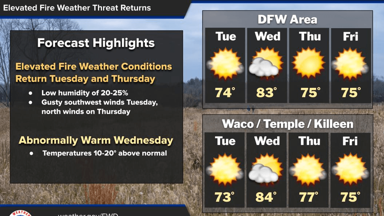
Good morning, everyone. I hope you had a great weekend and enjoyed the cooler temperatures. I have some good news for you: temperatures are expected to rise rapidly this week. We are waking up to temperatures in the upper 20s to mid-30s at this hour with a light north wind. Today is expected to be an excellent day with afternoon highs in the upper 50s, which is still a few degrees below average for this time of year.
A south wind returns overnight tonight and picks up significantly tomorrow as our warming trend begins. South winds will gust up to 30 mph during the day. We will start off Tuesday morning with lows between 35 and 40 degrees. Afternoon highs will reach the low 70s. It will be a perfect day, if you don't mind the wind.
Our warming trend continues into Wednesday with plenty of sunshine. South winds will blow at 10 to 20 mph, and temperatures will reach the lower 80s. That's about 20 degrees above average for this time of year.
A cold front will slide through the area before noon on Thursday, but unfortunately, no rain will accompany the front. It will knock temperatures down a few degrees, with afternoon highs in the mid-70s. We can expect a similar forecast for Friday. South winds return this weekend, and we warm up again. There will be plenty of sunshine, with afternoon highs reaching the lower 80s. Morning lows will be in the 50s.
In other news, a historic blizzard continues to pummel the northeastern United States. Snowfall totals of 12 to 24 inches are possible, with higher totals expected in eastern parts of Long Island, Connecticut, Rhode Island, and eastern Massachusetts over the next 12 hours. This storm system also contains wind gusts of 50 to 70 mph, with blizzard conditions continuing through this evening. This has crippled airports, but the blizzard will continue to move away from the Northeast by this evening.
Have a great day today, and please enjoy the weather when you can, it's the only weather you've got!
LISTEN on the Audacy App
Tell your Smart Speaker to "PLAY 1080 KRLD"
Sign Up to receive our KRLD Insider Newsletter for more news
Follow us on Facebook | Twitter | Instagram | YouTube
7-Day Headlines:
* DFW Airport reached 57 yesterday.
* Below average temperatures today.
* Quick warm up through Wednesday.
* Weak Thursday cold front.
* No rain for a while.
* Warming back up this weekend.
*Yest Rain: 0.00"; Yest High: 57; Low: 36
*Today's Averages: High: 63; Low: 42
*Record high: 88 (2017); Record low 16 (1901)
*February rain: 1.31"; Deficit:
*2026 Rain: 2.24"; Snow: 2.4" Deficit:
*Sunrise: 7:02am; Sunset: 6:21pm
Monday: A chilly stay, a cool end. Ample sunshine! High: Mid to upper 50s. Wind: NE 5-10 mph.
Monday night: Clear and chilly. Low: 32-38. Wind: South 5 mph.
Tuesday: Sunny, windy and warmer. High: Low 70s.
Wednesday: Sunny, breezy and warm. High: Near 80.
Thursday and Friday: Mostly sunny, a tad cooler. High: Mid 70s.
Weekend: Mostly sunny and warm. Highs: Low 80s.