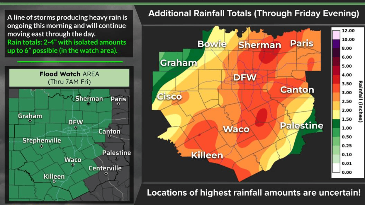

NORTH TEXAS RAIN UPDATE — FLOODING IS THE BIGGEST THREAT!
Good morning, North Texas! A large area of non-severe thunderstorms is slowly drifting east and will impact your morning commute across the region. The rain will continue through the late morning and into the early afternoon.
THE GOOD NEWS: So far, we have NOT seen severe weather across North Texas this morning. The biggest concern continues to be HEAVY RAIN AND FLOODING.
RED RIVER COUNTIES: Areas around Bowie and Montague have already picked up more than 6 inches of rain since mid-evening Wednesday! More rain is still coming, with another 1–2 inches possible before the rain finally tapers off later this morning.
HAVEN'T SEEN MUCH RAIN YET? Don't worry — it's coming! This system is moving VERY slowly.
TIMING ACROSS NORTH TEXAS:
• Denton, Fort Worth & Granbury: After 6:00 AM
• McKinney, Dallas & Waxahachie: Around 6:30–7:00 AM and beyond
• Rain will continue for much of the morning.
RAINFALL TOTALS BY NOON: Many locations could see 2–3 inches, with isolated higher totals possible. Some areas will see much less, while others could pick up several inches.
FLOOD WATCHES remain in effect through Friday morning.
And we're NOT done yet! Another area of showers and thunderstorms will develop ahead of the cold front later tonight and move through North Texas during the day Thursday. An additional 1–2 inches of rain will be possible.
Right now, it appears areas along and south of I-20 could receive somewhat heavier rainfall Thursday, but it's still too early to pinpoint exactly where the heaviest pockets will develop.
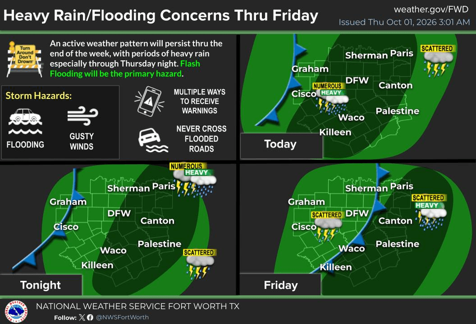
PLEASE REMEMBER: TURN AROUND, DON'T DROWN!
Water-covered roadways can be extremely dangerous, especially when you don't know how deep the water is.
Flooding is the #1 weather-related killer, and after going through nearly all of September with very little rain at DFW Airport, we're finally getting a significant soaking. We certainly needed the rain — but we need to respect the water!
AND LOOK AT THE TEMPERATURE CHANGE!
Yesterday was likely our last 90°+ day for a while. Today we'll stay in the 70s all day with rain, and Thursday should also remain in the 70s with additional showers and storms.
A leftover shower could linger into Saturday, with temperatures approaching 80°, followed by low 80s Sunday — still a little below average for this time of year.
By the middle of next week, we'll climb back into the low to mid-80s, and a prolonged stretch of dry weather appears likely to develop across North Texas after this weekend.
Please LIKE and SHARE this post with your friends, family and coworkers so everyone knows what's coming this morning!
Stay safe, stay weather-aware, and try to stay dry!
And remember… enjoy the weather when you can — it's the only weather you've got!If you want, I can also make this **shorter and punchier for Facebook**, while keeping the important flooding and timing information.
7-Day Headlines:
- DFW Airport hit 91 degrees on Wednesday
- Flood Watch until 7am Friday
- Heavy rain threat today through Friday
- Severity remains low.
- Average rainfall totals: 2”-4”...isolated 5”-8”
- Cooler temperatures
- Low humidity next week
- Download our AUDACY app! Listen to KRLD LIVE at home or at work
Almanac:
- Yest Rain: 0.00”; Yest High: 91; Low: 79
- Today’s Averages: High: 84; Low: 63
- Record high: 102 (1979); Record low 42 (1984)
- September rain: 0.01”; Deficit: <2.55”>
- 2026 Rain: 22.62”; Snow: 2.4”; Deficit: <4.49”>
- Sunrise: 7:23am; Sunset: 7:11pm
Forecast:
Thursday: **Flood Watch** Cloudy, breezy and cooler. Numerous showers and isolated strong storms through noon. (2”-3”) High: Upper 70s. Wind: South 10-20 mph.
Thursday night: **Flood Watch** Cloudy, humid and mild. Scattered showers and isolated non severe storms (0.50”-1.00”). Wind: South to north 5-10 mph.
Friday: **Flood Watch may be extended** Morning cold front. Decent chance of showers and isolated storms (1.00”-2.00” of rain). Flooding possible. High: Near Upper 70s. Wind: North 10-20 mph.
Saturday: Mostly cloudy and mild. Scattered showers (0.50” of rain). High: Mid 70s.
Sunday: Partly cloudy, continued mild. A few leftover showers (south and west). High: Near 80.
Monday and Tuesday: Mostly sunny and seasonable! Drier air FINALLY arrives. High: Low 80s.
Wednesday: Mostly sunny and nice. High: Mid 80s.