


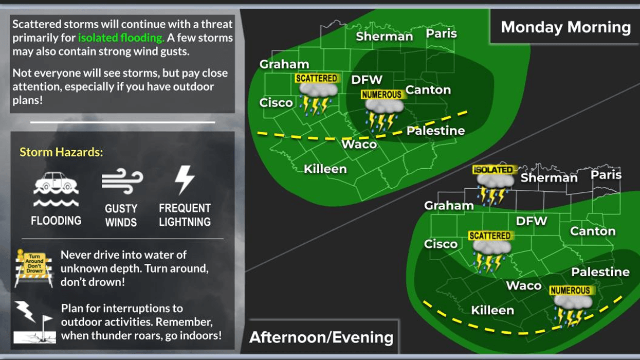

I talked about it during Sunday's morning weather discussion—the potential for flash flooding Sunday evening through the overnight hours into Monday—and here we are. This is what we're dealing with this morning.
Allow yourself some extra time getting to work. Flood Warnings remain in effect for parts of North Texas until 6:00 a.m., and they may need to be extended because heavy rain is still falling across portions of the Metroplex.
Good Monday morning! Rainy weather in the middle of July across North Texas doesn't happen very often, but that's exactly what we're seeing today.
Very heavy rain continues across southeastern Denton County, northwestern Dallas County, and Tarrant County. Radar shows a swath of heavy rain mainly along and north of Interstate 30, stretching from Greenville through the northern parts of Dallas and Fort Worth. These storms aren't moving much and are training over the same locations, leading to a continued flash flooding threat.
There are no Flood Watches in effect at this time, but a Flash Flood Warning is in effect for Tarrant County until 8:45am.
The setup is fairly straightforward. A surface trough is draped across the northern half of North Texas while a strong upper-level disturbance slowly slides from north to south. Combined with abundant Gulf moisture, it's producing periods of very heavy rainfall.
We'll continue to see waves of heavy rain today, especially along and south of Highway 380. As we head into late this afternoon and this evening, another area of rain is expected to redevelop south of the Dallas-Fort Worth Metroplex and continue through the overnight hours into Tuesday.
The flooding potential will increase south of Interstate 20 late tonight through Tuesday. While no Flood Watch has been issued yet, that could certainly change as confidence grows in additional heavy rainfall. Some locations could also see more rain into Wednesday.
If you live along and north of Highway 380, you'll still have scattered showers and thunderstorms today, but rain chances should taper off Tuesday and Wednesday.
Looking ahead, I'll also be watching another upper-level disturbance tracking from east to west along Interstate 40 later this week. Current forecast guidance keeps most of its impacts across the western half of Texas Thursday and Friday, but this latest system proved that forecast models can struggle with these slow-moving upper-level lows, so we'll keep a close eye on it.
Temperatures will depend on how much sunshine you see. Areas that manage some breaks in the clouds—most likely north of the Metroplex by midweek—could reach the lower 90s. Locations that stay cloudy and rainy may remain in the 80s, with morning lows holding in the 70s.
I hope you get some beneficial rainfall, stay safe if you're traveling this morning, and enjoy this rare stretch of July weather while it lasts. It's the only weather you've got!
7-Day Headlines:
- DFW Airport hit 97 degrees on Sunday
- Waves of heavy rain though tomorrow
- Flooding potential through Wednesday
- Heaviest north of I-20 today; south of I-20 Tuesday and Wednesday
- Isolated afternoon storms Thursday and Friday
- Hot and dry this weekend
- Download our AUDACY app! Listen to KRLD LIVE at home or at work
Almanac:
- Yest Rain: Trace; Yest High: 97; Low: 78
- Today’s Averages: High: 95; Low: 76
- Record high: 107(1980); Record low 64 (1990)
- July rain: 0.00”; Deficit: <1.07”>
- 2026 Rain: 21.25”; Snow: 2.4”; Deficit: 0.11”
- Sunrise: 6:30am; Sunset: 8:38pm
Forecast:
Monday: Mostly cloudy and warm. Scattered showers and storms. Flooding potential. High: 83-90. Wind: SE 5 mph.
Monday night: Cloudy and humid. Areas of heavy rain, mainly south of I-20. Flooding potential. Low: Mid 70s. Wind: SE 5 mph.
Tuesday: Mostly cloudy and warm. Scattered showers and storms. Flooding potential south of I-20. High: Low 90s, 70s in the rain. Wind: SE 5 mph.
Wednesday: Mostly to partly cloudy, warm and humid. Isolated showers and storms. Heaviest stays south and SW. High: Low 90s.
Thursday and Friday: Mostly to partly cloudy, warm and humid. Isolated late day showers and storms. High: Low to mid 90s.
Weekend: Partly cloudy, hot and humid. Highs: Mid to upper 90s.
LISTEN on the Audacy App
Tell your Smart Speaker to "PLAY 1080 KRLD"
Sign Up to receive our KRLD Insider Newsletter for more news
Follow us on Facebook | Twitter | Instagram | YouTube


