MORE RAIN COMING TO NORTH TEXAS — FLOODING REMAINS THE BIGGEST CONCERN
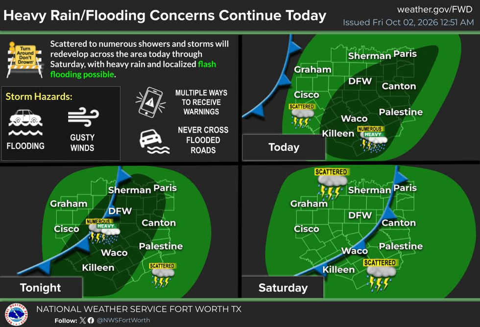
Good morning, everyone, and welcome to Friday! More rain is coming to North Texas, and as expected, the Flash Flood Watch has now been extended through 7:00 p.m. Friday morning.
We have another disturbance producing widespread rain this morning. The area of rain stretches all the way down toward Brownsville and up through the eastern Hill Country, Austin, along I-35 through Killeen and Waco, and now into parts of North Texas.
Heavy rain is currently falling across areas around Greenville, Rockwall and southeastern Dallas County, with additional rain extending south and southwest through Ellis, Johnson and Hill counties.
Rain and a few isolated thunderstorms could continue into Saturday morning and Saturday afternoon, so if you have outdoor plans or you're heading out to a high school football game tonight, make sure you have some rain gear with you. I think much of the rain should wind down by around sunset tonight, but I wouldn't completely rule out a few showers.
Saturday, if you're out running errands, keep that umbrella nearby. You may need it.
Then things begin to change by Sunday.
The upper-level disturbance currently over eastern New Mexico is expected to retrograde back toward the west. That will help set up another weak cold front late Sunday, with drier air moving into North Texas behind it.
Temperatures will drop into the upper 50s to lower 60s Monday morning through Wednesday morning, with lower humidity during the afternoons. High temperatures should climb into the lower 80s, with a return to the middle and possibly upper 80s by the end of next week.
So, after Sunday, enjoy the weather when you can. It's the only weather you've got!
7-Day Headlines:
- DFW Airport hit 81 degrees on Thursday; 3.47” of Rain
- Flood Watch until 7pm Friday
- Waves of rain today. Nothing severe
- Average rainfall totals: 1.00”; isolated 2”-3”
- One more day of rain on Saturday
- Sunshine peeks out on Sunday
- Fall-like weather next week. Humidity lowers
- Download our AUDACY app! Listen to KRLD LIVE at home or at work
Almanac:
- Yest Rain: 0.00”; Yest High: 81; Low: 69
- Today’s Averages: High: 84; Low: 63
- Record high: 99 (1951); Record low 47 (1975, 1985)
- October rain: 3.47” ”; Surplus: 3.37”
- 2026 Rain: 26.25”; Snow: 2.4”; Deficit: <1.12”>
- Sunrise: 7:24am; Sunset: 7:01pm
Forecast:
Friday: **Flood Watch ends at 7pm** Cloudy, humid and mild. Scattered showers and isolated storms. (1.00”-3.00”) High: Upper 70s. Wind: North 5-10 mph.
Friday night: Cloudy, humid and mild. Isolated overnight showers. Wind: South to north 10-20 mph.
Saturday: Cloudy and mild. Scattered showers possible. High: Upper 70s. Wind: North 5-10 mph.
Sunday: Mostly cloudy and mild. Morning drizzle and showers. Peeks of afternoon showers. High: Near 80.
Monday and Tuesday: Mostly sunny and seasonable! Drier air FINALLY arrives. High: Low 80s.
Wednesday and Thursday: Mostly sunny and nice. High: Mid 80s.
LISTEN on the Audacy App
Tell your Smart Speaker to "PLAY 1080 KRLD"
Sign Up to receive our KRLD Insider Newsletter for more news
Follow us on Facebook | Twitter | Instagram | YouTube