
Enjoy today because a strong cold front will come plowing through here tomorrow late morning, bringing wind gusts of 40 mph from the north, and sharply colder temperatures. A few lucky ones will see some showers along the front as well, but nothing even close to last Friday's event.
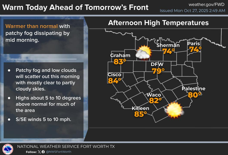
Happy Monday, my friends. I hope you had a great weekend and enjoyed the rain. Sorry for those of you that suffered damage late Friday evening. We're waking up to temperatures in the 60s under a mostly cloudy sky. At least we're not dealing with fog like we did yesterday morning. That was pretty cool, wasn't it? Clouds will break up by mid to late morning and sunshine will dominate. Afternoon highs will approach 80 degrees. Enjoy that because things are about to change.
Tonight will be relatively quiet under a partly to mostly cloudy sky. Temperatures will fall into the 60s across North Texas.
Clouds will thicken up tomorrow morning as a strong cold front approaches from the northwest. As of now, it looks like the cold front will arrive at DFW Airport shortly before noon. Temperatures will warm into the low 70s before the front arrives. Scattered showers will develop along the front, but the coverage will not be widespread and precipitation totals will be less than a tenth of an inch in most areas.
You'll know it when the front comes through. Winds will rapidly shift to the northwest and gusts to 40 mph during the afternoon and early evening. Temperatures will fall into the 50s for your evening commute home. By daybreak Wednesday, low temperatures will fall into the 40s across much of the area. Factor in the 25 mph wind gusts, wind chills will be in the 30s in most areas. Dust off your jackets.
It will be sunny, breezy, and cool for Wednesday with afternoon highs struggling to hit 60 degrees.
As the winds go calm on Thursday morning under a clear sky, temperatures will fall into the 30s away from town, low 40s at DFW. We will most likely see frost advisories issued for much of the area. Protect tender vegetation and bring your pets indoors.
Thursday looks fantastic but cool. Afternoon highs will reach the low to mid 60s under plenty of sunshine. Friday will be equally as nice with morning lows into the upper 30s to mid 40s, afternoon highs will reach the mid 60s. Trick-or-treaters will have temperatures in the low to mid 50s. Layer up. South winds will return into the weekend as temperatures warm back into the 70s.
A brief note on Hurricane Melissa: as of 5:00 a.m. Eastern Daylight Time, winds have increased to 160 mph, making this a category 5 hurricane. Landfall is expected sometime tomorrow evening in the western third of Jamaica. This will spare the eastern 2/3 of the island from catastrophic wind damage. Melissa's hurricane force wind field only extends 35 miles from the center of circulation. This is a very SMALL storm for a CAT 5. This means the western third of Jamaica will take the brunt of this hurricane from catastrophic winds. Unfortunately, if the current track is correct, Montego Bay may take a direct hit. I'll have more in separate posts throughout the next 48 hours.
Have a good day today and please enjoy the weather when you can; it's the only weather you've got.
7-Day Headlines:
DFW hit 74 degrees on Sunday.
3.10” of rain last Friday. New record. Surplus of rain has returned.
Mild today; Colder tomorrow.
Lunchtime Tuesday cold front.
Scattered showers possible.
Below average temperatures the rest of the week.
Frost possible Thursday morning.
Weekend warm up.
*Yest Rain: 0.00”; Yest High: 74 Low: 60
*Today’s Averages: High: 74; Low: 53
*Record high: 90 (1938); Record low: 29 (1957)
*October Rain: 0.24”; Surplus: 1.12”
*2025 Rain: 32.91”; Surplus: 2.01
*Sunrise: 7:43am; Sunset: 6:40pm
Monday: Morning clouds, afternoon sun. High: Near 80. Wind: SE 5-10 mph.
Monday night: Increasing clouds and mild. Low: Low to mid 60s. Wind: SSE 5-10 mph.
Tuesday: Morning clouds, late afternoon sunshine. Lunchtime cold front brings scattered showers, wind and MUCH cooler temperatures. High: Low 70s. Wind: SE to NNW 20-30, G40 mph.
Wednesday: Sunny, VERY windy and cool. Low: Mid to upper 40s; High: Near 60.Wind: NNW 20-30, G40 mph.
Thursday: Morning frost, afternoon sun. Not as windy. Cool! Low: 35-41; High: Mid 60s.
Friday: Sunny and perfect! High: Near 70.
Saturday: Passing high clouds and warmer. High: Low to mid 70s.
Sunday: Mostly sunny, wind and warm. High: Near 80.
LISTEN on the Audacy App
Tell your Smart Speaker to "PLAY 1080 KRLD"
Sign Up to receive our KRLD Insider Newsletter for more news
Follow us on Facebook | Twitter | Instagram | YouTube