



Another hot weekend? Yep. But hang in there, North Texas!
The good news is…the heat is finally losing its grip! Cooler weather will begin moving in toward the end of the week and into next weekend — and FINALLY, we have some legitimate rain chances to talk about!
We're looking at very high rain chances Wednesday evening through Friday. Now, that does NOT mean it's going to rain everywhere all the time. But the setup is becoming increasingly interesting as a strong upper-level low slowly meanders around Texas.
And folks, this could become a very serious flooding situation for parts of North Texas, Central Texas, the Hill Country, East Texas and the Texas coast.
Meanwhile, the remnants of Polo — POLO, not Marco! — will work their way across West Texas and into the Panhandle late Tuesday into Wednesday.
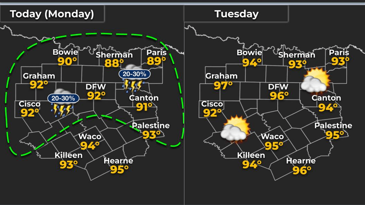
This morning, a few showers moved through Cooke and Grayson counties overnight and into parts of Collin County. Some of you actually got wet! Hallelujah! Most of North Texas, however, stayed dry.
Temperatures are starting out in the 70s and will climb into the mid-90s today and Tuesday, with plenty of humidity. Heat index values will push back toward 100 degrees, but no Heat Advisories are currently in place.
Then comes the weather change.
By late Wednesday into Thursday, the upper-level low becomes the big player. Exactly where that low stalls and eventually retrogrades will determine where the heaviest rain sets up and how long it sticks around.
The BIG question: Does the heaviest rain shift east by Friday and Saturday, or does it hang around North and Central Texas?
If it hangs around, we could be looking at multiple rounds of heavy rain — and that's when flooding becomes a much bigger concern.
Yes, we've been dealing with a severe drought, and yes, the ground can absorb a LOT of water right now. But that doesn't mean it can absorb unlimited amounts of rain in a short period of time. Heavy rain rates can still create flooding problems.
This is why I always encourage you to have multiple ways to receive weather warnings. Don't depend on just one source.
And of course, keep it tuned to NewsRadio 1080 KRLD and the KRLD Weather Center throughout the week. We'll keep you updated on the timing, rainfall amounts and any developing flood threat.
If we're under clouds and rain, temperatures could stay in the 70s, with readings only reaching the low 80s when we get a little sunshine.
Then, by late this weekend into early next week, some drier air may finally sneak in, with highs mainly in the 70s and low 80s and morning temperatures dropping into the 60s.
So yes…Summer is still hanging around for a few more days. But its bags are packed.
Meteorologist Dan Brounoff — Dan the Weatherman — and the KRLD Weather Center.
Have a great Monday, enjoy the weather when you can…because it's the only weather you've got!
7-Day Headlines:
- DFW Airport hit 96 degrees on Sunday
- A few morning showers and storms
- A hot start to the week
- Above average temperature through Wednesday
- Heavy rain threat Thursday
- Rain chances continue into the weekend
- Cooler temperatures
- Download our AUDACY app! Listen to KRLD LIVE at home or at work
Almanac:
- Yest Rain: 0.00”; Yest High: 96; Low: 76
- Today’s Averages: High: 85; Low: 74
- Record high: 105 (1953); Record low 40 (1908)
- September rain: 0.01”; Deficit: <2.47”>
- 2026 Rain: 22.62”; Snow: 2.4”; Deficit: <4.41”>
- Sunrise: 7:21am; Sunset: 7:15pm
Forecast:
Monday: Isolated morning showers and storms (north of DFW). Partly cloudy, hot and humid. Isolated late-day showers and storms. High: Low 90s. WInd: ESE 5-10 mph.
Monday night: Partly cloudy and humid. Low: Mid to upper 70s. Wind: ESE 5-10 mph.
Tuesday: Partly cloudy, hot and humid. Windy!!. High: Low 90s. Wind: SE 15-25, G30 mph.
Wednesday: Increasing clouds, breezy and humid. Showers and storms by late evening. High: Low 90s.
Thursday: Cloudy, breezy and cooler. Numerous showers and isolated storms. Heavy rain threat. High: Upper 70s.
Friday: Cloudy and mild. Showers and storms possible. High: Low 80s.
Weekend: Mostly cloudy and mild. Scattered showers and storms. Highs: Upper 70s.
LISTEN on the Audacy App
Tell your Smart Speaker to "PLAY 1080 KRLD"
Sign Up to receive our KRLD Insider Newsletter for more news
Follow us on Facebook | Twitter | Instagram | YouTube


