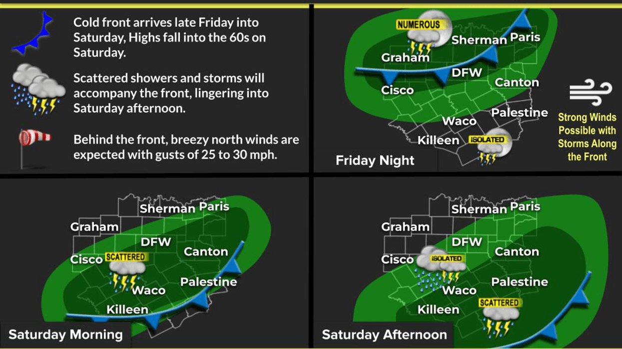
A significant weather change is expected to arrive in North Texas late tonight, bringing much cooler temperatures for the weekend and a decent chance of rain overnight through tomorrow afternoon. The below-average temperatures will persist into early next week as well.
Good morning and happy Friday. We are waking up to a low cloud bank moving in from the south once again. Temperatures are currently near 70 degrees, which is 15 degrees above the average for this time of year. There is no rain on the radar, so a dry commute to work is expected this morning. We will get some breaks in the clouds today, allowing temperatures to warm into the low to mid-80s. It will be very windy, with south winds gusting up to 30 mph. It is recommended to take allergy medication.
As mentioned earlier, a significant weather change will arrive after midnight tonight as a strong cold front moves through the area while you are sleeping. The front will pass from north to south between 3:00 a.m. and 7:00 a.m. Temperatures will drop from the low 70s to near 50 degrees by 8:00 a.m. There will also be a large area of showers and non-severe thunderstorms moving through the area during this time frame, with the heaviest rain expected to fall during this period. On and off shower activity will continue through late morning, ending from northwest to southeast during the afternoon on Saturday. Temperatures will hover in the 50s for most of the day but may rise to the low 60s if sunshine is visible, especially along and north of Highway 380. The 30 mph wind will make it a chilly and blustery day.
The skies will clear overnight on Saturday, leading to a beautiful Sunday. Morning lows will dip into the 40s, with afternoon highs reaching close to 70 degrees. Enjoy!

Clouds will be in and out from Monday to Wednesday of next week as a disturbance slowly moves across South Texas. While a few showers cannot be ruled out during this period, measurable rain is expected to stay across Central and Southeast Texas. Afternoon highs will be in the low 70s on Monday and Tuesday, rising to near 80 degrees on Wednesday and Thursday as sunshine becomes more noticeable.
Another weather change is expected by the end of next week, bringing a chance of rain and cooler temperatures leading into the following weekend.
Have a terrific day today, a splendid weekend, and enjoy the rain and the weather when you can, it's the only weather you've got.
7-Day Headlines:
- DFW Airport reached 86 on Thursday.
- Warm and dry on Friday.
- Saturday morning's cold front brings welcome rain and colder temperatures.
- Jackets necessary this weekend.
- 40’s Sunday morning!
- A few showers return Monday into early Tuesday.
- Warming Wednesday and Thursday.
- Download our AUDACY app. Listen to KRLD at home!
Almanac:
- Yest Rain: 0.00”; Yest High: 86; Low: 68
- Today’s Averages: High: 76; Low: 55
- Record high: 101 (2006); Record low 35 (1921)
- April rain: 2.71”; Surplus: 1.14”
- 2026 Rain: 7.87”; Snow: 2.4” Deficit: <2.29”>
- Sunrise: 6:55am; Sunset: 8:01pm
Forecast:
Friday: Morning clouds, becoming partly cloudy by afternoon. Warm and windy. High: Low to mid 80s. Wind: SE 15-25, G30 mph.
Friday night: Increasing clouds, turning windy and colder. Showers and non-severe storms after 3am. Low: Low 70s. Wind: South to north 15-25, G30 mph.
Saturday: Cloudy, windy and rainy through early afternoon. TOTALS: 0.50-1.00”. Temperatures steady in the 50s. 60’s north of HWY 380. Wind chills in the 40’s. Wind: North 15-25, G30 mph.
Sunday: PERFECT! Sunny and cool. Low: 43-48; High: Near 70.
Monday: Increasing clouds and cool. Slight chance of showers. High: Mid to upper 60s.
Tuesday: Mostly cloudy and pleasant. Morning showers. High: Low 70s.
Wednesday: Mostly to partly cloudy and nice! High:Near 80.
Thursday: Partly cloudy, warm and breezy. High: Near 80.
LISTEN on the Audacy App
Tell your Smart Speaker to "PLAY 1080 KRLD"
Sign Up to receive our KRLD Insider Newsletter for more news
Follow us on Facebook | Twitter | Instagram | YouTube