Well, another weekend has flown by! I hope you had a great one. It was certainly a hot weekend, with temperatures climbing well into the mid-90s, and we'll keep that summer heat around for today and tomorrow. After that, cooler weather and increasing rain chances return to the forecast as we head into the middle and latter part of the week.
Good morning, everyone!
It's a very balmy start to the day across North Texas, with temperatures in the mid to upper 70s under partly cloudy skies. Highs this afternoon will once again reach the mid-90s, with heat index values approaching 100 degrees. An Air Quality Alert is also in effect today across North Texas.
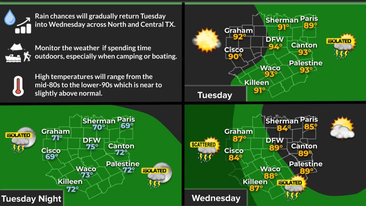
Tomorrow, a cold front will back in from the northeast. Showers and thunderstorms are expected to develop during the peak heating hours Tuesday afternoon and evening.
By Wednesday, the front will settle a little farther south and west of the area, limiting widespread rainfall, but scattered late-day showers and storms will still be possible. The better rain chances on Wednesday will be west of Highway 281 and into the Big Country.
As we head into Thursday and Friday, the front will begin lifting back to the northeast while a couple of upper-level disturbances move in from the southwest. This setup will bring scattered showers and thunderstorms, primarily during the afternoon and evening hours, with coverage increasing compared to earlier in the week. Those rain chances are expected to continue into Saturday before gradually tapering off by Sunday.
Temperatures after today and tomorrow will be noticeably cooler, with highs mainly in the mid-80s thanks to increased cloud cover and rainfall.
If you encounter one of this week's stronger storms, brief heavy rainfall, small hail, gusty wind and frequent lightning will be possible. I'm not overly concerned about flooding at this time, but it's something we'll continue to monitor as the week progresses.
Hope you get some beneficial rain!
Have a great day today and enjoy the weather when you can, it's the only weather you've got!
7-Day Headlines:
- DFW Airport hit 95 degrees on Sunday.
- Hot and humid today and Tuesday
- Heat index values near 100 degrees
- Scattered showers and storms return Tuesday through Saturday
- Threats: Heavy rain, lightning, gusty wind, small hail
- Not everyone will see rain
- Slightly cooler
- Download our AUDACY app. Listen to KRLD at home
Almanac:
- Yest Rain: 0.00”; Yest High: 95; Low: 75
- Today’s Averages: High: 89; Low:69
- Record high: 102 (1911); Record low 48 (1903)
- May rain: 2.96”; Deficit: <01.82”>
- 2026 Rain: 13.18”; Snow: 2.4” Deficit: <3.14”>
- Sunrise: 6:20am; Sunset: 8:32pm
Forecast:
Monday: *Air Quality Alert* Partly cloudy, warm and humid. High: Mid 90s. Heat index: Upper 90s. Wind: SE 5-10 mph.
Monday night: Partly cloudy and humid. Low: Mid 70s. Wind: SW 5-10 mph.
Tuesday: Increasing clouds, hot and humid. Late day showers and storms return along a backdoor cold front. High: Low to mid 90s. Wind: NE 5-10 mph.
Wednesday: Partly cloudy and a bit cooler. Isolated late day storms. Greatest chance west of DFW. High: Mid 80s.
Thursday - Saturday: Partly cloudy, warm and humid. Scattered afternoon and evening showers and storms. Highs: 88-92.
Sunday: Partly cloudy, warm and humid. An isolated late day storm. High: Low 90s.
LISTEN on the Audacy App
Tell your Smart Speaker to "PLAY 1080 KRLD"
Sign Up to receive our KRLD Insider Newsletter for more news
Follow us on Facebook | Twitter | Instagram | YouTube