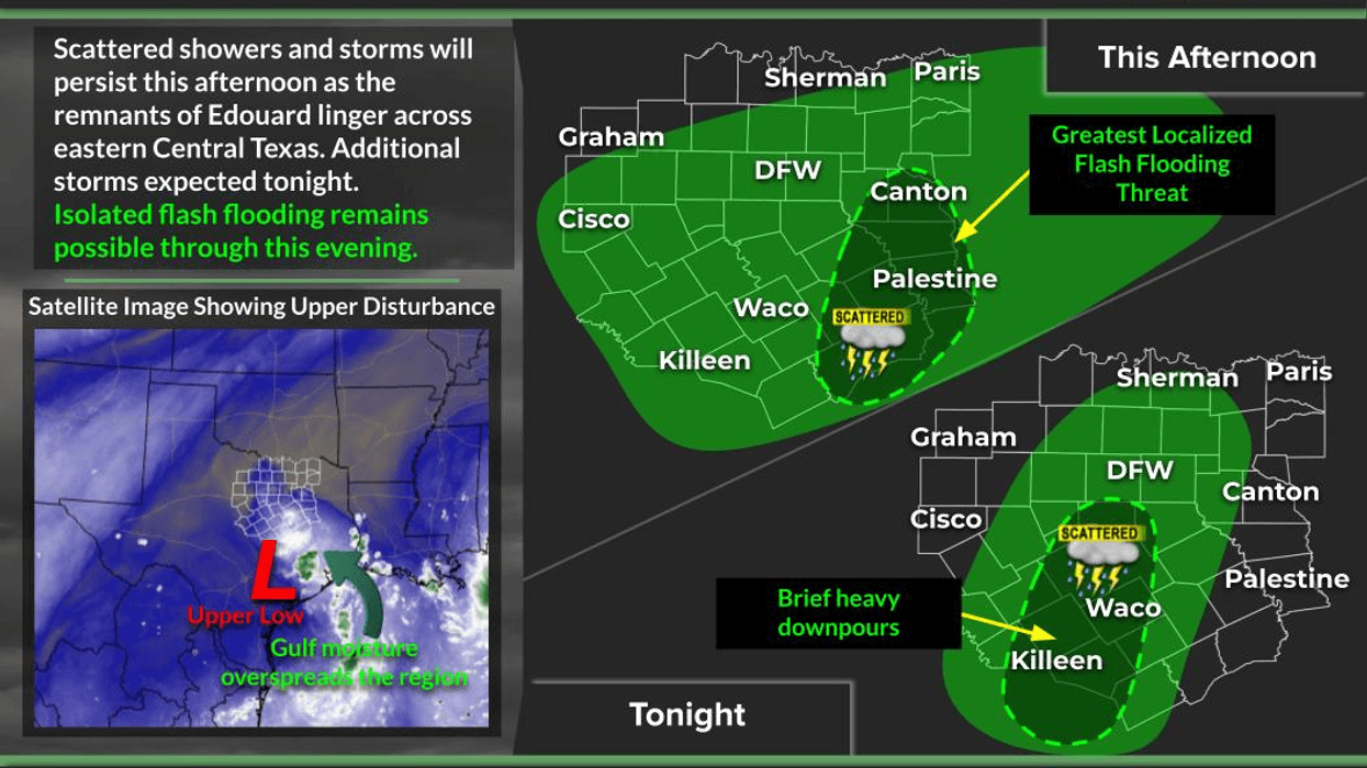

A lot of North Texas missed out on the rain from the remnants of Edouard, but during the morning hours, we do have a few scattered showers across parts of Parker and Tarrant counties. The good news is that these showers are drifting west.
Unfortunately, there is a lot more rain south of Interstate 20 right now, pretty much paralleling Highway 281. From around Lipan, down toward Tolar, Stephenville and the Hamilton area, you're seeing some of the heavier activity. This is the remnants of Edouard, but unfortunately, it's moving west instead of northeast, so it won't bring widespread rain to all of North Texas.
Looking ahead to tomorrow and all the way through the holiday weekend, we'll be dealing with an area of high pressure that's strongest to our north across Kansas, Arkansas, Missouri and Oklahoma. Heat Advisories are in effect today, with Extreme Heat Warnings across parts of the Midwest. That's where the hottest weather will be through the holiday weekend.
Here in North Texas, we'll be on the southern fringe of that upper-level high, which will tend to deflect any rain coming in from the east over the weekend. Another system will be paralleling Interstate 10 from Alabama and Mississippi into Louisiana, but unfortunately, most of that activity will stay across the southern half of the state.
So, if you have beach plans along the Texas coast, I'm terribly sorry. There will be plenty of scattered showers and thunderstorms around. Most of those storms should dissipate after sunset, but if you hear thunder, seek shelter immediately. There could also be some rough seas and gusty winds along the coast.
Otherwise, here in North Texas, we'll reach the upper 90s today, with similar temperatures on Saturday. We'll be pushing 100 degrees again Sunday and Monday as our consecutive rain-free streak continues.
We're now at 50 consecutive days without measurable rain at DFW Airport, and we're still stuck at 39 triple-digit days. We'll probably add a few more to that total, if not by Sunday or Monday, then certainly at some point next week.
Fall officially begins in 18 days. It's certainly not going to feel like fall anytime soon, but we typically see at least one decent cold front before the end of September. So that's something to look forward to.
Have a great weekend, ladies and gentlemen. Thanks so much for following my page, and enjoy the weather when you can. That's the only weather you've got!
7-Day Headlines:
- DFW Airport ONLY hit 94 degrees on Thursday
- 39 triples this summer
- 50 days with no measurable rain at DFW
- Edouard diving SW away from north Texas!
- Isolated late-day showers today
- Heating up back up Labor Day weekend
- Staying unseasonably hot through next week
- Download our AUDACY app! Listen to KRLD LIVE at home or at work
Almanac:
- Yest Rain: 0.00”; Yest High: 94; Low: 76
- Today’s Averages: High: 92; Low: 72
- Record high: 111 (2000); Record low 55 (1974)
- September rain: 0.00”; Deficit: <0.29”>
- 2026 Rain: 22.61”; Snow: 2.4”; Deficit: <2.23”>
- Sunrise: 7:05am; Sunset: 7:48pm
Forecast:
Friday: Partly cloudy, hot and humid. Isolated showers and storms.High: Upper 90s. Wind: SE 10-15 mph.
Friday night: Mostly clear, mild and humid. Low: Mid to upper 70s. Wind: SE 5-10 mph.
Saturday and Sunday: Partly cloudy and hot. High: Upper 90s. Wind: South 5-10 mph.
Labor Day: Mostly sunny and hot. High: Near 100.
Tuesday - Thursday: Mostly sunny, continued hot. High: Near 100.
LISTEN on the Audacy App
Tell your Smart Speaker to "PLAY 1080 KRLD"
Sign Up to receive our KRLD Insider Newsletter for more news
Follow us on Facebook | Twitter | Instagram | YouTube