Cooler than average temperatures, no rain, near record low for Wednesday with a killing frost, and then a rapid warm-up towards the weekend. Those are your weather highlights as we work our way into our new work week.
We're waking up to temperatures near 60° with plenty of cloud cover overhead. Unfortunately, all the rain today will fall well to the south of DFW. I'm expecting slow clearing and cool temperatures today. Afternoon highs will reach the upper 60s with the north wind at 10 to 20 mph.
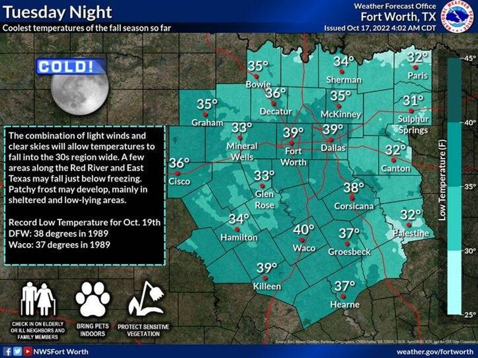
Skies will clear by the evening through the overnight, with morning low temperatures in the upper 30s to upper 40s. The wind will keep temperatures from falling into the 30s area-wide.
A reinforcing shot of cooler/drier air arrives late tonight. Plenty of sunshine will dominate tomorrow with afternoon highs ONLY in the low 60s. The wind will continue from the north at 10 to 20 mph.
 National Weather Service - Fort Worth
High pressure at the surface will settle overhead Wednesday morning. This being said, with clear skies and virtually calm wind, near record low temperatures are expected. The record for Wednesday morning is 38°. I'm forecasting a low of 41 degrees in the immediate Dallas/Fort Worth area, but there will be widespread thirties surrounding the Metroplex. I'm expecting a frost advisory to be issued tomorrow for Wednesday morning. Make sure you protect your plants and tender vegetation before you go to bed Tuesday night. This will be the 7th coldest air mass for October 17th since records have been kept.
 National Weather Service - Fort Worth
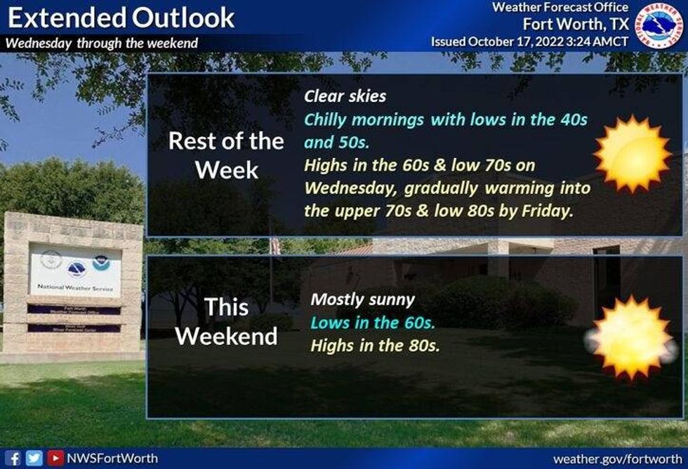
Skies will be clear on Wednesday with afternoon highs in the upper 60s. Mid to upper 70s for Thursday and then we warm up rapidly Friday through the weekend. Temperatures will warm into the 80s. It will also be very windy this weekend with a high grass fire danger.
*Yest Rain: 0.07"; High: 80; Low: 64
*Today's Averages: High: 78; Low: 57
*Record high: 95 (1972); Record low: 41 (1976)
*October rain: 0.07"; October deficit: 1.93"
*2022 Rain: 23.49"; 2022 deficit: 5.78"
*Sunrise: 7:34am; Sunset: 6:53pm
Today: A slow decrease in clouds, and cool. High: Upper 60s. Wind: NNE 10-20 mph.
Tonight: Clear and chilly. Low: 39-47. Wind: North 10-20 mph.
Tuesday: Sunny, breezy and cooler. Another cold front. High: Low 60s. Wind: North 10-20 mph.
Tuesday night: Clear, cold and calm. A killing frost is possible. Low: Mid to upper 30s! * Record is 38 degrees.*
Wednesday: Sunny and cool. High: Mid 60s.
Thursday: Sunny and warmer. High: Mid to upper 70s.
Friday: Sunny and warm. High: Low 80s.
Weekend: Sunny, windy and warm. Highs: Mid to upper 80s.

LISTEN on the Audacy App
Tell your Smart Speaker to "PLAY 1080 KRLD"
Sign Up and Follow NewsRadio 1080 KRLD