High pressure remains in control, but we're on the western edge of that upper-level ridge that's been dominating the eastern third of the country. That ridge will stay in place through the holiday weekend, giving us an east-to-west flow aloft that'll send a few disturbances across North Texas beginning tomorrow and continuing off and on into early next week.
Good morning, everyone, and welcome to Wednesday! Temperatures are starting out in the upper 70s, and that's where they'll be each morning through the holiday weekend. Afternoon highs climbed into the upper 90s yesterday, and you can expect more of the same through Saturday. By Sunday and Monday, we'll shave a couple of degrees off those highs thanks to increasing cloud cover.
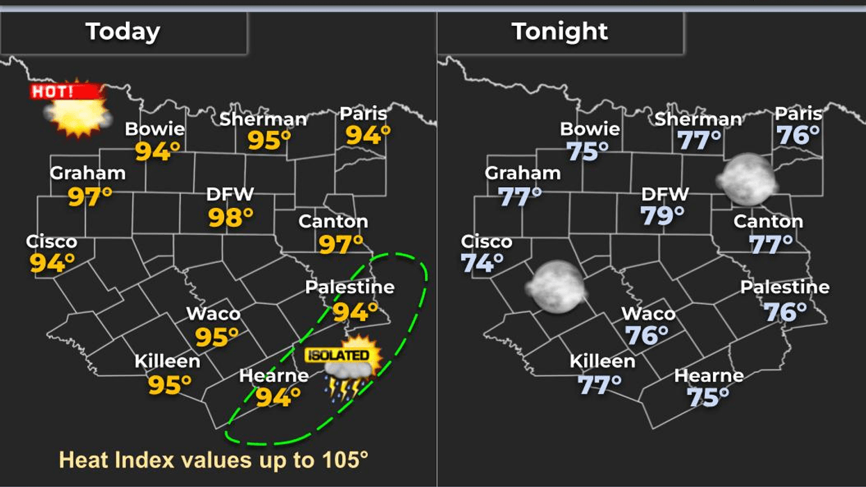
No rain is expected today. Tomorrow, a few isolated storms will develop mainly east of Canton and Greenville, with a chance they drift a little closer to McKinney and Dallas. The same setup looks likely on the Fourth of July, with scattered afternoon and evening storms developing after about 4:00 or 5:00 p.m.
If you hear thunder, get out of the water and head indoors. Right now, I think most fireworks shows Friday and Saturday will be able to go on, but keep an eye on the radar and have a backup plan just in case.
By Sunday and Monday, another disturbance will increase rain chances to around 40 percent. The main threats will be frequent lightning, heavy downpours, and gusty winds. Remember: if thunder roars, go indoors.
And with the heat sticking around, be sure to stay hydrated, take breaks if you're outside, and always check your back seat for children and pets. Highs will remain in the mid to upper 90s through the holiday weekend, with heat index values running a few degrees higher.
After Monday, the upper-level ridge builds back overhead, rain chances fade away, and temperatures climb back into the upper 90s, with a few spots nearing 100 degrees.
Stay cool, stay hydrated, and enjoy the weather when you can—it's the only weather you've got!
7-Day Headlines:
- DFW Airport hit 95 degrees on Wednesday
- Saharan dust through Thursday
- Wind relaxes Thursday
- Upper 90s through the holiday weekend
- Isolated late day storms EAST of DFW through Saturday
- Scattered afternoon and evening showers and storms Sunday and Monday
- Mosquitoes for all to enjoy. DEET for 600 Alex
- Download our AUDACY app. Listen to KRLD at home or at work
Almanac:
- Yest Rain: 0.00”; Yest High: 95; Low: 78
- Today’s Averages: High: 94; Low: 74
- Record high: 109 (1980); Record low 64 (1924)
- June rain: 8.07”; Surplus: 4.37”
- 2026 Rain: 21.25”; Snow: 2.4”; Surplus: 0.96”
- Sunrise: 6:24am; Sunset: 8:40pm
Forecast:
Wednesday: Mostly sunny, hot and breezy. Isolated late day showers and storms EAST of DFW. High: Mid to upper 90s. Heat index: Near 102 degrees. Wind: SE 10-20 mph.
Wednesday night: Partly cloudy, breezy and mild. Low: Upper 70s. Wind: South 10-20 mph.
Thursday: Mostly sunny, hot and breezy. Isolated late day showers and storms EAST of DFW. High: Mid to upper 90s. Heat index: Near 102 degrees.
Friday: Partly cloudy and breezy. Scattered late day showers and storms Dallas -> EAST. Highs: Upper 90s. Heat index: Near 102.
Independence Day: Partly cloudy and hot. 30% chance of afternoon and early evening showers and storms, mainly east of DFW. High: Upper 90s.
Sunday: Partly cloudy and hot. 30% chance of afternoon and early evening showers and storms. High: Mid to upper 90s.
Monday: Partly cloudy and hot. 30% chance of afternoon and early evening showers and storms. High: Mid to upper 90s.
LISTEN on the Audacy App
Tell your Smart Speaker to "PLAY 1080 KRLD"
Sign Up to receive our KRLD Insider Newsletter for more news
Follow us on Facebook | Twitter | Instagram | YouTube