



We made it through another work week! Over the past four days, we've hit 101° at DFW Airport every single day. I believe we're up to 14 triple-digit days this summer—who's counting? HA! The average since 1991 is about 20 days, so at this pace we'll likely reach that by the middle of next week.
Good morning, everyone, and welcome to Friday!
It's another balmy morning with temperatures in the upper 70s to lower 80s. There's no rain on radar, so you'll have a dry commute to work. However, by this time tomorrow morning, the weather could be a different story.
Let's get to today's forecast first.
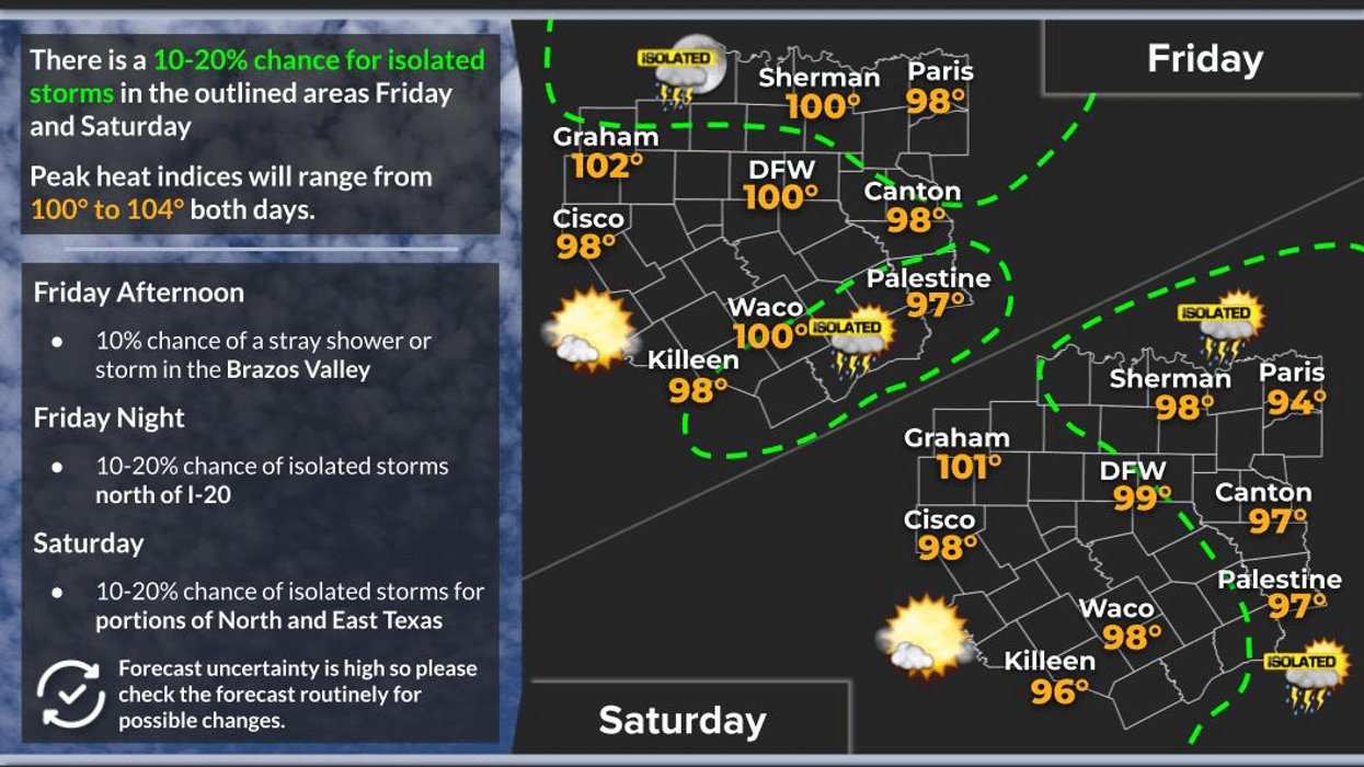
We're still on the eastern edge of a strong upper-level high centered over the Desert Southwest, but a northerly flow pattern is setting up across North Texas. That should allow temperatures to climb to around 100 to 101 degrees this afternoon with a south wind at 5 to 10 mph.
Overnight tonight, a complex of thunderstorms is expected to move into our eastern counties—from Sherman to McKinney, Dallas, Waxahachie, and points east. So don't be surprised if you hear a rumble of thunder early Saturday morning.
Those storms should gradually weaken through the morning, but if any outflow boundaries remain, combined with afternoon temperatures approaching 100 degrees again, we could see a few widely scattered showers and thunderstorms develop Saturday afternoon across the eastern half of North Texas. Areas west of I-35W should stay mainly dry.
Sunday looks very similar, with highs once again around 100 degrees.
Next week, high pressure rebuilds over the region. Look for highs near 100 Monday, 101 Tuesday, and 102 Wednesday and Thursday.
The average high for this time of year is still 97 degrees, but after August 15 we'll finally begin that gradual seasonal slide toward cooler weather.
Hopefully, some of you will see a little rain tomorrow morning.
Have a great weekend, and enjoy the weather while you can—it's the only weather you've got!
7-Day Headlines:
- DFW Airport hit 101 degrees on Thursday
- 14 triples this summer
- 23 days with no rain at DFW
- No Heat Advisories….for now
- Scattered showers and storms Saturday morning
- Triple digits through next week
- Download our AUDACY app! Listen to KRLD LIVE at home or at work
Almanac:
- Yest Rain: 0.00”; Yest High: 101; Low: 81
- Today’s Averages: High: 97; Low: 77
- Record high: 106 (1951, 1953, 1988); Record low 651 (1997)
- August rain: 0.00”; Deficit: <0.35”>
- 2026 Rain: 22.61”; Snow: 2.4”; Deficit: <0.11”>
- Sunrise: 6:47am; Sunset: 8:20pm
Forecast:
Friday: Partly cloudy and hot. High:101. Heat index: 102. Wind: South 5-10 mph.
Friday night: Increasing clouds and warm. Isolated early morning showers and storms (eastern half of north Texas). Low: Upper 70s. Wind: South 5-10 mph.
Saturday: Scattered morning showers and storms (eastern half of north Texas), becoming partly cloudy by afternoon. Isolated late-day showers and storms. High: Upper 90s. Heat index: 103.
Sunday: Partly cloudy and hot. High: near 100. Heat index 103
Monday: Mostly sunny and hot. High: 101.
Tuesday - Thursday: More of the same. Sunny and hot. High: 102
**Perseid Meteor Showers late Wednesday and Thursday**
LISTEN on the Audacy App
Tell your Smart Speaker to "PLAY 1080 KRLD"
Sign Up to receive our KRLD Insider Newsletter for more news
Follow us on Facebook | Twitter | Instagram | YouTube


