Storm chances ramp up Sunday and then again next Tuesday and Wednesday. Those three days offer the highest chance for severe weather across North Texas. Please have multiple ways to receive warnings. Temperatures will be above average over the next 7 days with a lot of wind around.
Good morning my friends and happy Friday! We made it through another week together with no severe weather. That's always nice in April. I stated about, we do have a couple of decent chances for strong to severe storms Sunday and then again next Wednesday. Reset chances on the other days over the next seven will be isolated and mainly to the west of us. We'll have a pretty strong cap in place. No trigger to initiate thunderstorms.
We're waking up to temperatures in the 60s at this hour with a mostly cloudy sky. Partly cloudy, warm, and breezy today with highs reaching the low 80s. There is a small chance of some showers sneaking in from the south before the day is done, but most of the rain will stay a good 60 to 80 Mi south of us, and then we'll be widely scattered as well.
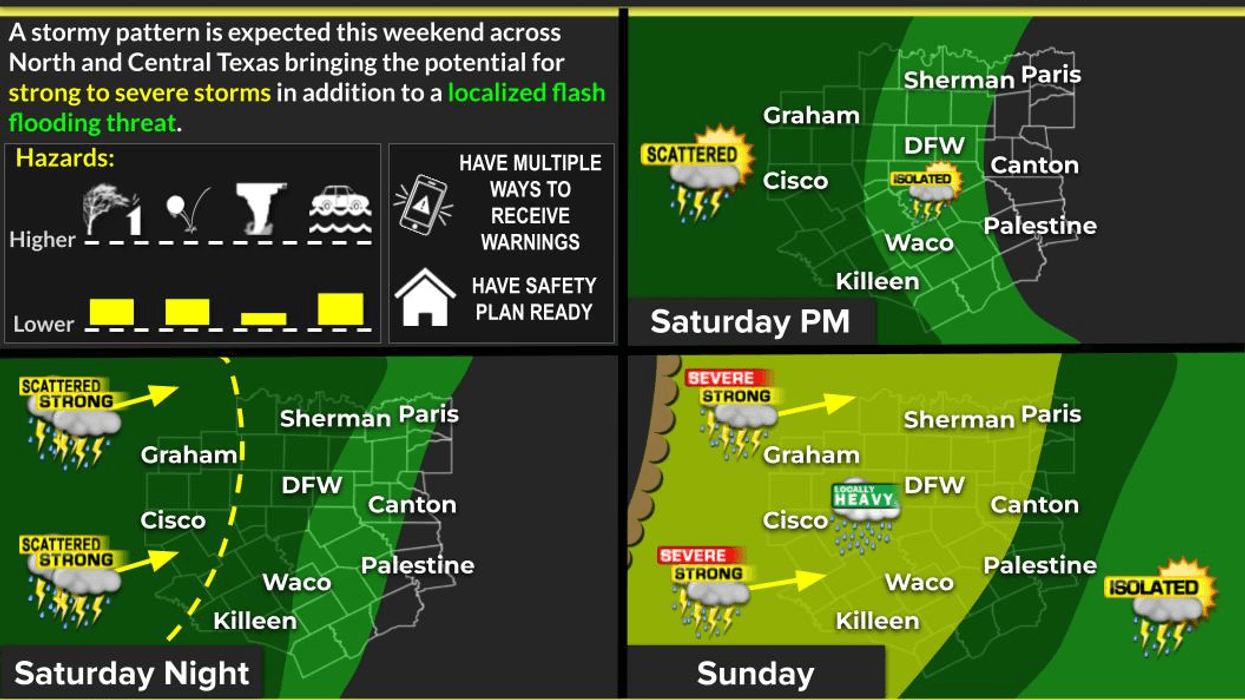
I'm not concerned about rain on Saturday but it will be mild and breezy with highs in the low 80s. By Saturday night, a large area of showers and storms will form out in West Texas and the Panhandle. These individual cells will form a line of storms and come through the area towards daybreak Sunday morning. There could still be a few strong storms but they should weaken as they move across Interstate 35W.
By late afternoon Sunday, leftover boundaries will produce more showers and storms, some of them may become severe late Sunday in the early Monday morning. I'll keep an eye on things for you but I'm not overly concerned about a big tornado threat. Mainly gusty winds and small hail. Sunday's high will be near 80°.
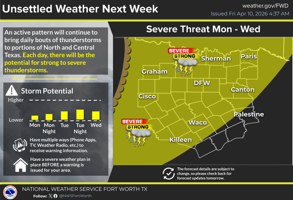
A strong cap will be in place next Monday and most of Tuesday but storms will fire to the west of us. These will be hard pressed to move into our area. Afternoon highs will warm to near 80.
A stronger disturbance moves in from the west Wednesday producing a decent shot of showers and storms to the west of the Dallas-Fort Worth area by Wednesday afternoon. These storms will progress eastward through the evening and overnight. Isolated severe possible. Afternoon highs reach the low 80s.
Right now Thursday looks mainly dry with afternoon highs in the low to mid 80s under a partly cloudy sky. After that, a cold front will flirt with the area on Friday and Saturday of next week producing more storm activity and slightly cooler temperatures. That forecast is subject to change, because now we're looking at day eight and nine. Stay tuned!
I will monitor the weather on Sunday morning and will jump on NewsRadio 1080am KRLD if necessary on Sunday.
Have a great day today and a terrific weekend. Enjoy the weather when you can, it's the only weather you've got!
7-Day Headlines:
- DFW Airport reached 81 on Thursday.
- Highs near 80 degrees through the middle of next week.
- A few showers south of DFW on Friday.
- Storm chances increase late on Sunday. Some severe.
- Stormy pattern returns Tuesday and Wednesday. Some severe.
- Download our AUDACY app. Listen to KRLD at home!.
Almanac:
- Yest Rain: 0.00”; Yest High: 81; Low: 62
- Today’s Averages: High: 75; Low: 54
- Record high: 98 (1963); Record low 30 (1973)
- April rain: 2.59”; Surplus: 1.71”
- 2026 Rain: 7.75”; Snow: 2.4” Deficit: <1.72”>
- Sunrise: 7:03am; Sunset: 7:56pm
Forecast:
- Friday: Partly cloudy, breezy and warm. A few showers and storms late in the day, mainly south of DFW. High: Low 80s. Wind: South 5-10 mph.
- Friday night: Increasing clouds and mild. Low: Mid 60s. Wind: South 5-10 mph.
- Saturday: Mostly to partly cloudy, breezy and warm. Scattered showers and storms after midnight. Some severe (mainly west of DFW). Threats: Wind and hail. High: Near 80.
- Sunday: AM showers and strong storms, becoming partly cloudy, breezy and warm. Late afternoon and evening strong to severe thunderstorms (Mainly south and east of DFW). High: Near 80.
- Monday: Morning clouds, afternoon sun. Isolated late day storms, mainly west of DFW. High: Low 80s.
- Tuesday and Wednesday: Partly cloudy, breezy and warm. Scattered showers and storms. Some severe. High: Near 80.
- Thursday: Partly cloudy, warm, and breezy. High: Low 80s.