
We're high and dry across North Texas, and that pattern will continue through at least Saturday. But, by Sunday, showers and storms return to North Texas.
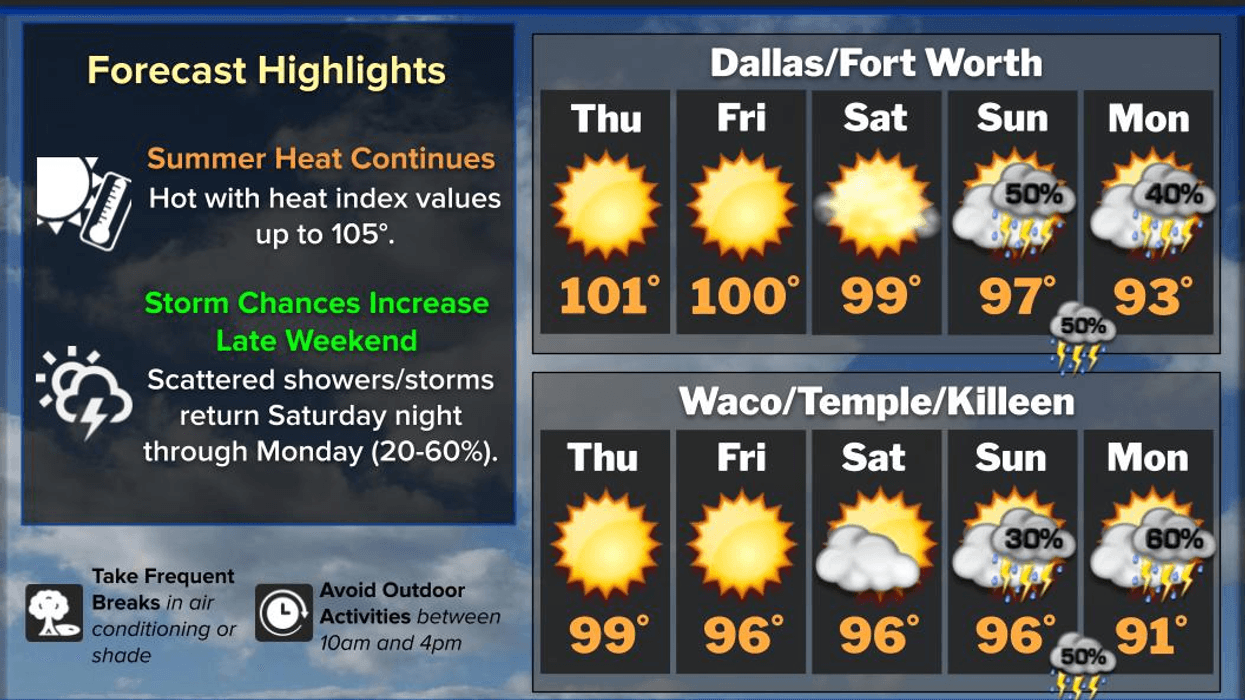
So far this summer, we've had two triple-digit days at DFW Airport. We reached 101° on Wednesday and 100° on Tuesday, and we'll likely do it again today and probably tomorrow as a strong bubble of high pressure continues to dominate our weather.
We'll see some fair-weather cumulus clouds bubble up during the afternoon today and tomorrow, but I don't expect any rain across North Texas.
If you live or plan to travel south of a line from Waco to Palestine tomorrow, keep an eye on the sky after about 6 or 7 p.m. A seabreeze boundary may drift that far north and spark a few isolated showers and thunderstorms. Any storms that develop will weaken quickly after sunset. A similar setup is expected on Saturday, with a few storms also trying to sneak in from the northwest into North Texas.
High temperatures on Saturday should stay in the upper 90s. After that, our weather pattern begins to change. The upper-level ridge of high pressure is expected to split, with one part shifting west and the other east. That creates a weakness in the atmosphere and allows more southeasterly to easterly flow aloft.
That change will send a disturbance into North Texas Sunday and Monday. Combined with a stalling boundary sliding in from the north, daytime heat and plenty of moisture, we'll see scattered showers and thunderstorms develop. Rain chances increase to around 60% Sunday and 40% Monday. The good news is that some communities will finally pick up some beneficial rainfall, although others may still miss out.
The added clouds and rain will also knock temperatures back near 90 on Sunday and into the low 90s on Monday. By Tuesday, only a few renegade showers or storms should remain, mainly south of the DFW Metroplex.
By the middle to latter part of next week, high pressure rebuilds across Texas. Temperatures will begin climbing again, but right now I don't see any additional triple-digit heat after tomorrow—perhaps Saturday comes close, but then we should get a break for a while.
I hope everyone has a great day! Enjoy the weather when you can—it's the only weather you've got!
7-Day Headlines:
- DFW Airport hit 101 degrees on Wednesday
- Triple digits likely today and Friday
- Heat index near 105
- Storms flirt with us late Saturday
- Scattered storms return Sunday and Monday
- Cooler Sunday through Wednesday
- Download our AUDACY app! Listen to KRLD LIVE at home or at work
Almanac:
- Yest Rain: 0.00”; Yest High: 101; Low: 79
- Today’s Averages: High: 95; Low: 75
- Record high: 106 (1996); Record low 64 (1968, 1972)
- July rain: 0.00”; Deficit: <0.78”>
- 2026 Rain: 21.25”; Snow: 2.4”; Surplus: 0.18”
- Sunrise: 6:28am; Sunset: 8:39pm
Forecast:
Thursday: Mostly sunny, breezy and hot. High: 97-101. Heat index: Near 105 degrees. Wind: SSW 10-20 mph.
Thursday night: Clear, breezy and muggy. Low: Near 80. Wind: South 10-20 mph.
Friday: Mostly sunny, breezy and hot.High: near 100. Heat index: Near 105 degrees. Wind: SSW 10-20 mph.
Saturday: Partly cloudy, a few degrees cooler. Slight storm chance by evening. High: Upper 90s. Heat index near 103.
Sunday. Mostly cloudy and cooler. Scattered showers and strong storms. High: Upper 80s.
Monday: Partly cloudy and humid. Scattered late day showers and storms. Highest coverage south of I-20. High: Low 90s.
Tuesday: Partly cloudy and hot. An isolated late-day storm. High: Mid 90s.
Wednesday: Partly cloudy and hot. High: Mid 90s.
LISTEN on the Audacy App
Tell your Smart Speaker to "PLAY 1080 KRLD"
Sign Up to receive our KRLD Insider Newsletter for more news
Follow us on Facebook | Twitter | Instagram | YouTube