
GOOD MORNING, NORTH TEXAS! HAPPY MONDAY!
Welcome to Monday, everyone! It’s Columbus Day, and some of you may have the day off today. Banks are closed, and there will be no regular mail delivery.
We have a few more VERY warm days ahead, along with breezy conditions, before a strong cold front brings a much-needed change to North Texas just in time for the weekend!
And folks, don’t forget — THIS IS THE LAST WEEKEND OF THE STATE FAIR OF TEXAS! If you’ve been waiting for cooler weather to head out to Fair Park, this may be your weekend!
**NORTH TEXAS FORECAST: SUMMER ISN’T DONE JUST YET!**
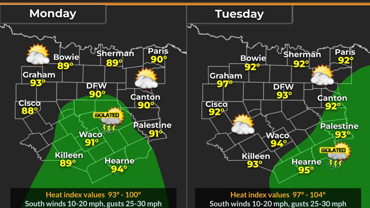
It’s a muggy start to our Monday, and those southerly winds will continue pumping Gulf moisture into North Texas. Expect breezy conditions today, tomorrow, and Wednesday, with wind gusts potentially reaching 25 mph.
**TODAY (MONDAY):**
- Highs in the low 90s.
- Breezy with increasing humidity.
- A generally enjoyable day, but definitely warm!
**TUESDAY:**
- Highs potentially reaching the middle 90s!
- Low clouds begin creeping in from the south.
- Scattered showers are possible, especially during the afternoon.
**WEDNESDAY:**
- Highs in the low 90s.
- Continued breezy and humid.
- A few additional showers may develop, particularly across eastern parts of our area.
**WHERE COULD IT RAIN?**
Our best chances for scattered showers Tuesday will generally be along and east of a line from Sherman to McKinney to Dallas to Waxahachie, with better coverage possible farther east into East Texas.
A few showers could linger into Wednesday, but widespread rainfall is not expected at this time.
**THE BIG WEATHER STORY: A STRONG COLD FRONT!**
A strong cold front is expected to push into North Texas late Thursday, potentially bringing a welcome end to our stretch of 90-degree temperatures!
Could we see showers and thunderstorms with the front? Possibly! However, it’s still too early to determine exactly where rain will develop or how much of North Texas will receive it.
The timing of the front and the amount of atmospheric energy available will determine whether we see anything more than a wind shift and cooler air. For now, much of the forecast remains relatively dry, but I’ll be watching developments closely through the middle of the week.
**WHAT ABOUT NEXT WEEK?**
Another upper-level low-pressure system may develop over the Desert Southwest this weekend. That system could become our next weather maker next week, depending on how it evolves and whether disturbances move close enough to North Texas. We’ll keep an eye on it!
**THE GOOD NEWS? FALL-LIKE WEATHER IS FINALLY ON THE WAY!**
Once that cold front moves through, we should see temperatures drop out of the 90s, with cooler mornings and more comfortable afternoons arriving just in time for the final weekend of the State Fair of Texas!
Here’s a look at what we can expect:
**FRIDAY:** Highs only in the low 70s, with north winds gusting to 25 mph.
**SATURDAY:** Afternoon highs in the mid-60s, with morning temperatures dropping into the 50s. It will feel much more like fall!
**SUNDAY:** Another beautiful day, with a chilly morning. Temperatures will fall into the 40s and 50s early, followed by afternoon highs near 70 degrees.
It’s going to feel much more like fall across North Texas!
I’ll continue monitoring rain chances from late Thursday into Friday morning and keep you updated as the forecast comes into better focus.
Until then, enjoy your Monday, get outside when you can, and make the most of this weather — it’s the only weather you’ve got!
PLEASE LIKE, SHARE, AND FOLLOW MY PAGE if you haven’t already! Help me keep your friends and family informed and WEATHER AWARE!
Thanks, everybody, and have a GREAT Monday!
7-Day Headlines:
- DFW Airport hit 91 degrees on Sunday
- Morning clouds/afternoon sun….90s through Thursday
- Isolated showers today and Tuesday
- Possible storms late Thursday along strong cold front
- MUCH cooler Friday through Sunday
- Lows in the 40s away from DFW
- Great weekend to hit the State Fair of Texas
- Download our AUDACY app! Listen to KRLD LIVE at home or at work
Almanac:
- Yest Rain: 0.00”; Yest High: 91; Low: 70
- Today’s Averages: High: 80; Low: 59
- Record high: 97 (1979); Record low 35 (1977)
- October rain: 3.84” ”; Surplus: 2.58”
- 2026 Rain: 26.62”; Snow: 2.4”; Deficit: <1.91”>
- Sunrise: 7:31am; Sunset: 6:57pm
Forecast:
Monday: Partly cloudy, humid, warm and windy. Isolated late day showers, mainly south of DFW. High: Near 90. Wind: South 15-25 mph.
Monday night: Increasing low clouds, breezy and humid. Low: Low 70s. Wind: South 15-25 mph.
Tuesday: Partly cloudy, breezy, humid and mild. High: Near 90. Wind: South 15-25 mph.
Wednesday: Morning clouds, afternoon sun. Breezy, humid and warm. Numerous showers and storms west of Hwy 281. High: Low 90s.
Thursday. Morning clouds, afternoon sun. Scattered late day showers and storms. STRONG late evening cold front. Highs: Upper 80s.
Friday: Partly cloudy, windy and cooler. High: Upper 60s.
Saturday: Sunny, breezy and cool. Lows:48-52, Highs: Mid 60s.
Sunday: Sunny, less wind and cool. Lows: 45-53, Highs: Low 70s.
LISTEN on the Audacy App
Tell your Smart Speaker to "PLAY 1080 KRLD"
Sign Up to receive our KRLD Insider Newsletter for more news
Follow us on Facebook | Twitter | Instagram | YouTube