
Thursday Weather Update
No big changes in our forecast across North Texas today, tomorrow, through the weekend, and pretty much all of next week. High pressure in the upper levels of the atmosphere is building back across the area, which means the heat will stick around, Heat Advisories will continue, and we’ll be flirting with some records next week.
Good morning, everyone! Hope you had a great Wednesday, and welcome to Thursday, ladies and gentlemen!
We’re waking up to mostly clear skies with temperatures in the upper 70s. It actually feels pretty nice out there this morning. Yesterday, we topped out at 101°, and we had one rogue thunderstorm that produced quite a bit of damage across parts of Wise, Denton, and Tarrant counties. That storm fell apart after about 6:30 p.m.
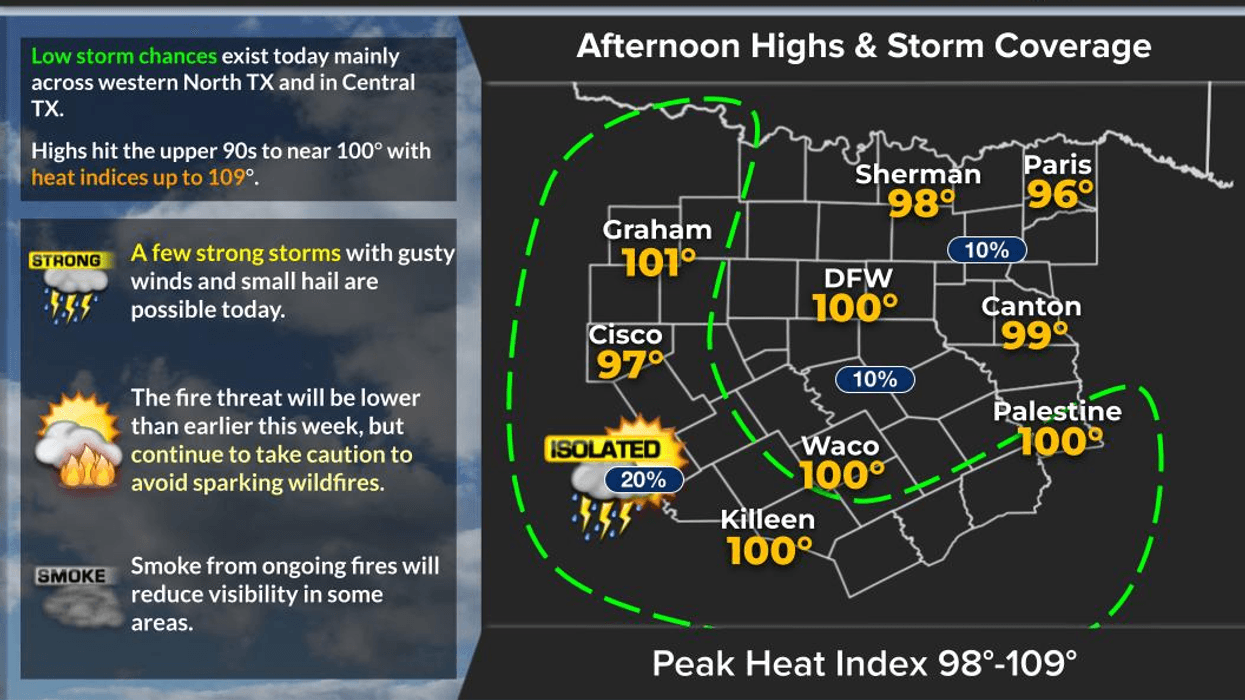
There will be some scattered showers and storms today, but they’ll stay well south of the Dallas-Fort Worth area. For us, it’s back to hot, dry conditions.
TODAY: Highs at or slightly above 100°, with feels-like temperatures approaching 105°. Heat Advisories are back in effect.
FRIDAY: More of the same. Highs around or slightly above 100°, with morning lows near 80°. Unfortunately, no rain is expected.
WEEKEND: Rinse and repeat! High pressure remains in control with afternoon highs around 101° and morning lows near 80°. South winds will begin picking up Sunday, with gusts around 20–25 mph.
That breezy pattern will stick around through at least the middle of next week, keeping the grass fire danger elevated.
MONDAY–WEDNESDAY: Temperatures will remain at or slightly above 100°, with morning lows around 80°. And yes… still no big changes in the forecast.
High pressure remains firmly in control through the end of next week, so please take the heat seriously.
If you’re working outdoors, stay hydrated and take frequent breaks. Please also check on the elderly and those who may need extra assistance during this prolonged heat.
I’m Meteorologist Dan Brunoff in the KRLD Weather Center. Have an awesome Thursday!
____________________________________________
7-Day Headlines:
- DFW Airport ONLY hit 101 degrees on Wednesday
- 32 triples this summer
- 41 days with no measurable rain at DFW
- HIGH GRASS FIRE DANGER!
- Heat Warnings gone/Heat Advisories replace
- Rain chance today west and south of DFW
- Near 100 degrees for the next week
- Download our AUDACY app! Listen to KRLD LIVE at home or at work
Almanac:
- Yest Rain: Trace; Yest High: 101; Low: 82
- Today’s Averages: High: 94; Low: 74
- Record high: 107 (1901); Record low 61 (1926)
- August rain: Trace; Deficit: <1.74”>
- 2026 Rain: 22.61”; Snow: 2.4”; Deficit: <1.50”>
- Sunrise: 7:00am; Sunset: 7:58pm
Forecast:
Thursday: **Heat Advisory** Mostly sunny. Isolated showers and storms, mainly south and west of DFW. High:101. Heat index: 105. Record high: 107 (1901). Wind: North 5-10 mph.
Thursday night: Partly cloudy and mild. Slight rain chances south and east of DFW. Low: Near 80. Wind: North 5-10.
Friday: **Possible Heat Advisory** Mostly sunny and hot. High: Near 100. Wind: East 5 mph.
Weekend: Mostly sunny, breezy and hot. Grass fire danger returns! Highs: 101.
Monday - Wednesday: Mostly sunny, breezy and hot. Grass fire danger! High: Near 100.
LISTEN on the Audacy App
Tell your Smart Speaker to "PLAY 1080 KRLD"
Sign Up to receive our KRLD Insider Newsletter for more news
Follow us on Facebook | Twitter | Instagram | YouTube