
UPDATE 3.11.22 @ 3:00 P.M.
The winter weather advisory has now been canceled for the metroplex.
UPDATE 3.11.22 @ 2:15 P.M.
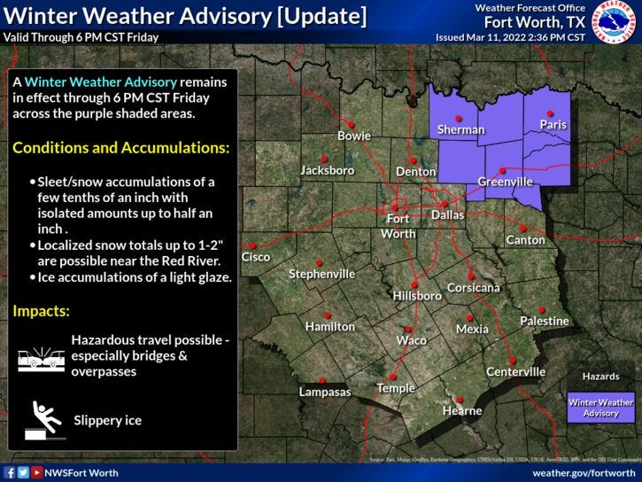
The bulk of the measurable precipitation is now slipping east of Dallas...mainly in the form of a cold rain. I'm not expecting any travel impacts across the Metroplex, even though a Winter Weather Advisory remains in effect until 6 PM. Parts of the advisory may be canceled before it's expiration time.
The main weather story through tomorrow morning will be the cold temperatures. Readings will hold steady today in the low to mid thirties. Windchills will be in the upper teens to low 20s.
There will be some slick spots to the northeast of Dallas on I-30 and north towards the Red River through this evening.
UPDATE 3.11.22 @ 11:00 A.M.
March wintry precipitation is the hardest to forecast for in North Texas. Looks like we dodged a bullet! I'm not concerned about icy bridges and overpasses except along the Red River through the remainder of Friday. We could see some sleet and some snow breaking out as the afternoon wears on, mainly east of a McKinney to Dallas line and North of I 20. There may also be some snow flurries this evening north of I 20 but no accumulation is expected.
A Winter Weather Advisory is in effect for parts of North Texas until 6 p.m. Friday. Precipitation started to break out west of Interstate 35W early Friday morning, will end from west to east Friday afternoon into the early evening.
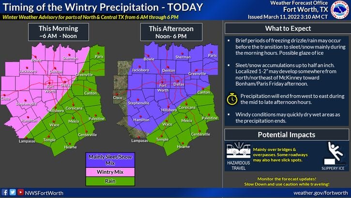
NOTE: It's very important to keep an eye on your car temperature thermometer on your dashboard or on your rearview mirror if you have to venture around today. Also, it's not out of the question that the metroplex may see a dusting or a 1/2 inch of snow later Friday, as the whole system swings through. Along the Red River Valley and up Interstate 30, northeast of Rockwall towards Texarkana and points north, people could see 1-2 inches.
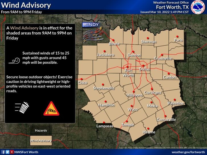
A Wind Advisory is also in effect today for gusts to 35 mph. This wind will be our friend later this afternoon through the evening because any moisture that hasn't frozen on the main roads will quickly evaporate. This will keep the ice potential down to less than 10% overnight and into Saturday morning. Areas that see a heavier burst of snow this afternoon, north and northeast of DFW, may have some slick spots on main roads through the overnight hours until about 9 a.m. Saturday.
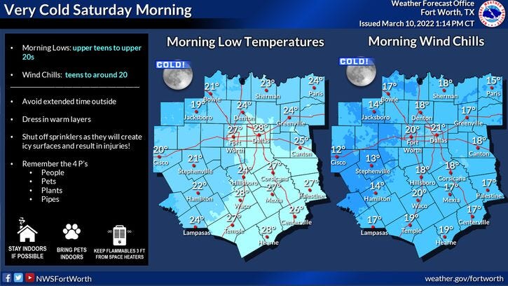
After temperatures hover near freezing Friday, we clear out and readings drop anywhere between 18 and 24 degrees across North Texas. The coldest temperatures will be where the heavier bursts fell snow today.
Layer up if you're heading to the Greenville Avenue Parade Saturday morning. Wind chills will be in the teens and you will start to shed layers as the morning and afternoon wear on. Afternoon highs will creep up into the low 50s with light wind and plenty of sunshine.
Our warming trend will continue Sunday through next week.
Keep checking back for updates via Facebook Lives and radar screenshots throughout the day.. Also listen to KRLD on our Audacy app for updates as well.
______________________________________________________
7-Day Headlines:
* High Thursday: 67 degrees at DFW.
* Winter Weather Advisory 6 a.m. to 6 p.m.
* A light wintry mix through Friday afternoon.
* Snow totals 0.5” (DFW) to 1.5” (NE).
* Bridges and overpasses main concern.
* Temperatures hover near freezing all day.
* Protect plants and pets Saturday morning.
* Cool Saturday, warming Sunday and Monday.
_________________________________________________________
*Thursday Rain: 0.00”; *Thursday High: 67; Low: 29
*Friday's Averages: High: 67; Low: 47
*Record high: 93 (1935); Record low: 11 (1948)
_________________________________________________________
*February rain: 0.20”; March deficit:
*2022 Rain: 2.31”; 2022 deficit
*Sunrise: 6:43am; Sunset: 6:33pm
**Winter Weather Advisory 6 a.m. - 6 p.m. Friday**
Friday: Cloudy, windy and cold. Light wintry mix starts later this morning, ends from west to east later this afternoon. Snow totals 0.5” (DFW) to 1.5” (NE). Bridges and overpasses the main concern. High: Steady 29-33. Wind: North 15-25, G35 mph.
Friday night: Decreasing clouds, windy and cold. Slick spots possible. Low: 18-25. Wind: NNE 10-15 mph.
Saturday: Sunny, less wind and cool. High: Low 50s. Wind: Light and Variable.
Sunday: Sunny, breezy, and warmer. High: Mid 60s.
Monday: Partly cloudy, breezy and warm. Scattered showers and storms EAST of DFW.High: Mid 70s.
Tuesday: Mostly sunny, breezy and a tad cooler. High: Mid 60s.
Wednesday: Sunny, windy and warm. High: Mid to upper 70s.
Thursday: Partly cloudy, windy and warm. Scattered showers and storms. High: Low 80s.
Related

LISTEN on the Audacy App
Sign Up and Follow NewsRadio 1080 KRLD