


PHILADELPHIA (KYW Newsradio) — It's July in Philadelphia and there were 14 tornado warnings issued Thursday night. Why?
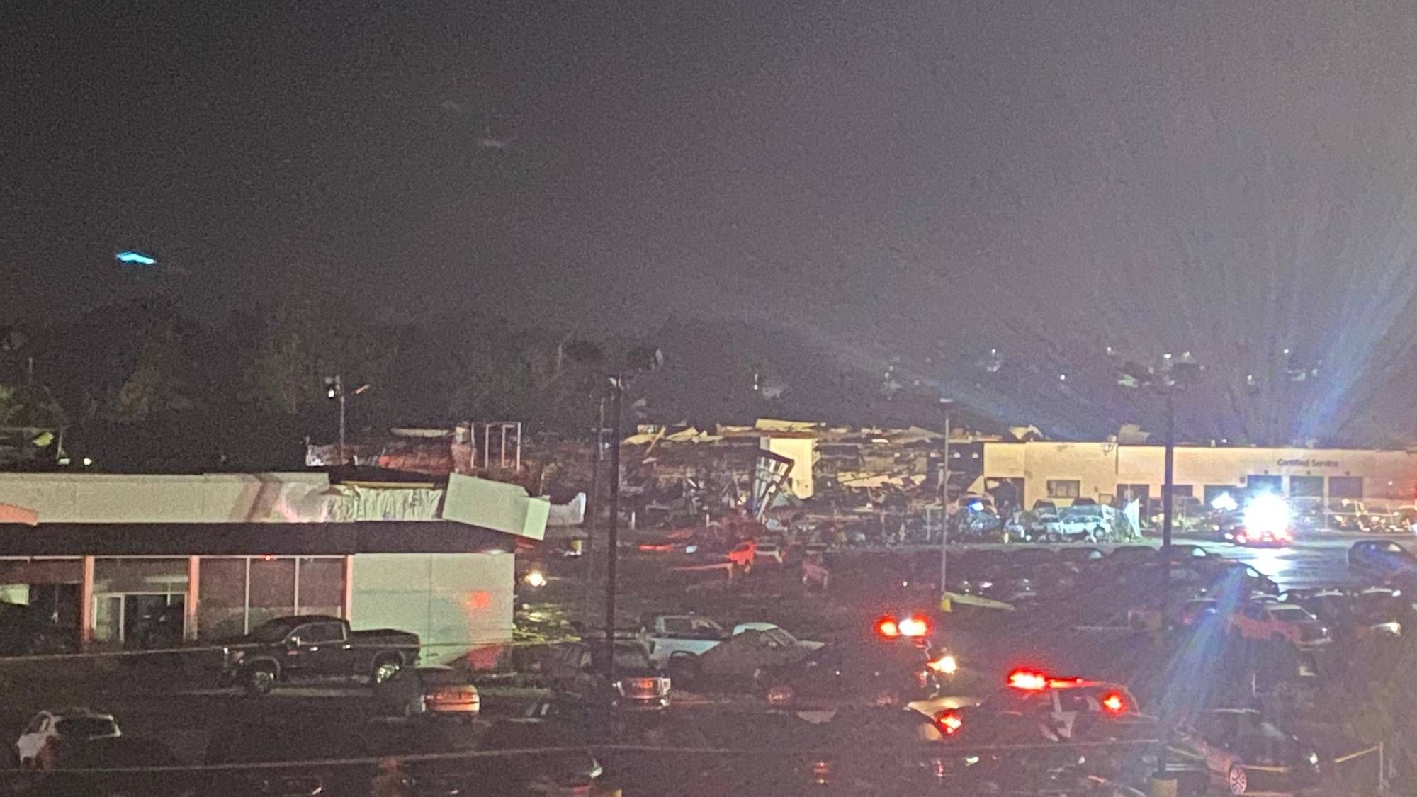
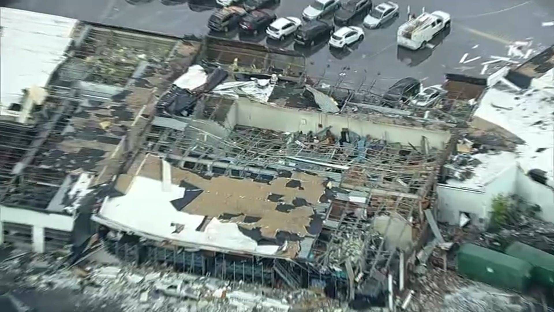
For anyone from the region, the onslaught of warnings — and the actual tornado that touched down in Bucks County — feel unprecedented.
To put it in perspective, NBC10 meteorologist Steve Sosna said three to four tornado warnings during a busy storm in the summertime would be incredibly active. Thursday had 14 warnings in a matter of four to five hours, and each one warned of extremely dangerous conditions. Last night's barrage of warnings nearly doubled the annual total, which stands at 29 for 2021, so far.
Where I was when it hit. #bensalem #tornado pic.twitter.com/r8pYv3nEJG
— money_heff (@HeffMoney) July 30, 2021
In fact, the Mount Holly office of the National Weather Service issued its first-ever particularly dangerous situation (PDS) tornado warning.
These warnings are more common in states like Texas or Alabama, but it is quite rare to see in the Philadelphia area. So, what is causing the severe weather blitz?
For one, we have better technology than we ever had before, Sosna said. Dual-polarization doppler radar optimizes tornado tracking, allowing meteorologists to see different types of phenomena going on.
"So yesterday," he said, "we were detecting debris, so we may be actually detecting tornadoes that we may have not been able to detect 10 or 15 years ago, thanks to radar technology."
There was also an extremely strong jetstream on Thursday with a lot of wind shear that was abnormal for this area.
"If you look back in history at some of the strongest tornadoes in our area, they have been in July, but we've never seen so many of them," Sosna added. "There are multiple storm surveys that are going to be happening today as a result of those ... warnings we had yesterday."
How to prepare for a tornado in the Philly region
It's not every day that there's a tornado warning in the Delaware Valley, so it may be hard to remember proper safety measures when the time comes. People collect fascinating footage of the damage in real-time, but Sosna said that is really the last thing people should do.
"When you hear 'warning,' that means the storm is imminent, there is a tornado likely imminent," he explained. "Now, not all these tornado warning storms produce tornadoes, but there's a likelihood of at the very least damaging winds. But the warning means that our radar technology is seeing a fast rotation in winds and that that thunderstorm is capable of dropping a tornado at any minute."
Sosna said you have to act immediately — drivers should pull off to the side of the road, or if you're already inside, take cover in an interior room without windows. Windows and glass can smash out and become flying debris.
"That's why getting into an interior room, putting as many walls between you and the outside as possible to keep yourself safe, and protecting your head, wearing a bicycle helmet. Taking a mattress — it sounds crazy, but this is proven science that it saves lives."
A basement is preferable, but for people in mobile homes — like in Thursday's event — it's advised that residents take action during a tornado watch, when conditions are favorable for a tornado. Sosna said they should leave and go to a safer, sturdier structure.
"That way, when the warning is issued, you're not scrambling at the last second," Sosna said. "Sometimes you only have 30 seconds, a minute, two minutes ahead of time to really take cover. And if you're in a mobile home, that's not enough time."
He suggested families create a preparedness plan now in the event of a tornado.
"Knowledge is power," he said. "Traditionally, Philadelphia is not an area you think about tornado drills in schools or with your family, but just like fire drills or any other kind of disaster type of preparedness, tornado safety should be factored in."
Is climate change causing more tornadoes?
Yes… sort of.
Part of the reason our region is seeing more tornadoes is due to the warmer temperatures, which cause more thunderstorms, Sosna explained. But Thursday's weather event cannot be directly tied to climate change. Exceptional events do happen across the country.
"Yesterday's event was rare, but there are pieces in climate change that are helping enhance these thunderstorms and making them stronger," he said. "When we give the forecast these days, rarely do we just say thunderstorms that are not severe. I can't even remember an instance this season where I was just talking about generic thunderstorms.
"It seems like every time we get thunderstorms around here now, due to the more heat, the urban heat island effect, due to parts of climate change, that these thunderstorms are almost like they're on steroids. They're just stronger these days."
Up until Thursday's storm, there were only two confirmed tornadoes in Delaware and three in New Jersey — all of which took place this month. It's been an incredibly active severe weather month, but Sosna said severe weather can really happen any time of year. Montgomeryville had one last November, for instance.
"We are living in a different climate now," he added. "Tornadoes do happen here and you got to take those warnings seriously. Act on it and also share all this information with friends. … It's just a personal conversation — bringing it up at dinner, bringing it up at a family gathering, of, 'Hey, I had a tornado warning. I acted on it and, my God, it saved my life.'"
CORRECTION: A previous version of this article stated that there were 29 tornado warnings issued on Thursday night. There were 14 Thursday night, and 29 for 2021 so far.


