


AUSTIN (Talk1370.com) -- Central Texas is continuing to see very light waves of freezing drizzle, rain, and even some sleet and snow flurries, ahead of our next winter storm system that is expected to bring significant snowfall and even colder temperatures to the Austin area - just the latest piece of what is shaping up to be a historic winter storm for Central Texas.
A WINTER STORM WARNING remains in effect for the entire Austin metro area until Noon on Monday...
A WIND CHILL WARNING will be in effect for the entire Austin metro area from 6PM Sunday until Noon Monday... wind chills down to negative 15 degrees.
Heavy sleet will pick up by the evening hours Sunday, turning into snow before midnight and continuing through Monday morning, likely coming to an end just before sunrise. Temperatures at Camp Mabry have now been below freezing since late Thursday afternoon, which means that any falling precipitation will now form into ice on any surface or roadway - not just exposed bridges and overpasses.
At this point, temperatures are unlikely to rise above the freezing mark for several days, which will potentially break a record for the longest period of sub-freezing temperatures in the capital city. Assuming the forecast holds and temperatures remain below 20 degrees on Monday, it will also mark the coldest day ever in Austin history.
Travel remains treacherous across the area, with first responders continuing to respond to minor crashes across Central Texas. Officials continue to discourage any travel unless it's absolutely necessary, with first responders even having trouble traversing the area's roadways due to icy conditions.
In addition to the roadways, area electric providers are facing challenges as ice on power lines and tree branches continue to wreak havoc on the electric grid. Austin Energy was able to make great progress Saturday on restoring power to nearly all of its customers; roughly 49,000 customers had lost power at some point since Thursday.
With temperatures falling into the single digits, wind chill values will also reach dangerous lows. A Wind Chill Warning will be in effect for the entire Austin metro from 6 p.m. Sunday night until noon on Monday, with wind chill values Sunday night into Monday morning expected to fall as low as 15 degrees below zero.
The snowstorm could likely be Austin's largest since the mid 1960s, when 4 inches of snow fell. In addition to the snow, winds are expected to gust between 30 to near 40mph - which may create near-blizzard conditions.
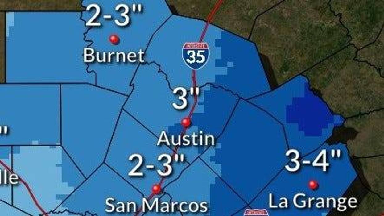
The National Weather Service is expecting anywhere from 2-4 inches in the Austin metro, with widespread higher totals north and west and isolated higher totals up to 6 inches or higher possible.
After snow showers come to an end Monday morning, clouds will clear, sending temperatures plummeting into the single digits - the coldest temperatures the area has seen since December 1989, and potentially even colder.
Low temperatures for both Sunday night into Monday morning and Monday night into Tuesday morning are expected to fall into the single digits in the Austin area. The latest forecast calls for lows in Austin to reach 9 degrees Monday morning, and 5 degrees Tuesday morning - the coldest temperatures the area has seen since Dec. 23, 1989. Wind chills are expected to be below zero, especially in the Hill Country where surface temperatures will be barely above the zero degree mark.
Once the extreme cold passes on Tuesday, a fourth round of winter precipitation is appearing likely on Wednesday, where the area could see another chance for a wintry mix and snow combination. Temperatures are expected to rebound some, but it remains to be seen if the area will climb above freezing before the end of the week.
With temperatures expected to remain below freezing for an extended period of time, local plumbers are recommending that if you haven't yet prepared your home for the onslaught of bitterly cold temperatures, it's recommended that you take those steps as quickly as you can.
Brad Casebier with Radiant Plumbing, on Friday's Cardle & Woolley show, called this winter blast "the real deal," saying that residents need to get prepared for the bitter cold. "When it doesn't get out of freezing for 24 hours, and it drops into the 20s, we typically get a surge of calls about broken pipes," Casebier said.
Casebier recommends that you drip your faucets inside your home, especially those that may be on exterior walls. For outside hose bibbs, Casebier recommends removing any attached hoses and then leaving the bibb dripping, in addition to covering or wrapping them. Pools and sprinkler systems will typically have a backflow preventer device that needs to be drained as well - another potentially expensive repair, Casebier said.


