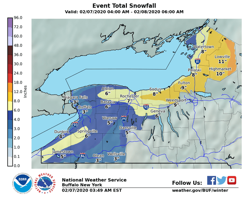

Buffalo, N.Y. (WBEN) - Wintry? Yes. But the snow and cold that is overspreading the Western New York region should be nothing more than a nuisance as snow totals are expected to be in the 3 to 5 inch range across the Buffalo metro area through early Saturday.
While the snow will accumulate during the day Friday, an overnight coating of freezing rain proved more problematic for drivers as windshields were glazed and untreated driveways, parking lots and roadways were slick.
National Weather Service meteorologist Kirk Apfel tells WBEN, "we're going to escape the real big amounts, the real heavy snow will be well to the east of the area, east of Rochester." "We're looking around 2 to 4 inches of snow across the Buffalo area", adds Apfel.
WINTER WEATHER ADVISORY REMAINS IN EFFECT UNTIL 6 AM ESTSATURDAY* WHAT...Snow and blowing snow. Snow accumulations of 4 to 8inches.* WHERE...Chautauqua, Cattaraugus, and Southern Erie counties.* WHEN...Until 6 AM EST Saturday.* IMPACTS...Travel could be very difficult. The hazardousconditions could impact the morning or evening commute.PRECAUTIONARY/PREPAREDNESS ACTIONS...Periods of snow, sleet or freezing rain will result in slipperyroads and limited visibilities. Slow down and use caution whiledriving.
WINTER WEATHER ADVISORY REMAINS IN EFFECT UNTIL 6 PM EST THISEVENING* WHAT...Mixed precipitation through daybreak, then heavy snowand blowing snow. Snow accumulations of 3 to 6 inches andadditional ice accumulations of around one tenth of an inch.* WHERE...Genesee, Wyoming, Livingston, and Allegany counties.* WHEN...Until 6 PM EST this evening.* IMPACTS...Plan on slippery road conditions. Areas of blowingsnow could significantly reduce visibility. The hazardousconditions could impact the morning or evening commute.PRECAUTIONARY/PREPAREDNESS ACTIONS...Periods of snow, sleet or freezing rain will result in slipperyroads and limited visibilities. Slow down and use caution whiledriving.
WINTER STORM WARNING REMAINS IN EFFECT UNTIL 6 AM ESTSATURDAY* WHAT...Mixed precipitation through daybreak, then heavy snowand blowing snow. Snow accumulations of 6 to 10 inches andadditional ice accumulations of around one tenth of an inch.Winds gusting as high as 35 mph.* WHERE...Orleans, Monroe, Wayne, and Northern Cayuga counties.* WHEN...Until 6 AM EST Saturday.* IMPACTS...Travel could be very difficult. Areas of blowingsnow could significantly reduce visibility. The hazardousconditions could impact the morning or evening commute.PRECAUTIONARY/PREPAREDNESS ACTIONS...Widespread accumulating snow and ice will create dangerous travelconditions.