Buffalo, N.Y. (WBEN) - At first, it was a bit tough for forecasters to gauge what was to come with a winter storm set to hit Western New York starting Wednesday. As the hours ticked away, closer to the storm's impact on the region, the outlook started to become more clear for many meteorologists.
"This is not going to be blizzard level. This is a different animal," said meteorologist Andy Parker during an appearance with Tom Bauerle on WBEN. "Ice and snow, you handle them completely differently, and what we have coming has the potential to be very impactful. It'd be one of the larger icing events that we've had in recent memory."
According to the National Weather Service, parts of Western New York could see anywhere between a tenth-of-an-inch up to a quarter-of-an-inch of ice accumulate on roadways, sidewalks, tree branches and power lines. Parker says the potential for a quarter-inch of ice is no joke.
"An ice storm does not come in with the ferocity of a blizzard. You don't have the wall of wind and the blinding snow. What you have is a trickle, and then the trickle goes to a steadier precipitation," he said of what's to come. "The light snow becomes a little steadier, then it changes and you start to get that chunky hunks a slush - either a chunky rain or a slushy snow drops from the sky. They're huge chunks of slush, and that's the atmosphere changing from the snow to the rain. It's blending, and then you start to get into a sleet. That's where you hear the pinging on your car. ... Then it switches to the stuff where it gets silent, and you think, 'Oh, it's just raining.' But it's really the freezing rain in there, and then you will switch to the rain.
"You've got all of those things, and all of those things happen within 50 miles. From Springville to the shoreline of Lake Ontario. That's the area that we're dealing with. From Buffalo all the way to Syracuse. It's that strip along the Thruway that's gonna be under the gun."
When it comes to the timing of the switch from snow to an icy mix, Parker estimates the Southern Tier will be the first see that transition on Wednesday, followed by the rest of the region - Southtowns up to the Lake Ontario shoreline - from maybe 5-8 p.m. EST. However, the key is that not everyone will see the transition happening at the same time.
"It's actually going to be a line that progresses up," Parker said. "If you're in West Seneca and you're starting to hear those pings, folks in the Northtowns might still say, 'Well I still see snow here.' It's literally going to change on a mile-by-mile basis. Eventually deeper into the evening, we're going to see some freezing rain, and it should swallow up all of Niagara County, Orleans, Northern Erie, Genesee, and a chunk of Central Erie County within that swath."
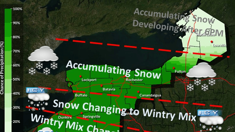
When it comes to the ice problems for the region, a tenth of an inch may seem like a tiny amount that's manageable. However, when it gets up to a quarter-inch, that's when Parker says things get worrisome.
"You start to see the wires hang a little. If you walk outside, you hear that eerie creaking of anything that's encased in ice, and there's going to be a breeze as well," he explained. "When we get to that amount, that's where things really become a little more problematic with the higher potential for power outages. You're gonna find more issues on roads freezing, even if they were partially treated."
Parker adds there's a couple of chances if the worst-case scenario happens, there could be more than a quarter-inch of ice in certain spots - primarily from around Buffalo up to the Lake Ontario shoreline, all the way East to Syracuse. The good news, though, is Parker says that is a very low potential situation.
"It's a significant enough icing event that if we just buried our heads and didn't speak of it, people are gonna get caught off guard. So we're giving you the heads up," Parker said. "If you can change some plans within that time period, maybe Thursday morning you can put something off, that's what you want to do."
While the weather forecast has become a little more clear just hours before arrival in Western New York, utility companies like National Grid have been preparing for the worst conditions to strike for several days now.
"There's always uncertainty, and you always want to be prepared," said National Grid spokesperson Dave Bertola on Tuesday. "With the winter storm system coming into town, we've extended our work shifts in anticipation or preparation for the snow and ice, and maybe these high winds that are supposed to batter Western New York on Wednesday and Thursday. In fact, we're doing the same thing with crews in Central and Eastern New York, so we're preparing all across the state with dozens of extra field crews and tree crews in the event that the icing of power lines and trees causes issues. That's really the concern."
While the possibility of ice always adds concern with tree limbs and branches falling on power lines, Bertola says there's also the concern of the weight it adds to the power lines themselves, which can sway in the breeze and high gusting winds, causing them to fall on the ground.
When trying to prepare for a storm that, for a long while, didn't affirm any details of snowfall or ice accumulation, Bertola says National Grid relies on past history to know it only takes a little bit of ice to cause power lines to come down.
"With ice and wind in the forecast, we're not one to take chances. So we want to be prepared to make sure our customers can continue to turn their lights on," he said. "We're prepared, and we just want to make sure that we have enough resources to spring into action if needed. We have barns - we call them barns - all across our service area. Olean, Fredonia, Angola, North Tonawanda, Buffalo, Batavia. We're going to have folks ready. We're going to keep an eye on things, and we're going to be ready to go if needed."
As part of National Grid's preparation, the company has activated its comprehensive emergency response plan, including:
- Securing external resources and mobilizing line, tree, service, damage assessment, and public safety workers.
- Pre-staging crews and materials in areas anticipated to be most severely impacted.
- Proactively reaching out to elected, municipal and emergency management officials to keep them updated on our preparations and provide safety information.
- Reaching out directly to customers through traditional and social media, email and texts and on our website to provide safety information and to urge them to be prepared.
- Conducting outbound calls to life support and critical facility customers to ensure they are prepared.
"The important thing is that we have people ready to go. We want to be as proactive as possible," Bertola said. "That's what our emergency response plan calls for, just to make sure that we have the right kinds of skilled folks out there ready to go and be able to respond in case of such emergency.
"We're not anticipating anything to the level of what we experienced Christmas weekend, but we're prepared and ready to go."