
A little bit of everything in the weekend forecast for Western New York, with wicked winds diminishing through the day Saturday, and then temperatures moderating into the 50's Sunday.
Strong winds that began to impact the region late Friday finally subsided through midday Saturday, but will return to the forecast as the weekend winds down and new work week begins.
"These winds are going to slowly diminish through the day," National Weather Service meteorologist Heather Kenyon tells WBEN. "By the afternoon we'll have wind gusts around the 20 to 25 mph(range)."
Conditions for the Old First Ward Parade Saturday won't be ideal, with temperatures in the upper 20's to near 30 degrees and very breezy conditions.
For the downtown St. Patrick's Day Parade Sunday, conditions will be more favorable.
"As we go into Sunday morning, we'll see a brief period of snow in the early morning hours," Kenyon cautions.
But there is a silver lining as the parade steps off at 2 p.m.
"We'll have temperatures reaching the 50's Sunday."
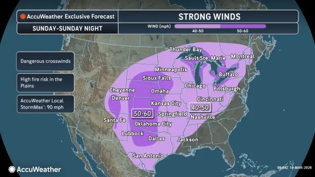
Looking ahead to the coming work week, strong winds will again impact much of the region Sunday night into Monday. Breezy conditions are expected across the region, with strong wind gusts of 35 to 45 mph, especially along the Chautauqua Ridge.
A Wind Advisory is posted for the Niagara Frontier and a High Wind Watch is posted for southern Erie County and the southern tier late Sunday through Monday.
Cold weather returns with gusty winds and lake effect snow Tuesday through Tuesday night.
Stay tuned!
WIND ADVISORY IN EFFECT FROM 5 PM SUNDAY TO 8 PM EDT MONDAY
* WHAT...South winds 25 to 35 mph with gusts up to 50 mph expected Sunday night. Winds become southwest Monday with a few gusts up to 50 mph.
* WHERE...Niagara, Orleans, Monroe, Oswego, Northern Erie, Genesee, Wyoming, Livingston, Cattaraugus, and Allegany Counties. Strongest gusts Sunday night through the northern slopes of the Bristol Hills, hills of Wyoming and Livingston Counties northward to around the New York State Thruway. Strongest wind gusts Monday will be regionwide.
* WHEN...From 5 PM Sunday to 8 PM EDT Monday. Strongest gusts expected Sunday night.
* IMPACTS...Gusty winds will blow around unsecured objects. Tree limbs could be blown down and a few power outages may result.
PRECAUTIONARY/PREPAREDNESS ACTIONS...
Use extra caution when driving, especially if operating a high profile vehicle. Secure outdoor objects.
HIGH WIND WATCH IN EFFECT FROM SUNDAY AFTERNOON THROUGH MONDAY EVENING
* WHAT...South to southeast winds 20 to 35 mph with gusts up to 60 mph possible through Sunday night. Winds become southwest Monday with a few gusts up to 50 mph.
* WHERE...Chautauqua and Southern Erie Counties. Strongest gusts Sunday night expected along the northwest downslope region of the Chautauqua Ridge and to the Lake Erie shoreline. Strongest wind gusts Monday will be regionwide.
* WHEN...From Sunday afternoon through Monday evening. Strongest gusts expected Sunday night.
* IMPACTS...Strong winds may blow down trees and power lines.
Scattered power outages are possible. Travel may be difficult, especially for high profile vehicles.
PRECAUTIONARY/PREPAREDNESS ACTIONS...
Monitor the latest forecasts and warnings for updates. Secure or shelter objects in a safe location prior to the onset of the strong winds.